File:Milano - mappa servizio ferroviario suburbano (schematica).svg
Jump to navigation
Jump to search

Size of this PNG preview of this SVG file: 612 × 599 pixels. Other resolutions: 245 × 240 pixels | 490 × 480 pixels | 784 × 768 pixels | 1,046 × 1,024 pixels | 2,091 × 2,048 pixels | 1,210 × 1,185 pixels.
Original file (SVG file, nominally 1,210 × 1,185 pixels, file size: 2.58 MB)
Captions
Captions
Add a one-line explanation of what this file represents
Summary[edit]
| Description |
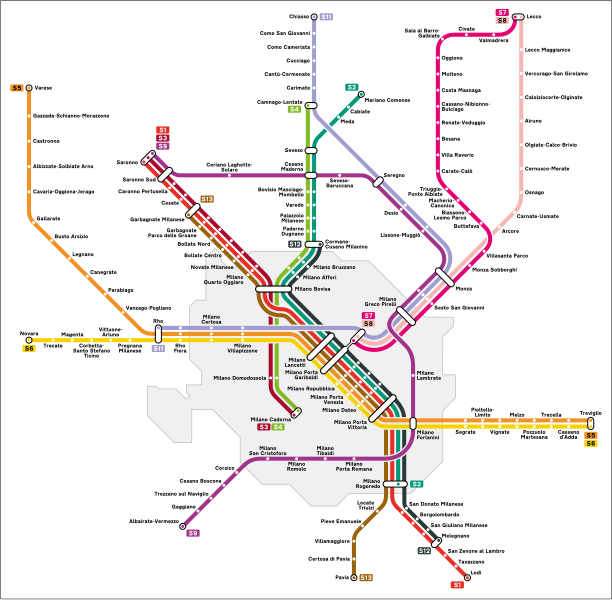
Italiano: Mappa del servizio ferroviario suburbano di Milano. |
| Source | Own work |
| Author | Arbalete |
| Permission (Reusing this file) |
I, the copyright holder of this work, hereby publish it under the following license: This file is licensed under the Creative Commons Attribution-Share Alike 4.0 International license.
|
| Other versions |
|
.png)
.svg&action=edit§ion=1)
File history
Click on a date/time to view the file as it appeared at that time.
.svg&dir=prev)
.svg&offset=20161015201135)
.svg&offset=&limit=20)
.svg&offset=&limit=50)
.svg&offset=&limit=100)
.svg&offset=&limit=250)
.svg&offset=&limit=500)
| Date/Time | Thumbnail | Dimensions | User | Comment | |
|---|---|---|---|---|---|
| current | 12:20, 2 October 2023 | | 1,210 × 1,185 (2.58 MB) | CiaobyDany (talk | contribs) | Aggiunta linea S12; correzioni minori |
| 00:30, 28 January 2023 |  | 1,210 × 1,185 (2.74 MB) | Arbalete (talk | contribs) | Non c'è alcuna linea in costruzione | |
| 12:11, 26 January 2023 |  | 1,210 × 1,185 (2.73 MB) | Arrow303 (talk | contribs) | Correzione linee S7/S8 + inserito prolungamento in costruzione S13 fino a Garbagnate M.se (cfr. Mappa Ufficiale Trenord novembre 2022: https://trenord-europe-trenord-endpoint-prd.azureedge.net/fileadmin/contenuti/TRENORD/2-Linee_e_orari/Linee_Suburbane_Urbane/Suburbano_2022_A4_linked_rev00_-_Copia.pdf) | |
| 20:58, 2 December 2022 |  | 1,210 × 1,185 (2.74 MB) | Arbalete (talk | contribs) | Piccola correzione | |
| 06:23, 2 December 2022 |  | 1,210 × 1,185 (2.74 MB) | Arbalete (talk | contribs) | Aggiorno con modifiche dell'11 dicembre 2022 (Milano Tibaldi, Villasanta Parco) | |
| 12:11, 16 June 2021 |  | 1,116 × 900 (1,004 KB) | Arbalete (talk | contribs) | Aggiorno (stazione Camerlata FS) | |
| 15:25, 13 January 2019 |  | 1,116 × 900 (999 KB) | Arbalete (talk | contribs) | Aggiorno (stazioni di Cesano Maderno Groane e Ceriano Groane chiuse il 10 dicembre 2012). | |
| 20:17, 15 October 2016 |  | 1,116 × 900 (1,012 KB) | I.sorry (talk | contribs) | Correzione colore ufficiale S12 | |
| 20:14, 15 October 2016 |  | 1,116 × 900 (1,012 KB) | I.sorry (talk | contribs) | Correzione colore ufficiale linea S12 | |
| 20:11, 15 October 2016 |  | 1,116 × 900 (1,012 KB) | I.sorry (talk | contribs) | Correzione colore ufficiale linea S12 |
You cannot overwrite this file.
File usage on Commons
The following 40 pages use this file:
- User:Arbalete/Maps
- User:Chumwa/OgreBot/Potential transport maps/2016 May 21-31
- User:Chumwa/OgreBot/Potential transport maps/2016 October 11-20
- User:Chumwa/OgreBot/Potential transport maps/2016 September 11-20
- User:Chumwa/OgreBot/Potential transport maps/2019 January 11-20
- User:Chumwa/OgreBot/Public transport information/2015 December 1-10
- User:Chumwa/OgreBot/Public transport information/2015 December 11-20
- User:Chumwa/OgreBot/Public transport information/2015 November 21-30
- User:Chumwa/OgreBot/Public transport information/2016 May 21-31
- User:Chumwa/OgreBot/Public transport information/2016 October 11-20
- User:Chumwa/OgreBot/Public transport information/2016 September 11-20
- User:Chumwa/OgreBot/Public transport information/2019 January 11-20
- User:Chumwa/OgreBot/Public transport information/2021 June 11-20
- User:Chumwa/OgreBot/Public transport information/2022 December 1-10
- User:Chumwa/OgreBot/Public transport information/2023 January 21-31
- User:Chumwa/OgreBot/Public transport information/2023 October 1-10
- User:Chumwa/OgreBot/Transport Maps/2015 December 1-10
- User:Chumwa/OgreBot/Transport Maps/2015 December 11-20
- User:Chumwa/OgreBot/Transport Maps/2015 November 21-30
- User:Chumwa/OgreBot/Transport Maps/2016 May 21-31
- User:Chumwa/OgreBot/Transport Maps/2016 October 11-20
- User:Chumwa/OgreBot/Transport Maps/2016 September 11-20
- User:Chumwa/OgreBot/Transport Maps/2019 January 11-20
- User:Chumwa/OgreBot/Transport Maps/2021 June 11-20
- User:Chumwa/OgreBot/Transport Maps/2022 December 1-10
- User:Chumwa/OgreBot/Transport Maps/2023 January 21-31
- User:Chumwa/OgreBot/Transport Maps/2023 October 1-10
- User:Chumwa/OgreBot/Travel and communication maps/2016 May 21-31
- User:Chumwa/OgreBot/Travel and communication maps/2016 October 11-20
- User:Chumwa/OgreBot/Travel and communication maps/2016 September 11-20
- User:Chumwa/OgreBot/Travel and communication maps/2019 January 11-20
- User:J budissin/Uploads/BiH/2019 January 11-20
- User:Magog the Ogre/Multilingual legend/2021 June 11-20
- User:Magog the Ogre/Multilingual legend/2022 December 1-10
- User:Magog the Ogre/Multilingual legend/2023 January 21-31
- User:Magog the Ogre/Multilingual legend/2023 October 1-4
- File:Milano - mappa servizio ferroviario suburbano (schematica).png
- File:Milano linee S.svg (file redirect)
- File:Milano mappa servizio ferroviario suburbano.svg (file redirect)
- Category:Milan suburban railway service
File usage on other wikis
The following other wikis use this file:
- Usage on de.wikipedia.org
- Usage on en.wikipedia.org
- Usage on fr.wikipedia.org
- Usage on it.wikipedia.org
- Usage on ja.wikipedia.org
- Usage on ko.wikipedia.org
- Usage on lmo.wikipedia.org
- Usage on oc.wikipedia.org
- Usage on pnb.wikipedia.org
- Usage on ur.wikipedia.org
- Usage on www.wikidata.org
- Usage on zh.wikipedia.org
.svg&oldid=807491804)