File:Mirkwood between the Carpathians and Dnieper.svg
Jump to navigation
Jump to search

Size of this PNG preview of this SVG file: 800 × 577 pixels. Other resolutions: 320 × 231 pixels | 640 × 462 pixels | 1,024 × 739 pixels | 1,280 × 923 pixels | 2,560 × 1,846 pixels | 1,840 × 1,327 pixels.
Original file (SVG file, nominally 1,840 × 1,327 pixels, file size: 1.58 MB)
Captions
Captions
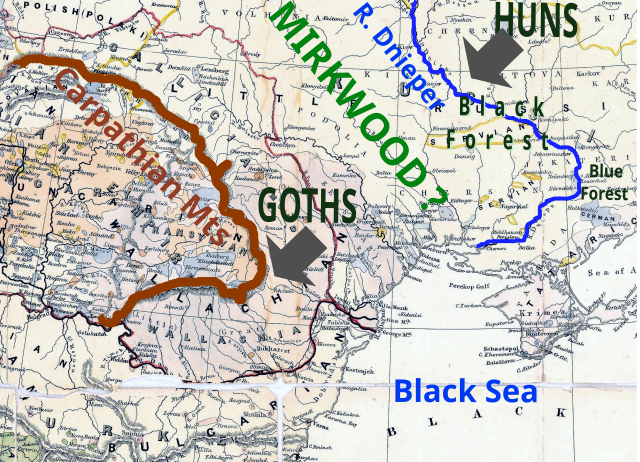
Map showing the possible location of the original Mirkwood between the Carpathian Mountains and the River Dnieper
Summary[edit]
| Description |
English: Map showing the possible location of the original Mirkwood between the Carpathian Mountains and the River Dnieper (Myrkviðr), as discussed by Tom Shippey. The Atlakviða and the Hlöðskviða both mention that Mirkwood is next to the River Dnieper; the Hervarar saga names the Carpathians. If this is correct then Mirkwood forms the border between the Goths and the Huns of the 4th century.
Shippey, Tom. "Goths and Huns: the rediscovery of the Northern cultures in the nineteenth century". in The Medieval Legacy: A Symposium. ed. Andreas Haarder et al. Odense University Press, 1982. pages 51-69 |
||||||||||||||||||||||||||||||||||||||||
| Date | |||||||||||||||||||||||||||||||||||||||||
| Source |
Own work Base map: File:Carpathians to Dnieper.jpg |
||||||||||||||||||||||||||||||||||||||||
| Author |
Graphics: Ian Alexander Base map:
|
||||||||||||||||||||||||||||||||||||||||


Licensing[edit]
I, the copyright holder of this work, hereby publish it under the following license:
This file is licensed under the Creative Commons Attribution-Share Alike 4.0 International license.
- You are free:
- to share – to copy, distribute and transmit the work
- to remix – to adapt the work
- Under the following conditions:
- attribution – You must give appropriate credit, provide a link to the license, and indicate if changes were made. You may do so in any reasonable manner, but not in any way that suggests the licensor endorses you or your use.
- share alike – If you remix, transform, or build upon the material, you must distribute your contributions under the same or compatible license as the original.
File history
Click on a date/time to view the file as it appeared at that time.
| Date/Time | Thumbnail | Dimensions | User | Comment | |
|---|---|---|---|---|---|
| current | 15:25, 8 January 2022 | | 1,840 × 1,327 (1.58 MB) | Chiswick Chap (talk | contribs) | label |
| 11:40, 13 August 2021 |  | 1,840 × 1,327 (1.58 MB) | Chiswick Chap (talk | contribs) | arrow style | |
| 16:52, 15 March 2021 |  | 1,840 × 1,327 (1.57 MB) | Chiswick Chap (talk | contribs) | show 'Black' and 'Blue' proposed locations | |
| 09:52, 9 March 2021 |  | 1,880 × 1,393 (1.56 MB) | Chiswick Chap (talk | contribs) | labels | |
| 16:23, 8 August 2020 |  | 1,880 × 1,393 (1.56 MB) | Chiswick Chap (talk | contribs) | colour balance of background map | |
| 10:38, 15 July 2020 |  | 1,880 × 1,393 (1.31 MB) | Chiswick Chap (talk | contribs) | labels | |
| 14:19, 8 July 2020 |  | 1,880 × 1,393 (1.31 MB) | Chiswick Chap (talk | contribs) | Uploaded own work with UploadWizard |
You cannot overwrite this file.
File usage on Commons
There are no pages that use this file.
File usage on other wikis
The following other wikis use this file:
- Usage on en.wikipedia.org
- Usage on uk.wikipedia.org