File:Misty Sunset over Wasatch Mountains, U.S. Route 6, Santaquin, Utah 2.jpg

Original file (4,000 × 3,000 pixels, file size: 3.12 MB, MIME type: image/jpeg)
Captions
Captions
Summary[edit]
| Description |
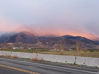
The Wasatch Range is a mountain range that stretches approximately 160 miles (260 km) from the Utah-Idaho border, south through central Utah in the western United States. It is the western edge of the greater Rocky Mountains, and the eastern edge of the Great Basin region. The northern extension of the Wasatch Range, the Bear River Mountains, extends just into Idaho, constituting all of the Wasatch Range in that state. According to the Utah History Encyclopedia, Wasatch in Ute means "mountain pass" or "low pass over high range." According to William Bright the mountains were named for a Shoshoni leader who was named with the Shoshoni term wasattsi, meaning "blue heron". Since the earliest days of settlement, the majority of Utah's population has chosen to settle along the range's western front, where numerous river drainages exit the mountains. The mountains were a vital source of water, timber, and granite for early settlers. Today, 85% of Utah's population lives within 15 miles (24 km) of the Wasatch Range, mainly in the valleys just to the west. This concentration is known as the Wasatch Front and has a population of just over 2,000,000 residents. Salt Lake City lies between the Wasatch Range and the Great Salt Lake. At 11,928 feet (3,636 m), Mount Nebo, a triple peak rising above Nephi, Utah at the southern end of the range, is the highest peak of the Wasatch. In some places the mountains rise immediately from the valley's base elevation of 4,330 feet (1,320 m) to over 11,000 feet (3,582 m), producing steep inclines. Other notable peaks include Mount Timpanogos, a massive peak which looms over much of southern Salt Lake County and northern Utah County and is especially prominent from Provo; Lone Peak, the Twin Peaks, and Mount Olympus, which overlook the Salt Lake Valley; Francis Peak overlooking both Morgan and Davis counties; and Ben Lomond and Mount Ogden, both near Ogden, Utah. Since they top out just below 12,000 feet (3,700 m), Wasatch peaks are not especially high compared to the Colorado Rockies or even the Uinta Mountains, the other main portion of the Rocky Mountains in Utah. However, they are sculpted by glaciers, yielding notably rugged, sweeping upland scenery comparing well with other prominent ranges of western North America. They also receive heavy falls of snow, in some places over 500 inches (1,300 cm) per year. This great snowfall, with its runoff, made possible a prosperous urban strip of some 25 cities along nearly 100 miles (160 km) of mountain frontage. The Wasatch Range is home to a high concentration of ski areas, with 11 stretching from Sundance in northern Utah County to Powder Mountain and Wolf Mountain northeast of Ogden. There is also one ski resort in the Bear River Mountains (Beaver Mountain). Park City alone is bordered by three ski resorts. Due to the low relative humidity in wintertime, along with the added lake-effect from the Great Salt Lake, the snow has a dry, powdery texture which most of the local ski resorts market as "the Greatest Snow on Earth". The high concentration of ski resorts located close to a major urban area, as well as the famed light, powdery snow that's often considered good for skiing, were prime reasons for Salt Lake City's hosting of the 2002 Winter Olympics. Several of the Wasatch canyons in the Lone Peak area, most notably Little Cottonwood Canyon, have a number of high-quality granite outcroppings, and make up a popular climbing area such as the Pfeifferhorn. Further north, Big Cottonwood Canyon features tricky climbing on quartzite. The densely vegetated narrow canyons of the Wasatch Range, such as Big Cottonwood Canyon and Little Cottonwood Canyon are heavily visited; on September 25, 2005, 1,200 automobiles entered Little Cottonwood within one hour. The canyons are located within 24 miles (39 km) of downtown Salt Lake City and the year-round paved roadways can reach 5,000 ft (1,500 m) higher in elevation above the city within a short distance. Dirt roads readily drivable in passenger cars with moderate clearance stretch up from Park City, Heber, and Big Cottonwood Canyon. These reach about 10,000 feet (3,000 m) above sea level and provide impressive long-range high country views. <a href="http://en.wikipedia.org/wiki/Wasatch_Range" rel="noreferrer nofollow">en.wikipedia.org/wiki/Wasatch_Range</a> <a href="http://en.wikipedia.org/wiki/Wikipedia:Text_of_Creative_Commons_Attribution-ShareAlike_3.0_Unported_License" rel="noreferrer nofollow">en.wikipedia.org/wiki/Wikipedia:Text_of_Creative_Commons_...</a> |
| Date | Taken on 1 November 2014, 17:20 |
| Source | Misty Sunset over Wasatch Mountains, U.S. Route 6, Santaquin, Utah |
| Author | Ken Lund from Reno, Nevada, USA |
| Camera location | | View this and other nearby images on: OpenStreetMap |
|---|
Licensing[edit]
- You are free:
- to share – to copy, distribute and transmit the work
- to remix – to adapt the work
- Under the following conditions:
- attribution – You must give appropriate credit, provide a link to the license, and indicate if changes were made. You may do so in any reasonable manner, but not in any way that suggests the licensor endorses you or your use.
- share alike – If you remix, transform, or build upon the material, you must distribute your contributions under the same or compatible license as the original.
| This image was originally posted to Flickr by Ken Lund at https://flickr.com/photos/75683070@N00/15672771796 (archive). It was reviewed on 24 June 2019 by FlickreviewR 2 and was confirmed to be licensed under the terms of the cc-by-sa-2.0. |
File history
Click on a date/time to view the file as it appeared at that time.
| Date/Time | Thumbnail | Dimensions | User | Comment | |
|---|---|---|---|---|---|
| current | 19:14, 24 June 2019 | | 4,000 × 3,000 (3.12 MB) | Noahedits (talk | contribs) | Transferred from Flickr via #flickr2commons |
You cannot overwrite this file.
File usage on Commons
There are no pages that use this file.
File usage on other wikis
The following other wikis use this file:
- Usage on en.wikipedia.org