File:Modern Map of the Southern United States.png
Jump to navigation
Jump to search
No higher resolution available.
Modern_Map_of_the_Southern_United_States.png (566 × 365 pixels, file size: 13 KB, MIME type: image/png)
Captions
Captions
Add a one-line explanation of what this file represents
Summary[edit]
| Description |
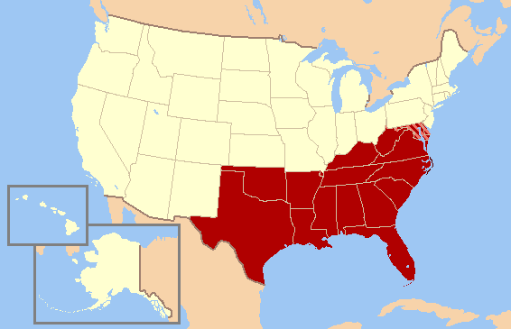
English: Map of the what the Southern United States as defined by the U.S. Census Bureau. The striped states (Maryland and Delaware) and Washington D.C. are now often considered part of the Northeast and/or Mid-Atlantic by many other sources, public and private, due to economic, demographic, cultural, and political alignments. |
| Date | |
| Source | File:US map-South Modern.png |
| Author | User:Astrokey44 |
Licensing[edit]
This file is licensed under the Creative Commons Attribution-Share Alike 3.0 Unported license.
- You are free:
- to share – to copy, distribute and transmit the work
- to remix – to adapt the work
- Under the following conditions:
- attribution – You must give appropriate credit, provide a link to the license, and indicate if changes were made. You may do so in any reasonable manner, but not in any way that suggests the licensor endorses you or your use.
- share alike – If you remix, transform, or build upon the material, you must distribute your contributions under the same or compatible license as the original.
File history
Click on a date/time to view the file as it appeared at that time.
| Date/Time | Thumbnail | Dimensions | User | Comment | |
|---|---|---|---|---|---|
| current | 01:56, 6 May 2013 | | 566 × 365 (13 KB) | 007bond (talk | contribs) | User created page with UploadWizard |
You cannot overwrite this file.
File usage on Commons
There are no pages that use this file.
File usage on other wikis
The following other wikis use this file:
- Usage on en.wikipedia.org
- Usage on ja.wikipedia.org
- Usage on sc.wikipedia.org
- Usage on tr.wikipedia.org