File:Morgan Jones Kiln, Virginia Historical Marker No. JT-14; Bushfield, Virginia Historical Marker No. JT-5; The Glebe, Virginia Historical Marker No. JT-3, Mount Holly, Virginia (14484889684).jpg
Original file (4,000 × 3,000 pixels, file size: 3.43 MB, MIME type: image/jpeg)
Captions
Captions
Summary[edit]
.jpg&action=edit§ion=1)
| Description |
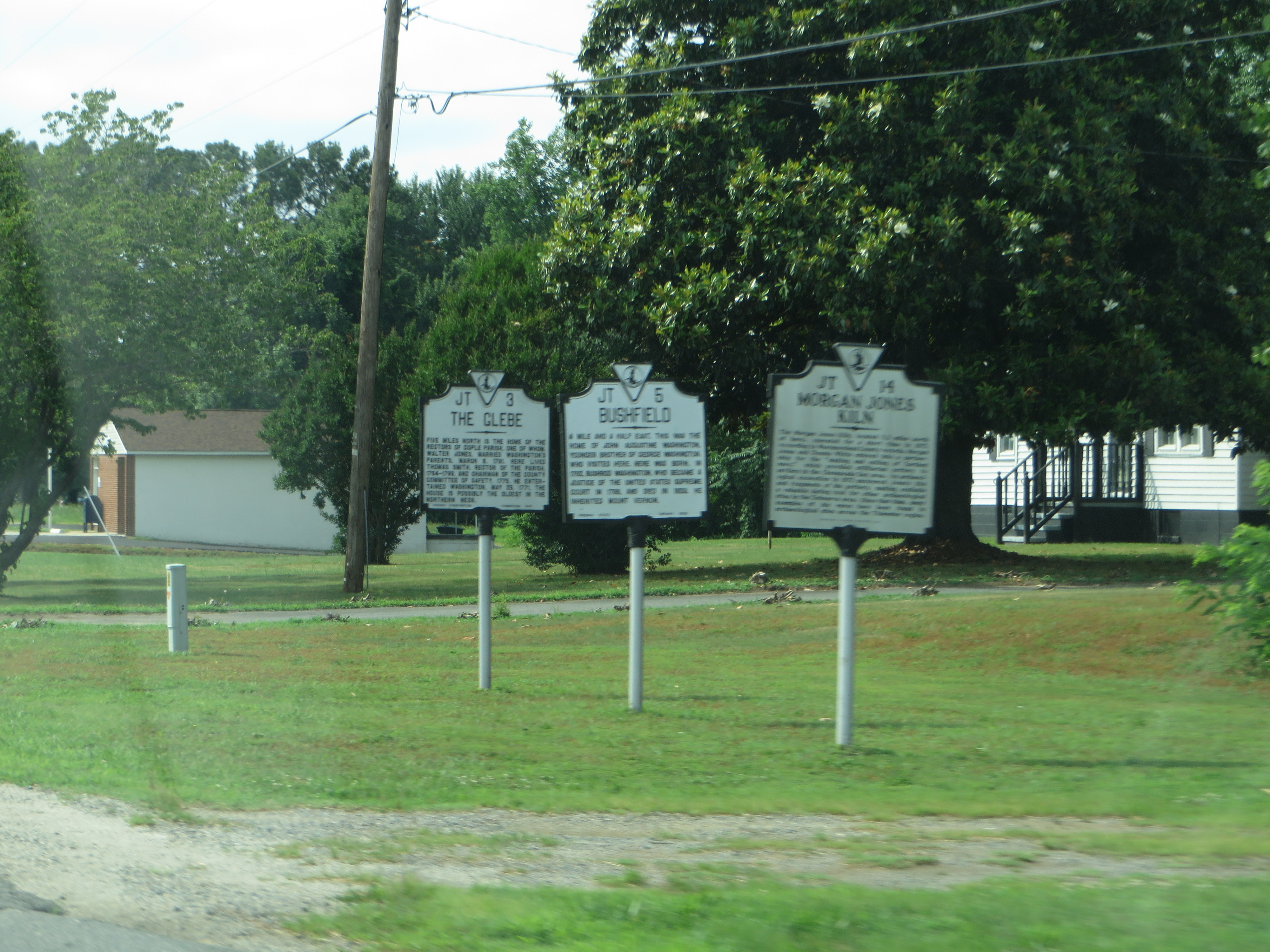
The Glebe: Five miles north is the home of the rectors of Cople Parish, one of whom, Walter Jones, married Washington's parents, March 6, 1731. Here lived Thomas Smith, rector of the parish, 1764-1799, and chairman of the county Committee of Safety, 1775. He entertained Washington, May 25, 1771. The house is possibly the oldest in the Northern Neck. Bushfield: A mile and a half east. This was the home of John Augustine Washington, younger brother of George Washington, who visited here. Here was born, in 1762, Bushrod Washington, who became a justice of the United States Supreme Court in 1798, and died in 1829. He inherited Mount Vernon. Morgan Jones Kiln: The Morgan Jones Kiln, located 5.2 miles north of here, operated for a short time in 1677. According to Westmoreland County records, Morgan Jones and Dennis White entered into a partnership for the "making and selling of Earthen ware," which provided utilitarian pottery to setlers in the Chesapeake Bay area. An archaological excavation in 1973 uncovered Jones's kiln and fragments of his pottery, making available a valuable dating tool for the archaological sites in the Delmarva area. Since that time, many examples of his wares have been found in archaological sites across the Tidewater region. |
| Date | |
| Source | Morgan Jones Kiln, Virginia Historical Marker No. JT-14; Bushfield, Virginia Historical Marker No. JT-5; The Glebe, Virginia Historical Marker No. JT-3, Mount Holly, Virginia |
| Author | Ken Lund from Reno, Nevada, USA |
| Camera location | | View this and other nearby images on: OpenStreetMap |
|---|
.jpg¶ms=038.091372_N_-076.718700_E_globe:Earth_type:camera_source:Flickr_&language=en)
Licensing[edit]
.jpg&action=edit§ion=2)
- You are free:
- to share – to copy, distribute and transmit the work
- to remix – to adapt the work
- Under the following conditions:
- attribution – You must give appropriate credit, provide a link to the license, and indicate if changes were made. You may do so in any reasonable manner, but not in any way that suggests the licensor endorses you or your use.
- share alike – If you remix, transform, or build upon the material, you must distribute your contributions under the same or compatible license as the original.
| This image was originally posted to Flickr by Ken Lund at https://flickr.com/photos/75683070@N00/14484889684. It was reviewed on 6 April 2016 by FlickreviewR and was confirmed to be licensed under the terms of the cc-by-sa-2.0. |
File history
Click on a date/time to view the file as it appeared at that time.
| Date/Time | Thumbnail | Dimensions | User | Comment | |
|---|---|---|---|---|---|
| current | 17:33, 6 April 2016 | | 4,000 × 3,000 (3.43 MB) | Ser Amantio di Nicolao (talk | contribs) | Transferred from Flickr via Flickr2Commons |
You cannot overwrite this file.
File usage on Commons
There are no pages that use this file.
.jpg&oldid=575748778)