File:Mount Kilimanjaro Geology map-es.svg
Jump to navigation
Jump to search

Size of this PNG preview of this SVG file: 800 × 516 pixels. Other resolutions: 320 × 206 pixels | 640 × 413 pixels | 1,024 × 660 pixels | 1,280 × 825 pixels | 2,560 × 1,650 pixels | 2,670 × 1,721 pixels.
Original file (SVG file, nominally 2,670 × 1,721 pixels, file size: 1.03 MB)
Captions
Captions
Add a one-line explanation of what this file represents
| Description |
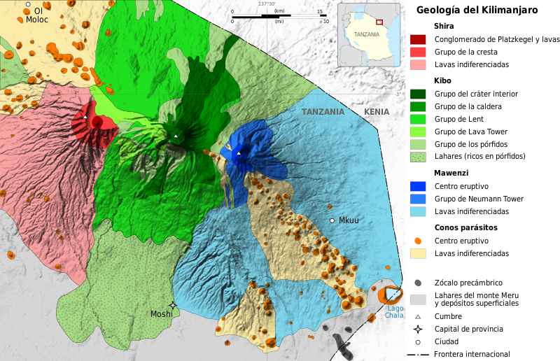
English: Simplified geological map of the three volcanic centres of Mount Kilimanjaro (modified after Downie et al., 1965), Tanzania. Français : Carte géologique simplifiée du Kilimandjaro, Tanzanie. Español: Mapa geológico del Kilimanjaro, Tanzania. |
| Date | (UTC) |
| Source | |
| Author |
|
| Other versions |
|


.svg)

.png)
| This is a retouched picture, which means that it has been digitally altered from its original version. Modifications: Textos en español. The original can be viewed here: Mount Kilimanjaro Geology map-fr.svg:
|
I, the copyright holder of this work, hereby publish it under the following licenses:
This file is licensed under the Creative Commons Attribution-Share Alike 3.0 Unported, 2.5 Generic, 2.0 Generic and 1.0 Generic license.
- You are free:
- to share – to copy, distribute and transmit the work
- to remix – to adapt the work
- Under the following conditions:
- attribution – You must give appropriate credit, provide a link to the license, and indicate if changes were made. You may do so in any reasonable manner, but not in any way that suggests the licensor endorses you or your use.
- share alike – If you remix, transform, or build upon the material, you must distribute your contributions under the same or compatible license as the original.

|
Permission is granted to copy, distribute and/or modify this document under the terms of the GNU Free Documentation License, Version 1.2 or any later version published by the Free Software Foundation; with no Invariant Sections, no Front-Cover Texts, and no Back-Cover Texts. A copy of the license is included in the section entitled GNU Free Documentation License. |
You may select the license of your choice.
Original upload log[edit]
This image is a derivative work of the following images:
- File:Mount_Kilimanjaro_Geology_map-fr.svg licensed with Cc-by-sa-3.0,2.5,2.0,1.0, GFDL
- 2009-04-30T20:37:00Z Sémhur 2670x1721 (1079525 Bytes) Misspelling
- 2009-04-30T19:49:24Z Sémhur 2670x1721 (1079355 Bytes) == Description == {{Information |Description= {{en|1=Simplified geological map of the three volcanic centres of [[:en:Mount Kilimanjaro|Mount Kilimanjaro]] (modified after Downie et al., 1965), Tanzania.}} {{fr|1=Carte géolo
Uploaded with derivativeFX
File history
Click on a date/time to view the file as it appeared at that time.
| Date/Time | Thumbnail | Dimensions | User | Comment | |
|---|---|---|---|---|---|
| current | 23:18, 22 May 2010 | | 2,670 × 1,721 (1.03 MB) | Furado (talk | contribs) | {{Information |Description={{en|1=Simplified geological map of the three volcanic centres of Mount Kilimanjaro (modified after Downie et al., 1965), Tanzania.}} {{fr|1=Carte géologique simplifiée du [[:fr:Kilimandjaro|Kilimandj |
You cannot overwrite this file.
File usage on Commons
The following 7 pages use this file:
- File:Mount Kilimanjaro Geology map-fr.jpg
- File:Mount Kilimanjaro Geology map-fr.svg
- File:Mount Kilimanjaro Geology map-gl.svg
- File:Mount Kilimanjaro Geology map-nl.png
- File:Mount Kilimanjaro Geology map-nl.svg
- File:Mount Kilimanjaro Geology map-nl (crop).png
- File:Mount Kilimanjaro Geology map-nl (crop).svg
File usage on other wikis
The following other wikis use this file:
- Usage on es.wikipedia.org