File:Mughals India 17th century-cs.png
(Redirected from File:Mughals India 18th centur-cs.png)

Size of this preview: 407 × 599 pixels. Other resolutions: 163 × 240 pixels | 326 × 480 pixels | 522 × 768 pixels | 1,116 × 1,642 pixels.
Original file (1,116 × 1,642 pixels, file size: 576 KB, MIME type: image/png)
Captions
Captions
Add a one-line explanation of what this file represents
| Description |
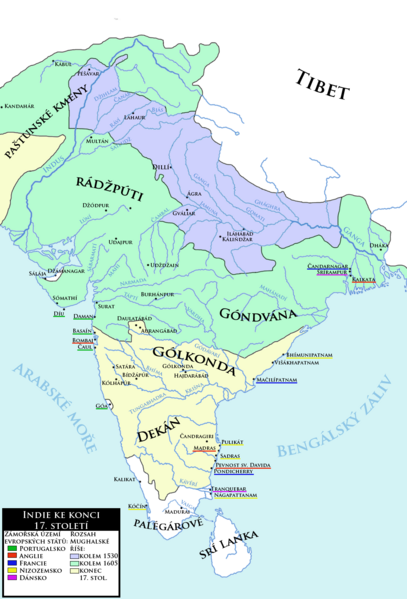
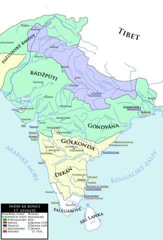
Čeština: Indie ke konci 17. století spolu se zobrazením expanze Mughalské říše a základním přhledem evropských kolonií v oblasti
English: India at the end of the 17th century with expansion of the Moghul Empire and basic overview of European colonies in the area. (Czech language) |
| Date | (UTC) |
| Source | |
| Author |
|
| Other versions | العربيَّة |
| This is a retouched picture, which means that it has been digitally altered from its original version. Modifications: new map, combination of charts made by Joppe and another one to correct the extent of Moghul power. The original can be viewed here: Mughal empire large.png:
|
| I, the copyright holder of this work, release this work into the public domain. This applies worldwide. In some countries this may not be legally possible; if so: I grant anyone the right to use this work for any purpose, without any conditions, unless such conditions are required by law. |
Original upload log[edit]
This image is a derivative work of the following images:
- File:India_in_1525_Joppen.jpg licensed with PD-US
- 2010-03-06T23:44:16Z Abecedare 1251x1824 (343051 Bytes) {{Information |Description={{en|1=Map of India in 1525}} |Source= "Historical Atlas of India," by Charles Joppen (London: Longmans, Green & Co., 1907) |Author=Charles Joppen |Date=1907 |Permission= |other_versions= }}
- File:India_in_1605.jpg licensed with PD-US
- 2010-03-06T23:47:37Z Abecedare 1248x1832 (333121 Bytes) == Summary == {{Information |Description={{en|1=Map of India in 1605}} |Source= "[http://www.columbia.edu/itc/mealac/pritchett/00maplinks/mughal/joppenset/joppenset.html Historical Atlas of India]," by Charles Joppen (London:
- File:India_in_1700_Joppen.jpg licensed with PD-US
- 2010-03-06T23:48:41Z Abecedare 1259x1820 (305244 Bytes) == Summary == {{Information |Description={{en|1=Map of India in 1700}} |Source= "[http://www.columbia.edu/itc/mealac/pritchett/00maplinks/mughal/joppenset/joppenset.html Historical Atlas of India]," by Charles Joppen (London:
- File:Mughal_empire_large.png licensed with Cc-pd-mark-footer, PD-USGov
- 2005-03-24T22:23:36Z Bontenbal 500x664 (94593 Bytes) {{PD-USGov}} [[category:Historical maps]][[category:Maps of India]] Source [[:en:Image:Mughal empire large.png]]
Uploaded with derivativeFX
File history
Click on a date/time to view the file as it appeared at that time.
| Date/Time | Thumbnail | Dimensions | User | Comment | |
|---|---|---|---|---|---|
| current | 09:33, 12 April 2013 | | 1,116 × 1,642 (576 KB) | Mozzan (talk | contribs) | Correction of factography |
| 11:35, 8 October 2011 |  | 1,100 × 1,560 (574 KB) | Podzemnik (talk | contribs) | little cropped on the top and right | |
| 21:06, 7 October 2011 |  | 1,116 × 1,642 (576 KB) | Mozzan (talk | contribs) | {{Information |Description={{cs|1=Indie ke konci 18. století spolu se zobrazením expanze Mughalské říše a základním přhledem evropských kolonií v oblasti}} {{en|1=India at the end of the 18th century with expansion of the Moghul Empire and basi |
You cannot overwrite this file.
File usage on Commons
The following page uses this file:
- File:Mughals India 18th centur-cs.png (file redirect)
File usage on other wikis
The following other wikis use this file:
- Usage on cs.wikipedia.org