File:Mysore Taluk (2011 Census) (cropped).jpg
Jump to navigation
Jump to search
Size of this preview: 800 × 542 pixels. Other resolutions: 320 × 217 pixels | 640 × 433 pixels | 818 × 554 pixels.
Original file (818 × 554 pixels, file size: 167 KB, MIME type: image/jpeg)
Captions
Captions
Add a one-line explanation of what this file represents
Summary[edit]
| Description |
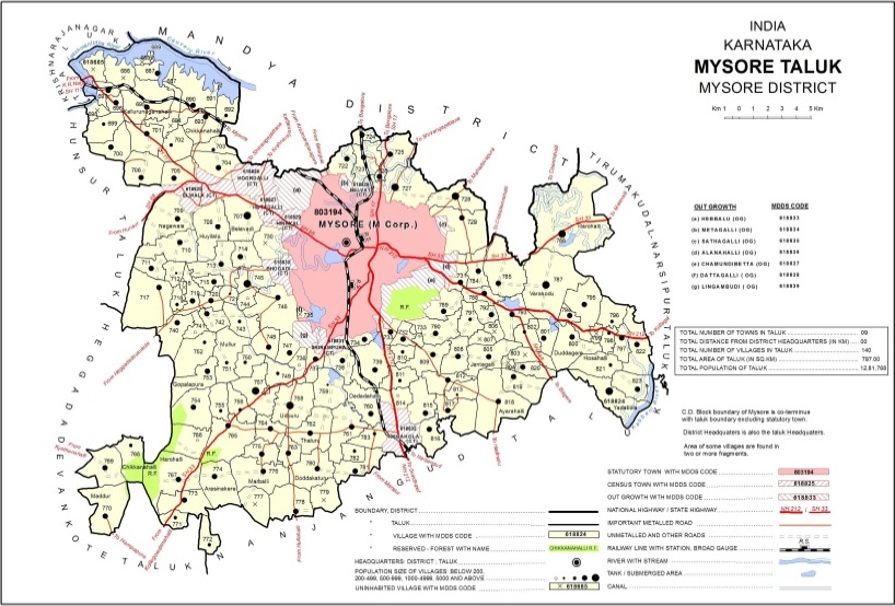
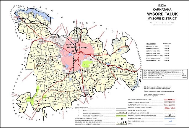
English: Mysore Taluk Map as per 2011 Census |
| Date | |
| Source | https://censusindia.gov.in/2011census/dchb/2923_PART_B_DCHB_MYSORE.pdf |
| Author | Directorate, Census India |
| Other versions |
.jpg)
_(cropped).jpg&action=edit§ion=1)
| Camera location | | View this and other nearby images on: OpenStreetMap |
|---|
_(cropped).jpg¶ms=012.304953_N_0076.654955_E_globe:Earth_type:camera__&language=en)
Licensing[edit]
_(cropped).jpg&action=edit§ion=2)

|
This file is a copyrighted work of the Government of India, licensed under the Government Open Data License - India (GODL).
Information on Related Items:
|
 |
|
|

|
This image, which was originally posted in the source indicated above, has not yet been reviewed by an administrator or reviewer to confirm that the above license is valid. See Category:Unreviewed photos of GODL-India for further instructions.
|
File history
Click on a date/time to view the file as it appeared at that time.
| Date/Time | Thumbnail | Dimensions | User | Comment | |
|---|---|---|---|---|---|
| current | 14:05, 21 September 2022 | | 818 × 554 (167 KB) | User-duck (talk | contribs) | File:Mysore Taluk (2011 Census).jpg cropped border using CropTool with lossless mode. |
You cannot overwrite this file.
File usage on Commons
The following page uses this file:
File usage on other wikis
The following other wikis use this file:
- Usage on en.wikipedia.org
_(cropped).jpg&oldid=696089271)