File:Nordmünchner Kanalsystem.png
(Redirected from File:NMKS.png)
Size of this preview: 603 × 599 pixels. Other resolutions: 242 × 240 pixels | 483 × 480 pixels | 934 × 928 pixels.
Original file (934 × 928 pixels, file size: 89 KB, MIME type: image/png)
Captions
Captions
Add a one-line explanation of what this file represents

|
This map image could be re-created using vector graphics as an SVG file. This has several advantages; see Commons:Media for cleanup for more information. If an SVG form of this image is available, please upload it and afterwards replace this template with
{{vector version available|new image name}}.
It is recommended to name the SVG file “Nordmünchner Kanalsystem.svg”—then the template Vector version available (or Vva) does not need the new image name parameter. |
Summary[edit]
| Description |
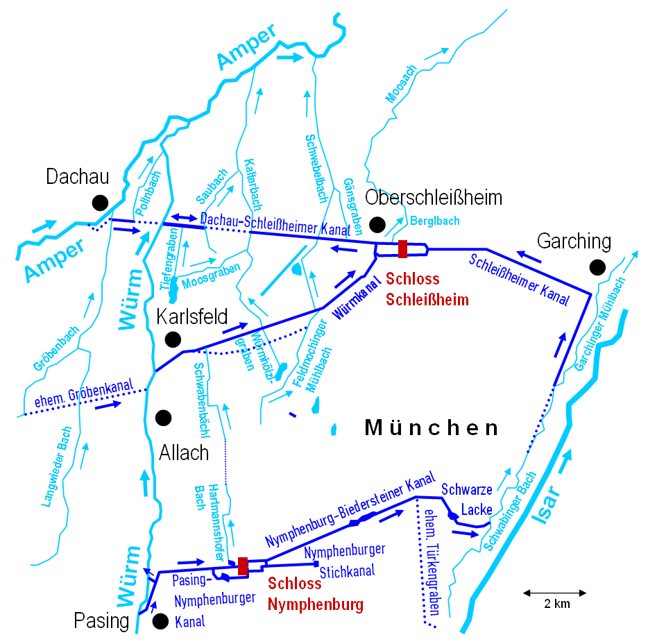
English: Northern Munich channel system (Germany, Bavaria)
Deutsch: Nordmünchner Kanalsystem (Bundesrepublik Deutschland, Bayern). Trockengelegte und weitgehend auch verfüllte Kanalabschnitte sind punktiert dargestellt. |
| Date | |
| Source | Own work traced from official map https://geoportal.bayern.de/bayernatlas |
| Author | Periphrastika |
Licensing[edit]
| I, the copyright holder of this work, release this work into the public domain. This applies worldwide. In some countries this may not be legally possible; if so: I grant anyone the right to use this work for any purpose, without any conditions, unless such conditions are required by law. |
Original upload log[edit]
The original description page was here. All following user names refer to de.wikipedia.
- 2009-09-10 15:07 Periphrastika 934×928× (133374 bytes) {{Information |Beschreibung = Flüsse, Bäche und Kanäle im Bereich des Nordmünchner Kanalsystems |Quelle = selbst erstellt |Urheber = Periphrastika |Datum = 08.09.2009 |Genehmigung = |Andere Versionen = |Anmerkungen = }}
- 2009-09-10 14:24 Periphrastika 928×928× (131814 bytes) {{Information |Beschreibung = Flüsse, Bäche und Kanäle im Bereich des Nordmünchner Kanalsystems |Quelle = selbst erstellt |Urheber = Periphrastika |Datum = 10.09.2009 |Genehmigung = |Andere Versionen = |Anmerkungen = }}
File history
Click on a date/time to view the file as it appeared at that time.
| Date/Time | Thumbnail | Dimensions | User | Comment | |
|---|---|---|---|---|---|
| current | 10:50, 19 June 2014 | | 934 × 928 (89 KB) | Kopiersperre (talk | contribs) | optipng |
| 09:05, 18 September 2009 |  | 934 × 928 (130 KB) | Periphrastika (talk | contribs) | {{Information |Description={{en|1=Northern Munich channel system (Germany, Bavaria)}} {{de|1=Nordmünchner Kanalsystem (Bundesrepublik Deutschland, Bayern)}} |Source=Eigenes Werk (own work) |Author=Periphrastika |Date=2009-08-25 |Pe |
You cannot overwrite this file.
File usage on Commons
The following 3 pages use this file:
- File:NMKS.png (file redirect)
- Category:Moosgraben (Kalterbach)
- Category:Würmkanal
File usage on other wikis
The following other wikis use this file:
- Usage on bg.wikipedia.org
- Usage on de.wikipedia.org
- Usage on www.wikidata.org