File:NPS acadia-bedrock-geology-map.jpg
Jump to navigation
Jump to search

Size of this preview: 526 × 600 pixels. Other resolutions: 210 × 240 pixels | 421 × 480 pixels | 673 × 768 pixels | 898 × 1,024 pixels | 1,796 × 2,048 pixels | 3,244 × 3,700 pixels.
Original file (3,244 × 3,700 pixels, file size: 1.31 MB, MIME type: image/jpeg)
Captions
Captions
Add a one-line explanation of what this file represents
Summary[edit]
| Description |
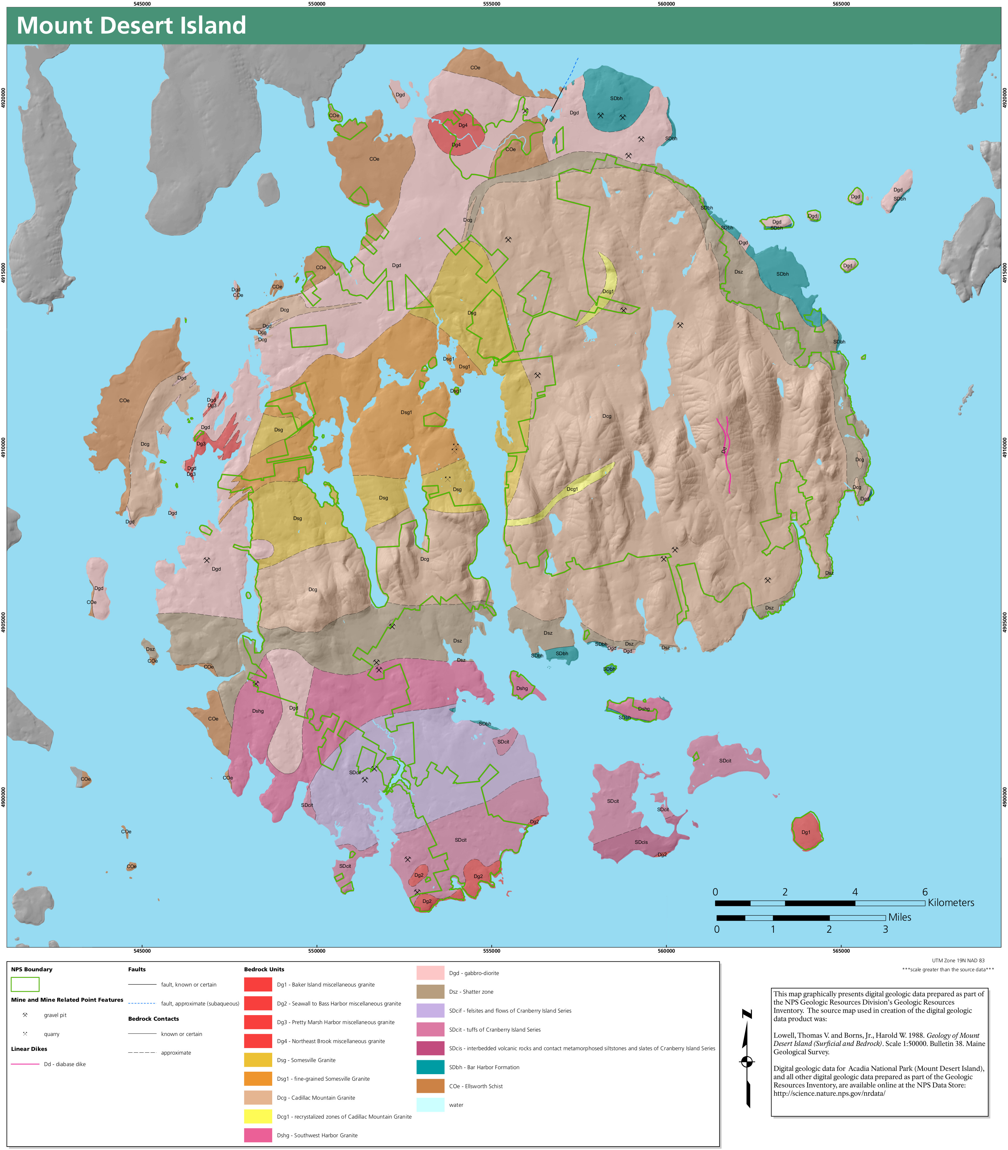
English: Acadia bedrock geology map, showcasing the variety of granites and other rocks that make up the bedrock of Mount Desert Island. Now’s your chance to learn about that pink granite! |
| Date | |
| Source | U.S. National Park Service (http://npmaps.com/wp-content/uploads/acadia-bedrock-geology-map.jpg) |
| Author | U.S. National Park Service, restoration/cleanup by Matt Holly |
Licensing[edit]
| This image or media file contains material based on a work of a National Park Service employee, created as part of that person's official duties. As a work of the U.S. federal government, such work is in the public domain in the United States. See the NPS website and NPS copyright policy for more information. |
File history
Click on a date/time to view the file as it appeared at that time.
| Date/Time | Thumbnail | Dimensions | User | Comment | |
|---|---|---|---|---|---|
| current | 06:32, 12 May 2017 | | 3,244 × 3,700 (1.31 MB) | RKBot (talk | contribs) | =={{int:filedesc}}== {{Information |description= {{en|1=Acadia bedrock geology map, showcasing the variety of granites and other rocks that make up the bedrock of Mount Desert Island. Now’s your chance to learn about that pink granite!}} |date= 2017-... |
You cannot overwrite this file.
File usage on Commons
The following page uses this file:
Categories:
- Geological maps of Acadia National Park
- Geological maps of Maine
- Bedrock geology of the United States
- Quarries in Maine
- Faults in Maine
- Granite formations of Baker Island
- Granite formations of Bass Harbor
- Granite formations of Pretty Marsh Harbor
- Granite formations of Northeast Brook
- Bedrock in the United States
- Somesville Granite
- Cadillac Mountain Granite
- Southwest Harbor Granite
- Gabbro-diorite formations in Maine
- Cranberry Island Series
- Felsic rocks of the Cranberry Island Series
- Tuffs of the Carnberry Island Series
- Metamorphic sedimentary rocks of the Carnberry Island Series
- Bar Harbor Formation
- Ellsworth Schist
- Volcanological maps of the United States
- Shatter Zone (geologic formation)
- Bedrock in Maine