File:NPS wupatki-geologic-map-overview.jpg
Jump to navigation
Jump to search

Size of this preview: 800 × 442 pixels. Other resolutions: 320 × 177 pixels | 640 × 354 pixels | 1,024 × 566 pixels | 1,280 × 707 pixels | 2,560 × 1,415 pixels | 4,546 × 2,512 pixels.
Original file (4,546 × 2,512 pixels, file size: 2.01 MB, MIME type: image/jpeg)
Captions
Captions
Add a one-line explanation of what this file represents
Summary
[edit]
| Description |
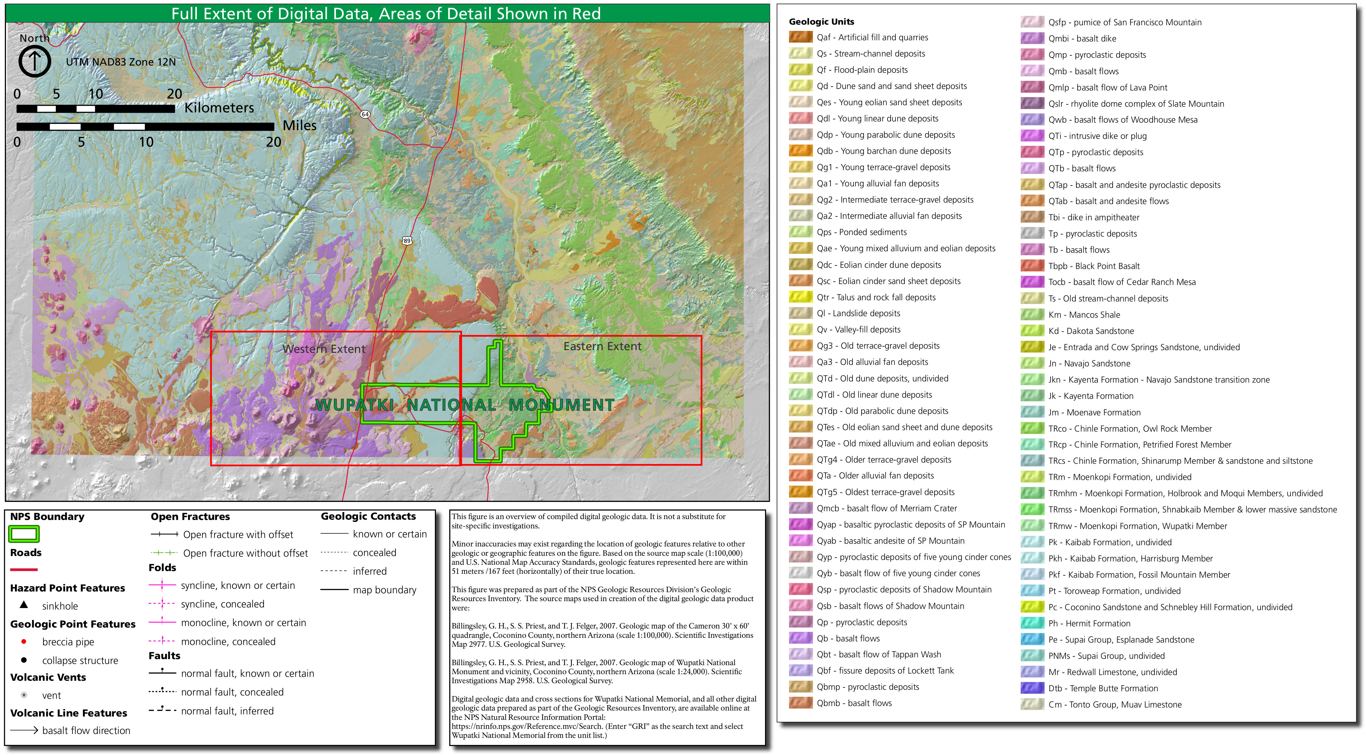
English: Wupatki geologic overview map, providing a legend for the two geologic maps to follow. These are some incredibly detailed maps! Some of the best NPS geologic maps I’ve ever seen. |
| Date | |
| Source | U.S. National Park Service (http://npmaps.com/wp-content/uploads/wupatki-geologic-map-overview.jpg) |
| Author | U.S. National Park Service, restoration/cleanup by Matt Holly |
Licensing
[edit]
| This image or media file contains material based on a work of a National Park Service employee, created as part of that person's official duties. As a work of the U.S. federal government, such work is in the public domain in the United States. See the NPS website and NPS copyright policy for more information. |
File history
Click on a date/time to view the file as it appeared at that time.
| Date/Time | Thumbnail | Dimensions | User | Comment | |
|---|---|---|---|---|---|
| current | 10:04, 17 May 2017 | | 4,546 × 2,512 (2.01 MB) | RKBot (talk | contribs) | =={{int:filedesc}}== {{Information |description= {{en|1=Wupatki geologic overview map, providing a legend for the two geologic maps to follow. These are some incredibly detailed maps! Some of the best NPS geologic maps I’ve ever seen.}} |date= 2017-0... |
You cannot overwrite this file.
File usage on Commons
The following page uses this file:
Categories:
- Geological maps of Wupatki National Monument
- Geological maps of Arizona
- Geological maps of the San Francisco Volcanic Field
- Volcanological maps of Arizona
- Quaternary artificial fill in Arizona
- Quaternary stream channel deposits in Arizona
- Quaternary floodplain deposits in Arizona
- Quaternary dune sand in Arizona
- Quaternary sand sheet deposits in Arizona
- Quaternary linear dune deposits in Arizona
- Quaternary barchan dune deposits in Arizona
- Quaternary parabolic dune deposits in Arizona
- Quaternary terrace gravel deposits in Arizona
- Quaternary alluvial fan deposits in Arizona
- Quaternary alluvium in Arizona
- Quaternary aeolian deposits in Arizona
- Quaternary aeolian cinder dune deposits in Arizona
- Quaternary aeolian cinder sand sheet deposits in Arizona
- Quaternary talus in Arizona
- Quaternary rock fall deposits in Arizona
- Quaternary landslide deposits in Arizona
- Quaternary valley-fill deposits in Arizona
- Basalt flow of Merriam Crater
- Basaltic pyroclastic deposits of SP Mountain
- Basaltic andesite of SP Mountain
- Quaternary pyroclastic deposits in Arizona
- Quaternary basalt flows in Arizona
- Quaternary pyroclastic deposits of Shadow Mountain
- Quaternary basalt flows of Shadow Mountain
- Basalt flow of Tappan Wash
- Fissure deposits of Lockett Tank
- Quaternary pumice of San Francisco Mountain
- Quaternary basalt dikes in Arizona
- Basalt flow of Lava Point
- Rhyolitic dome complex of Slate Mountain
- Basalt flows of Woodhouse Mesa
- Neogene basalt pyroclastic deposits of San Francisco Volcanic Field
- Neogene andesite pyroclastic deposits of San Francisco Volcanic Field
- Neogene basalt flows of San Francisco Volcanic Field
- Neogene andesite flows of San Francisco Volcanic Field
- Paleogene pyroclastic deposits in Arizona
- Paleogene basalt flows in Arizona
- Black Point Basalt
- Basalt flow of Cedar Ranch Mesa
- Mancos Shale in Arizona
- Mancos Shale maps
- Dakota Sandstone in Arizona
- Dakota Formation - maps
- Entrada Sandstone in Arizona
- Entrada Sandstone maps
- Cow Springs Sandstone
- Navajo Sandstone maps
- Navajo Sandstone in Arizona
- Kayenta Formation - maps
- Kayenta Formation in Arizona
- Moenave Formation - maps
- Moenave Formation in Arizona
- Owl Rock Member - maps
- Owl Rock Member
- Petrified Forest Member - maps
- Petrified Forest Member in Arizona
- Shinarump Conglomerate - maps
- Shinarump Conglomerate in Arizona
- Moenkopi Formation in Arizona
- Moenkopi Formation maps
- Holbrook Member, Moenkopi Formation
- Moqui Member, Moenkopi Formation
- Shnabkaib Member, Moenkopi Formation
- Wupatki Member, Moenkopi Formation
- Kaibab Limestone in Arizona
- Kaibab Limestone maps
- Harrisburg Member, Kaibab Formation
- Fossil Mountain Member, Kaibab Formation
- Toroweap Formation - maps
- Toroweap Formation in Arizona
- Coconino Sandstone - maps
- Coconino Sandstone in Arizona
- Schnebly Hill Formation
- Hermit Formation - maps
- Hermit Formation in Arizona
- Esplanade Sandstone - maps
- Supai Group
- Redwall Limestone - maps
- Temple Butte Formation - maps
- Muav Limestone - maps