File:Nacurh-hosts.png
Jump to navigation
Jump to search
No higher resolution available.
Nacurh-hosts.png (402 × 242 pixels, file size: 12 KB, MIME type: image/png)
Captions
Captions
Add a one-line explanation of what this file represents
Summary[edit]

|
This map image could be re-created using vector graphics as an SVG file. This has several advantages; see Commons:Media for cleanup for more information. If an SVG form of this image is available, please upload it and afterwards replace this template with
{{vector version available|new image name}}.
It is recommended to name the SVG file “Nacurh-hosts.svg”—then the template Vector version available (or Vva) does not need the new image name parameter. |
| Description |
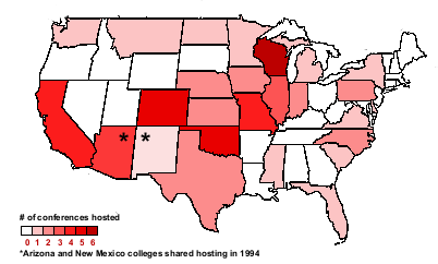
English: Map showing distribution of NACURH host schools aggregated by state. Each state is shaded progressively to reflect the number of times a school (or schools) in that state have hosted the NACURH national conference. Two states are median-shaded to reflect that schools in both states once co-hosted the same conference. The data comes from the NACURH article. |
| Date | 17 November 2006 (original upload date) |
| Source | Original, using freely-reusable [1] outline map |
| Author | Keith D. Tyler ¶ (AMA) |
| Permission (Reusing this file) |
Creative Commons |
Licensing[edit]
This file is licensed under the Creative Commons Attribution 2.0 Generic license.
- You are free:
- to share – to copy, distribute and transmit the work
- to remix – to adapt the work
- Under the following conditions:
- attribution – You must give appropriate credit, provide a link to the license, and indicate if changes were made. You may do so in any reasonable manner, but not in any way that suggests the licensor endorses you or your use.
Original upload log[edit]
Transferred from en.wikipedia to Commons by Dharmadhyaksha using CommonsHelper.
The original description page was here. All following user names refer to en.wikipedia.
- 2007-06-12 16:35 KeithTyler 402×242× (12334 bytes) updated to reflect 2008 conference host
- 2006-11-17 06:49 KeithTyler 402×242× (12332 bytes) Map showing distribution of NACURH host schools aggregated by state. Uses portions of the North American outline map from [http://www.worldatlas.com/webimage/countrys/namerica/naoutl.htm] which does not require permission for reuse. {{CC-by-2.0}}
File history
Click on a date/time to view the file as it appeared at that time.
| Date/Time | Thumbnail | Dimensions | User | Comment | |
|---|---|---|---|---|---|
| current | 08:29, 5 February 2013 | | 402 × 242 (12 KB) | File Upload Bot (Magnus Manske) (talk | contribs) | Transfered from en.wikipedia by User:Dharmadhyaksha using CommonsHelper |
You cannot overwrite this file.
File usage on Commons
There are no pages that use this file.