File:Nanga Parbat 1953 map.svg

Original file (SVG file, nominally 756 × 924 pixels, file size: 108 KB)
Captions
Captions
Summary[edit]
| Description |
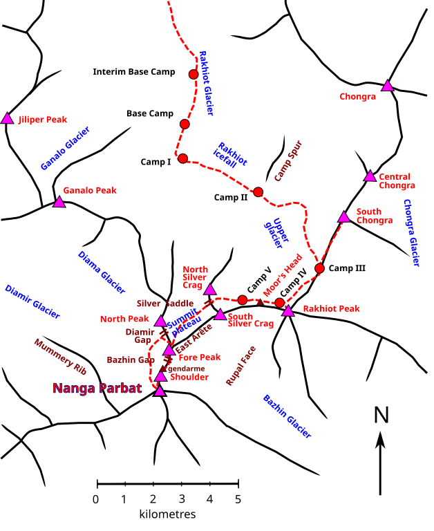
English: Sketch map of 1953 French Nanga Parbat expedition |
| Date | |
| Source | Own work |
| Author | Thincat |
| Other versions | File:Nanga Parbat 1953 map 01.png |
| Camera location | | View this and other nearby images on: OpenStreetMap |
|---|
Alternative names of features
North Silver Crag: Silberzacken, East Peak
South Silberzacken: Southeast Peak
Silbersattel: Silver Saddle
Fore Peak: Subsidiary summit
Summit plateau: Silver Plateau
East Arête extends from Nanga Parbat to Rakhiot Peak
Map based on maps in
Buhl, Hermann (1956). Nanga Parbat Pilgrimage [Achttausend: drüber und drunter]. Translated by Merrick, Hugh. London: Hodder and Stoughton. – reprinted in US as Buhl, Hermann (1956). Lonely Challenge. E.P. Dutton.
and
Baume, Louis Charles (1979). Sivalaya: explorations of the 8000-metre peaks of the Himalaya. Seattle : Mountaineers. ISBN 978-0-916890-97-1.
Licensing[edit]
- You are free:
- to share – to copy, distribute and transmit the work
- to remix – to adapt the work
- Under the following conditions:
- attribution – You must give appropriate credit, provide a link to the license, and indicate if changes were made. You may do so in any reasonable manner, but not in any way that suggests the licensor endorses you or your use.
- share alike – If you remix, transform, or build upon the material, you must distribute your contributions under the same or compatible license as the original.
File history
Click on a date/time to view the file as it appeared at that time.
| Date/Time | Thumbnail | Dimensions | User | Comment | |
|---|---|---|---|---|---|
| current | 17:45, 15 February 2021 | | 756 × 924 (108 KB) | Thincat (talk | contribs) | Correct detail of descent route |
| 15:55, 13 February 2021 |  | 756 × 924 (107 KB) | Thincat (talk | contribs) | East Arete | |
| 15:39, 13 February 2021 |  | 756 × 924 (1.07 MB) | Thincat (talk | contribs) | Uploaded own work with UploadWizard |
You cannot overwrite this file.
File usage on Commons
There are no pages that use this file.