File:Neufrankreich.svg
Jump to navigation
Jump to search

Size of this PNG preview of this SVG file: 800 × 570 pixels. Other resolutions: 320 × 228 pixels | 640 × 456 pixels | 1,024 × 730 pixels | 1,280 × 912 pixels | 2,560 × 1,824 pixels | 1,530 × 1,090 pixels.
Original file (SVG file, nominally 1,530 × 1,090 pixels, file size: 694 KB)
Captions
Captions
Add a one-line explanation of what this file represents
Summary
[edit]| Description |
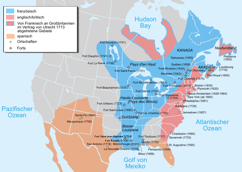
Català: Mapa de la Nova França sobre 1754-1755 English: Map of New France about 1750 using modern political boundaries Español: Mapa de la Nueva Francia cerca de 1750. Français : Carte de la Nouvelle-France vers 1754-1755 Norsk nynorsk: Kart over Ny Frankrike (ca 1754-1755) Русский: Карта Французских колоний в Америке 1750 中文(中国大陆): 1750年左右的新法兰西地图,附现代边界。 العربية : خريطة فرنسا الجديدة حوالي عام 1750 باستخدام الحدود السياسية الحديثة |
||
| Date | (UTC) | ||
| Source |
This file was derived from:
EquiDistantConicProjection : Central parallel : * N: 37.0° N Central meridian : * E: 96.0° W Standard parallels: * 1: 32.0° N * 2: 42.0° N Made with Natural Earth. Free vector and raster map data @ naturalearthdata.com. Formulas for x and y: x = 50.0 + 124.03149777329222 * ((1.9694462586094064-({{{2}}}* pi / 180)) * sin(0.6010514667026994 * ({{{3}}} + 96) * pi / 180)) y = 50.0 + 1.6155950752393982 * 124.03149777329222 * 0.02613325650382181 - 1.6155950752393982 * 124.03149777329222 * (1.3236744353715044 - (1.9694462586094064-({{{2}}}* pi / 180)) * cos(0.6010514667026994 * ({{{3}}} + 96) * pi / 180))
|
||
| Author |
|
||
| Other versions |
[]
|


| This is a retouched picture, which means that it has been digitally altered from its original version. Modifications: added Mexico, translated to German. The original can be viewed here: Usa edcp location map.svg:
|
Licensing
[edit]
This file is licensed under the Creative Commons Attribution-Share Alike 3.0 Unported license.
- You are free:
- to share – to copy, distribute and transmit the work
- to remix – to adapt the work
- Under the following conditions:
- attribution – You must give appropriate credit, provide a link to the license, and indicate if changes were made. You may do so in any reasonable manner, but not in any way that suggests the licensor endorses you or your use.
- share alike – If you remix, transform, or build upon the material, you must distribute your contributions under the same or compatible license as the original.
Original upload log
[edit]
This image is a derivative work of the following images:
- File:Nouvelle-France_map-fr.svg licensed with Cc-by-sa-3.0,2.5,2.0,1.0, GFDL
- 2011-12-03T22:43:05Z JF Lepage 1530x1090 (333614 Bytes) Reverted to version as of 18:04, 13 November 2007
- 2011-12-01T12:21:39Z Hypersite 1550x1100 (348037 Bytes) Agrandie
- 2011-12-01T12:19:24Z Hypersite 1530x1090 (348037 Bytes) Agrandie
- 2011-12-01T12:15:49Z Hypersite 744x1052 (347994 Bytes) Vraie taille de la Nouvelle-France, Version améliorée,Ajout de 80 sources pour un délimitation des frontière la plus exacte possible. (Quand a la polémique disant que sont territoire s'étendait jusque en Oregon et Oc�
- 2011-12-01T12:12:54Z Hypersite 744x1052 (347978 Bytes) Vraie taille de la Nouvelle-France, Version améliorée,Ajout de 80 sources pour un délimitation des frontière la plus exacte possible. (Quand a la polémique disant que sont territoire s'étendait jusque en Oregon et Oc�
- 2007-11-13T18:04:41Z Pinpin 1530x1090 (333614 Bytes) illinois=>Illinois
- 2007-10-20T08:10:28Z Pinpin 1530x1090 (333613 Bytes)
- 2007-10-10T18:59:28Z Pinpin 1530x1090 (333619 Bytes)
- 2007-10-10T07:48:33Z Pinpin 1530x1090 (333620 Bytes)
- 2007-10-05T06:26:34Z Pinpin 1530x1090 (333485 Bytes)
- 2007-10-04T23:51:17Z Pinpin 1530x1090 (334013 Bytes)
- 2007-10-04T23:49:21Z Pinpin 1530x1090 (334112 Bytes) + legend
- 2007-10-04T23:38:23Z Pinpin 1530x1090 (326455 Bytes) {{Information |Description={{fr|Carte de la Nouvelle-France vers 1750}} {{en|Map of the New-France about 1750.}} |Source=travail personnel from [[:Image:Nouvelle-France1750.png]] 1)Les Villes françaises du Nouveau Monde : de
- File:Usa_edcp_location_map.svg licensed with Cc-by-sa-3.0, GFDL
- 2010-08-24T17:56:50Z Uwe Dedering 1181x731 (2691477 Bytes) coastline was to thin and bahamas pulled out of the atlantic
- 2010-08-24T10:35:14Z Uwe Dedering 1181x731 (3648408 Bytes) {{Information |Description={{en|1=Location map of the USA (without Hawaii and Alaska). EquiDistantConicProjection : Central parallel : * N: 37.0° N Central meridian : * E: 96.0° W Standard parallels: * 1: 32.0° N * 2:
Uploaded with derivativeFX
File history
Click on a date/time to view the file as it appeared at that time.
| Date/Time | Thumbnail | Dimensions | User | Comment | |
|---|---|---|---|---|---|
| current | 16:12, 14 December 2022 | | 1,530 × 1,090 (694 KB) | Tcr25 (talk | contribs) | Fort Rosaile in wrong location; add Fort St-Jean-Baptiste |
| 00:20, 9 October 2013 |  | 1,530 × 1,090 (924 KB) | Furfur (talk | contribs) | Schraffur ist verlorengegangen, stattdessen vielleicht Umrandung ? | |
| 23:31, 8 October 2013 |  | 1,530 × 1,090 (902 KB) | Furfur (talk | contribs) | kosmetische Änderungen (Diskussion Kartenwerkstatt) | |
| 14:14, 31 January 2012 |  | 1,530 × 1,090 (316 KB) | Bamse (talk | contribs) | update per comments in Kartenwerkstatt | |
| 20:40, 29 January 2012 |  | 1,530 × 1,090 (316 KB) | Bamse (talk | contribs) | error fixes per discussion in Kartenwerkstatt | |
| 21:05, 28 January 2012 |  | 1,530 × 1,090 (316 KB) | Bamse (talk | contribs) | extended Spain to Mexico, added some towns and fixed some errors | |
| 10:54, 28 January 2012 |  | 1,530 × 1,090 (307 KB) | Bamse (talk | contribs) | == {{int:filedesc}} == {{Information |Description={{fr|Carte de la Nouvelle-France vers 1750 - version française}} {{en|Map of the New-France about 1750 - French Version}} {{en|1=Location map of the USA (without Hawaii and Alaska). EquiDistantConicProjec |
You cannot overwrite this file.
File usage on Commons
The following 12 pages use this file:
- File:Neufrankreich.svg
- File:Nouvelle-France map-ar.svg
- File:Nouvelle-France map-ca.svg
- File:Nouvelle-France map-en.svg
- File:Nouvelle-France map-es.svg
- File:Nouvelle-France map-fr.svg
- File:Nouvelle-France map-he.svg
- File:Nouvelle-France map-ru.svg
- File:Nouvelle-France map-zh-hans.svg
- File:USA edcp location map lite.svg
- File:Usa edcp location map.svg
- Template:Other versions/Nouvelle-France map
File usage on other wikis
The following other wikis use this file:
- Usage on de.wikipedia.org
- Shawnee
- Neufrankreich
- Louisiana (Kolonie)
- Miami (Volk)
- Indianerkriege
- Siebenjähriger Krieg in Nordamerika
- Onondaga
- Fort Michilimackinac
- Winnebago (Volk)
- Geschichte Québecs
- Wirtschaftsgeschichte Kanadas
- Geschichte Louisianas
- Wikipedia:Kartenwerkstatt/Archiv/2012-02
- Menominee (Volk)
- Wikipedia:Kartenwerkstatt/Archiv/2013-10
- Schweizer Truppen in französischen Diensten für das Königshaus der Bourbonen 1589–1792
- The Jesuit Relations and Allied Documents
- Beziehungen zwischen Kanada und den Vereinigten Staaten
- Usage on en.wikipedia.org
- Usage on hy.wikipedia.org
- Usage on it.wikipedia.org
Metadata
Categories:
- Maps of New France
- Maps of colonial North America
- Maps of the history of Canada
- Maps of the history of the United States
- Maps of the Viceroyalty of New Spain
- SVG maps of the history of Mexico
- Locator maps of former territories
- North America in the 1750s
- Canada in the 1750s
- United States in the 1750s
- New Mexico in the 1750s
- French and Indian War
- Treaty of Utrecht