File:Neuhofen ad Krems Birke am Guglberg-2428.jpg
Original file (5,028 × 3,771 pixels, file size: 12.3 MB, MIME type: image/jpeg)
Captions
Summary
[edit]DescriptionNeuhofen ad Krems Birke am Guglberg-2428.jpg |
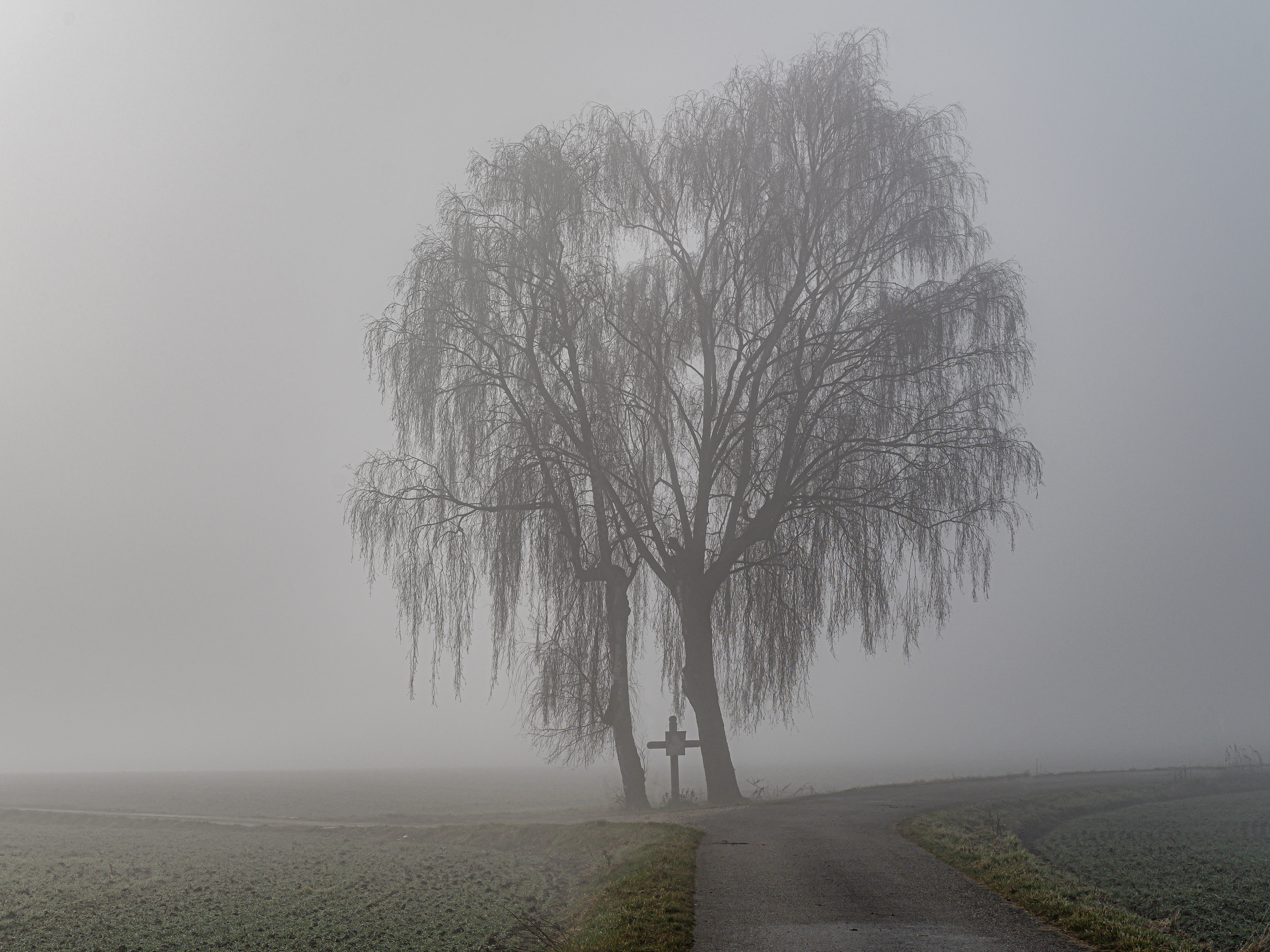
Deutsch: Am höchsten Punkt des Guglbergs, einer Erhebung mit einer Höhe von 365 m.ü.A. in Neuhofen an der Krems, steht ein Wegkreuz unter zwei Birken.
English: At the highest point of Guglberg, an elevation of 365 meters above sea level in Neuhofen an der Krems, there is a wayside cross under two birch trees. |
Date | |
Source | Own work |
Author | Isiwal |
Camera location | 48° 08′ 39.37″ N, 14° 11′ 32.39″ E | View this and other nearby images on: OpenStreetMap | 48.144270; 14.192330 |
---|
Licensing
[edit]- You are free:
- to share – to copy, distribute and transmit the work
- to remix – to adapt the work
- Under the following conditions:
- attribution – You must give appropriate credit, provide a link to the license, and indicate if changes were made. You may do so in any reasonable manner, but not in any way that suggests the licensor endorses you or your use.
- share alike – If you remix, transform, or build upon the material, you must distribute your contributions under the same or compatible license as the original.
Diese Datei wurde im Rahmen von WikiDaheim 2021 in Österreich erstellt und hochgeladen. Sie wurde dem allgemeinen Themenbereich zugeordnet. |
This image has been assessed using the Quality image guidelines and is considered a Quality image.
العربية ∙ جازايرية ∙ беларуская ∙ беларуская (тарашкевіца) ∙ български ∙ বাংলা ∙ català ∙ čeština ∙ Cymraeg ∙ Deutsch ∙ Schweizer Hochdeutsch ∙ Zazaki ∙ Ελληνικά ∙ English ∙ Esperanto ∙ español ∙ eesti ∙ euskara ∙ فارسی ∙ suomi ∙ français ∙ galego ∙ עברית ∙ हिन्दी ∙ hrvatski ∙ magyar ∙ հայերեն ∙ Bahasa Indonesia ∙ italiano ∙ 日本語 ∙ Jawa ∙ ქართული ∙ 한국어 ∙ kurdî ∙ Lëtzebuergesch ∙ lietuvių ∙ македонски ∙ മലയാളം ∙ मराठी ∙ Bahasa Melayu ∙ Nederlands ∙ Norfuk / Pitkern ∙ polski ∙ português ∙ português do Brasil ∙ rumantsch ∙ română ∙ русский ∙ sicilianu ∙ slovenčina ∙ slovenščina ∙ shqip ∙ српски / srpski ∙ svenska ∙ தமிழ் ∙ తెలుగు ∙ ไทย ∙ Tagalog ∙ toki pona ∙ Türkçe ∙ українська ∙ vèneto ∙ Tiếng Việt ∙ 中文 ∙ 中文(简体) ∙ 中文(繁體) ∙ +/− |
File history
Click on a date/time to view the file as it appeared at that time.
Date/Time | Thumbnail | Dimensions | User | Comment | |
---|---|---|---|---|---|
current | 18:52, 10 September 2021 | 5,028 × 3,771 (12.3 MB) | Isiwal (talk | contribs) | Uploaded own work with UploadWizard |
You cannot overwrite this file.
File usage on Commons
The following 4 pages use this file:
File usage on other wikis
The following other wikis use this file:
- Usage on de.wikipedia.org
Metadata
This file contains additional information such as Exif metadata which may have been added by the digital camera, scanner, or software program used to create or digitize it. If the file has been modified from its original state, some details such as the timestamp may not fully reflect those of the original file. The timestamp is only as accurate as the clock in the camera, and it may be completely wrong.
Camera manufacturer | NIKON CORPORATION |
---|---|
Camera model | NIKON Z 6 |
Exposure time | 1/800 sec (0.00125) |
F-number | f/8 |
ISO speed rating | 100 |
Date and time of data generation | 11:46, 31 December 2020 |
Lens focal length | 57 mm |
Latitude | 48° 8′ 39.39″ N |
Longitude | 14° 11′ 32.39″ E |
Altitude | 360 meters above sea level |
City shown | Neuhofen an der Krems |
Horizontal resolution | 300 dpi |
Vertical resolution | 300 dpi |
Software used | Adobe Photoshop Lightroom Classic 10.2 (Windows) |
File change date and time | 11:35, 28 March 2021 |
Exposure Program | Aperture priority |
Exif version | 2.31 |
Date and time of digitizing | 11:46, 31 December 2020 |
APEX shutter speed | 9.643856 |
APEX aperture | 6 |
APEX exposure bias | 0 |
Metering mode | Pattern |
Light source | Unknown |
Flash | Flash did not fire |
DateTimeOriginal subseconds | 94 |
DateTimeDigitized subseconds | 94 |
Color space | sRGB |
Focal plane X resolution | 1,683.0665283203 |
Focal plane Y resolution | 1,683.0665283203 |
Focal plane resolution unit | 3 |
Sensing method | One-chip color area sensor |
File source | Digital still camera |
Scene type | A directly photographed image |
Custom image processing | Custom process |
Exposure mode | Auto exposure |
White balance | Auto white balance |
Focal length in 35 mm film | 57 mm |
Scene capture type | Standard |
Scene control | None |
Contrast | Normal |
Saturation | Normal |
Sharpness | Normal |
Subject distance range | Unknown |
Direction of image | 180 |
GPS tag version | 0.0.2.2 |
Serial number of camera | 6079764 |
Lens used | NIKKOR Z 24-70mm f/2.8 S |
Date metadata was last modified | 13:35, 28 March 2021 |
Unique ID of original document | 26E3A46C9F30126C490F1739559ACEF9 |
Province or state shown | Oberösterreich |
Country shown | Österreich |
Code for country shown | AT |
IIM version | 4 |
Structured data
Items portrayed in this file
depicts
48°8'39.37"N, 14°11'32.39"E
0.00125 second
57 millimetre
100
31 December 2020
image/jpeg
- Files with coordinates missing SDC location of creation
- CC-BY-SA-4.0
- Self-published work
- Media from WikiDaheim 2021 in Austria/all
- Media from WikiDaheim 2021 in Austria/Unspecified
- Media from WikiDaheim in Austria check done
- Uploaded via Campaign:WikiDaheim-at
- Quality images supported by Wikimedia Österreich in 2021
- Quality images of Upper Austria
- Quality images by Isiwal
- Quality images
- Austria photographs taken on 2020-12-31