File:Newport UK map roads and areas 3m1.svg
Jump to navigation
Jump to search

Size of this PNG preview of this SVG file: 693 × 600 pixels. Other resolutions: 277 × 240 pixels | 555 × 480 pixels | 888 × 768 pixels | 1,184 × 1,024 pixels | 2,367 × 2,048 pixels | 1,425 × 1,233 pixels.
Original file (SVG file, nominally 1,425 × 1,233 pixels, file size: 482 KB)
Captions
Captions
Add a one-line explanation of what this file represents
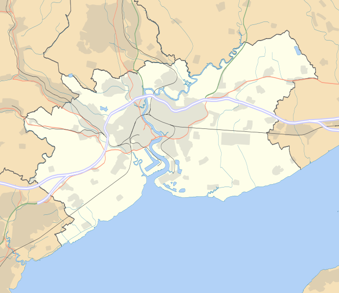
| Description | Map of Newport, UK with the following data shown: *Administrative borders *Coastline, lakes and rivers *Motorways, primary routes and A-roads *Railways *Urban areas Equirectangular map projection on WGS 84 datum, with N/S stretched 160% Geographic limits: *West: 3.15W *East: 2.78W *North: 51.67N *South: 51.47N Colours are the WM-wide convention for location maps. |
| Date | (UTC) |
| Source | |
| Author |
|
| This is a retouched picture, which means that it has been digitally altered from its original version. Modifications: Changed Motorway outer:inner id path878:path979 stroke from #8397f4:#95e6f3 to #6666ff:#ffffff and stroke-width from 4:3 to 5:3. The original can be viewed here: Newport UK map roads and areas 3.svg:
|
I, the copyright holder of this work, hereby publish it under the following license:
This file is licensed under the Creative Commons Attribution 3.0 Unported license.
- You are free:
- to share – to copy, distribute and transmit the work
- to remix – to adapt the work
- Under the following conditions:
- attribution – You must give appropriate credit, provide a link to the license, and indicate if changes were made. You may do so in any reasonable manner, but not in any way that suggests the licensor endorses you or your use.
Original upload log[edit]
This image is a derivative work of the following images:
- File:Newport_UK_map_roads_and_areas_3.svg licensed with Cc-by-3.0
- 2010-08-01T13:43:00Z Nilfanion 1425x1233 (493726 Bytes) thicker A roads, darker rail
- 2010-08-01T13:23:41Z Nilfanion 1425x1233 (493726 Bytes) {{Information |Description=Map of [[w:Newport|Newport]], UK with the following data shown: *Administrative borders *Coastline, lakes and rivers *Motorways, primary routes and A-roads *Railways *Urban areas Equirectangular ma
Uploaded with derivativeFX
File history
Click on a date/time to view the file as it appeared at that time.
| Date/Time | Thumbnail | Dimensions | User | Comment | |
|---|---|---|---|---|---|
| current | 14:14, 4 August 2010 | | 1,425 × 1,233 (482 KB) | Richardguk (talk | contribs) | Changed Motorway outer id path878 stroke from #6666ff to #ccccff stroke-width from 5 to 9 trying to make lower-resolution renderings look less like a river |
| 13:48, 4 August 2010 |  | 1,425 × 1,233 (482 KB) | Richardguk (talk | contribs) | {{Information |Description=Map of Newport, UK with the following data shown: *Administrative borders *Coastline, lakes and rivers *Motorways, primary routes and A-roads *Railways *Urban areas Equirectangular map projection on WGS 84 datum, |
You cannot overwrite this file.
File usage on Commons
There are no pages that use this file.
File usage on other wikis
The following other wikis use this file:
- Usage on en.wikipedia.org