File:Niger Delta Sealevel Stand.PNG
Jump to navigation
Jump to search
Size of this preview: 800 × 526 pixels. Other resolutions: 320 × 210 pixels | 640 × 421 pixels | 817 × 537 pixels.
Original file (817 × 537 pixels, file size: 422 KB, MIME type: image/png)
Captions
Captions
Add a one-line explanation of what this file represents
Summary
[edit]
| Description |
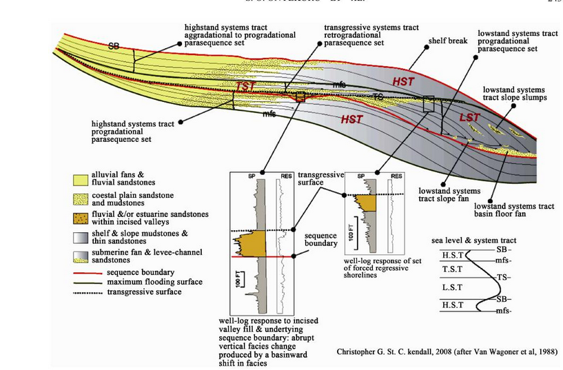
English: Figure 3. Sealevel highstand and lowstand mapped on a crossection of the basin |
| Date | |
| Source | Sequence Stratigraphic Analysis of "XB Field", Central Swamp Depobelt, Niger Delta Basin, Southern , Nigeria |
| Author | Samuel Okechukwu Onyekuru*, Emmanuel Chukwudi Ibelegbu, Julian Chukwuma Iwuagwu, Akan Godfrey Essien, Casmir Zanders Akaolisa |
Licensing
[edit]
This file is licensed under the Creative Commons Attribution 4.0 International license.
- You are free:
- to share – to copy, distribute and transmit the work
- to remix – to adapt the work
- Under the following conditions:
- attribution – You must give appropriate credit, provide a link to the license, and indicate if changes were made. You may do so in any reasonable manner, but not in any way that suggests the licensor endorses you or your use.
File history
Click on a date/time to view the file as it appeared at that time.
| Date/Time | Thumbnail | Dimensions | User | Comment | |
|---|---|---|---|---|---|
| current | 12:25, 6 March 2015 | | 817 × 537 (422 KB) | Arobi58 (talk | contribs) | User created page with UploadWizard |
You cannot overwrite this file.
File usage on Commons
There are no pages that use this file.
File usage on other wikis
The following other wikis use this file:
- Usage on en.wikipedia.org