File:Norfolk and Portsmouth Belt Line Railroad map 1947.jpg
Jump to navigation
Jump to search

Size of this preview: 379 × 599 pixels. Other resolutions: 152 × 240 pixels | 304 × 480 pixels | 486 × 768 pixels | 648 × 1,024 pixels | 1,297 × 2,048 pixels | 5,100 × 8,054 pixels.
Original file (5,100 × 8,054 pixels, file size: 19.2 MB, MIME type: image/jpeg)
Captions
Captions
Add a one-line explanation of what this file represents
Summary[edit]
| Description |
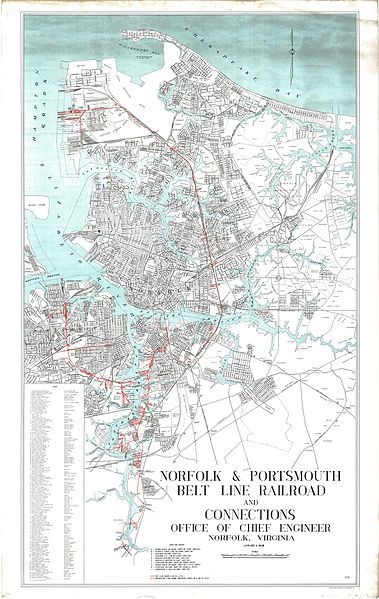
English: A system map of the Norfolk and Portsmouth Belt Line Railroad, it's interchanges and surrounding municipalities. |
| Date | |
| Source | Photoshop stitch of public domain map. |
| Author | Columbia Planograph Company; Washington D.C. |
Licensing[edit]
This work is in the public domain in the United States because it is a work prepared by an officer or employee of the United States Government as part of that person’s official duties under the terms of Title 17, Chapter 1, Section 105 of the US Code.
Note: This only applies to original works of the Federal Government and not to the work of any individual U.S. state, territory, commonwealth, county, municipality, or any other subdivision. This template also does not apply to postage stamp designs published by the United States Postal Service since 1978. (See § 313.6(C)(1) of Compendium of U.S. Copyright Office Practices). It also does not apply to certain US coins; see The US Mint Terms of Use.
|
 | |
| This file has been identified as being free of known restrictions under copyright law, including all related and neighboring rights. | ||
File history
Click on a date/time to view the file as it appeared at that time.
| Date/Time | Thumbnail | Dimensions | User | Comment | |
|---|---|---|---|---|---|
| current | 06:28, 10 January 2017 | | 5,100 × 8,054 (19.2 MB) | Dcgeorge76 (talk | contribs) | User created page with UploadWizard |
You cannot overwrite this file.
File usage on Commons
The following page uses this file:
File usage on other wikis
The following other wikis use this file:
- Usage on en.wikipedia.org
Metadata
Categories:
- Rail transport maps of Virginia
- Norfolk, Virginia
- Portsmouth, Virginia
- Maps of Chesapeake, Virginia
- Elizabeth River (Virginia)
- Norfolk Naval Shipyard in the 1940s
- Atlantic Coast Line Railroad
- Seaboard Air Line Railroad
- Virginian Railway
- Norfolk Southern Railway
- Norfolk and Western Railway
- Atlantic and Danville Railway
- Maps of the Pennsylvania Railroad
- Hampton Roads
- History of Hampton Roads