File:Northern Pacific Railroad map circa 1900.jpg
Jump to navigation
Jump to search

Size of this preview: 800 × 304 pixels. Other resolutions: 320 × 121 pixels | 640 × 243 pixels | 1,024 × 389 pixels | 1,280 × 486 pixels | 2,560 × 971 pixels | 8,850 × 3,358 pixels.
Original file (8,850 × 3,358 pixels, file size: 8.9 MB, MIME type: image/jpeg)
Captions
Captions
Add a one-line explanation of what this file represents
Summary
[edit]
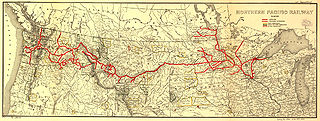
| Description | Map showing the en:Northern Pacific Railway route circa 1900. |
| Date | 29 November 2005 (original upload date) |
| Source |
Transferred from en.wikipedia to Commons by Ian13 using CommonsHelper. Higher resolution JPEG2000 file obtained from [1] and converted to JPEG. |
| Author |
The original uploader was Slambo at English Wikipedia. Later version(s) were uploaded by Ian13 at en.wikipedia. Map created by L.L. Poates Engr'g Co., New York, 1900. Image from the Library of Congress map collection, call number G4126.P3 1900 .L55 RR 502. From Fourth Annual Report of the Northern Pacific Railway company, for the Fiscal Year ending June 30, 1900. Signed in ms: "W. Lowery." Reference: LC Railroad maps, 502. Scale not given. |
| Permission (Reusing this file) |
"The Library of Congress ... is not aware of any U.S. copyright protection (see Title 17 of the United States Code) or any other restrictions in the Map Collection materials." (Source retrieved 2005-11-29) |
| Other versions |
Derivative works of this file:
|
Licensing
[edit]
This media file is in the public domain in the United States. This applies to U.S. works where the copyright has expired, often because its first publication occurred prior to January 1, 1929, and if not then due to lack of notice or renewal. See this page for further explanation.
|
 | |
 |
Original upload log
[edit]
The original description page was here. All following user names refer to en.wikipedia.
- 2008-07-15 21:38 Ian13 8850×3358×8 (9327163 bytes) '
- 2005-11-29 12:21 Slambo 552×208×8 (46806 bytes) Map showing the [[Northern Pacific Railroad]] route circa 1900. Map created by L.L. Poates Engr'g Co., New York, 1900. Image from the Library of Congress map collection, call number G4126.P3 1900 .L55 RR 502. [http://memory.loc.gov/cgi-bin/ammemrr.pl?ti
Original edit log
[edit]
- (cur) (last) 22:43, 15 July 2008 Ian13 (Talk | contribs | block) (1,127 bytes) (tidy + commons tag) (rollback | undo)
- (cur) (last) 22:38, 15 July 2008 Ian13 (Talk | contribs | block) (uploaded a new version of "Image:Northern Pacific Railroad map circa 1900.jpg") (undo)
- (cur) (last) 22:31, 15 July 2008 Ian13 (Talk | contribs | block) m (1,115 bytes) (→Summary: update) (undo)
- (cur) (last) 08:38, 21 June 2006 Lordkinbote (Talk | contribs | block) m (add cat) (undo)
- (cur) (last) 13:21, 29 November 2005 Slambo (Talk | contribs | block) (Map showing the Northern Pacific Railroad route circa 1900. Map created by L.L. Poates Engr'g Co., New York, 1900. Image from the Library of Congress map collection, call number G4126.P3 1900 .L55 RR 502. [http://memory.loc.gov/cgi-bin/ammemrr.pl?ti)
File history
Click on a date/time to view the file as it appeared at that time.
| Date/Time | Thumbnail | Dimensions | User | Comment | |
|---|---|---|---|---|---|
| current | 22:03, 15 July 2008 | 8,850 × 3,358 (8.9 MB) | Ian13 (talk | contribs) | {{Information |Description={{en|Map showing the en:Northern Pacific Railroad route circa 1900. Map created by L.L. Poates Engr'g Co., New York, 1900. Image from the Library of Congress map collection, call number G4126.P3 1900 .L55 RR 502. From Four |
You cannot overwrite this file.
File usage on Commons
The following 6 pages use this file:
- File:Northern Pacific Railroad map circa 1900 Assiniboia.png
- File:Northern Pacific Railroad map circa 1900 Black Hills.png
- File:Northern Pacific Railroad map circa 1900 Schleisingerville.png
- File:Northern Pacific Railway map circa 1900 Cheyenne River Indian Reservation.png
- File:Northern Pacific Railway map circa 1900 Western Washington.jpg
- Category:Northern Pacific Railway
File usage on other wikis
The following other wikis use this file:
- Usage on de.wikipedia.org
- Usage on en.wikipedia.org
- Usage on fr.wikipedia.org
- Usage on it.wikipedia.org
- Usage on ja.wikipedia.org
- Usage on ko.wikipedia.org
- Usage on no.wikipedia.org
- Usage on www.wikidata.org