File:Nuclear power plants map France-fr.png
Jump to navigation
Jump to search

Size of this preview: 600 × 600 pixels. Other resolutions: 240 × 240 pixels | 480 × 480 pixels | 768 × 768 pixels | 1,100 × 1,100 pixels.
Original file (1,100 × 1,100 pixels, file size: 154 KB, MIME type: image/png)
Captions
Captions
Add a one-line explanation of what this file represents

|
File:Nuclear power plants map France-fr.svg is a vector version of this file. It should be used in place of this PNG file when not inferior.
File:Nuclear power plants map France-fr.png → File:Nuclear power plants map France-fr.svg
For more information, see Help:SVG. |
 |
Summary[edit]
| Description |
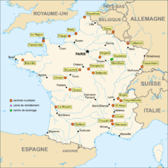
English: Map in French of the French nuclear power plants.
Français : Carte en français des centrales nucléaires, usines de retraitement et centres de stockage en France. |
||
| Date | |||
| Source | Background map : Image:France_blank.svg (modified) made by myself under cc-by-sa | ||
| Author | Eric Gaba (Sting - fr:Sting) | ||
| Permission (Reusing this file) |
|
||
| Other versions |
|


Licensing[edit]
I, the copyright holder of this work, hereby publish it under the following license:
This file is licensed under the Creative Commons Attribution-Share Alike 2.5 Generic license.
- You are free:
- to share – to copy, distribute and transmit the work
- to remix – to adapt the work
- Under the following conditions:
- attribution – You must give appropriate credit, provide a link to the license, and indicate if changes were made. You may do so in any reasonable manner, but not in any way that suggests the licensor endorses you or your use.
- share alike – If you remix, transform, or build upon the material, you must distribute your contributions under the same or compatible license as the original.
File history
Click on a date/time to view the file as it appeared at that time.
| Date/Time | Thumbnail | Dimensions | User | Comment | |
|---|---|---|---|---|---|
| current | 20:19, 7 November 2006 | | 1,100 × 1,100 (154 KB) | Sting (talk | contribs) | {{Information |Description=Map of the French nuclear power plants (in French) |Source=Background map : Image:France_blank.svg (modified) made by myself under cc-by-sa |Date=November 2006 |Author=Eric Gaba (Sting) |Permission=Creative C |
You cannot overwrite this file.
File usage on Commons
The following page uses this file: