File:Oaxaca indigenous people.svg
Jump to navigation
Jump to search

Size of this PNG preview of this SVG file: 800 × 491 pixels. Other resolutions: 320 × 196 pixels | 640 × 393 pixels | 1,024 × 628 pixels | 1,280 × 785 pixels | 2,560 × 1,571 pixels | 849 × 521 pixels.
Original file (SVG file, nominally 849 × 521 pixels, file size: 259 KB)
Captions
Captions
Add a one-line explanation of what this file represents
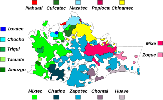
| Description | Primary locations of indigenous people of Oaxaca |
| Date | (UTC) |
| Source | |
| Author |
|
| Other versions | Derivative works of this file: Mixteco y idiomas circundantes.svg |
| This is a retouched picture, which means that it has been digitally altered from its original version. Modifications: Added areas and labels for the different people. The original can be viewed here: Map of Oaxaca.svg:
|
I, the copyright holder of this work, hereby publish it under the following licenses:
This file is licensed under the Creative Commons Attribution-Share Alike 3.0 Unported license.
- You are free:
- to share – to copy, distribute and transmit the work
- to remix – to adapt the work
- Under the following conditions:
- attribution – You must give appropriate credit, provide a link to the license, and indicate if changes were made. You may do so in any reasonable manner, but not in any way that suggests the licensor endorses you or your use.
- share alike – If you remix, transform, or build upon the material, you must distribute your contributions under the same or compatible license as the original.

|
Permission is granted to copy, distribute and/or modify this document under the terms of the GNU Free Documentation License, Version 1.2 or any later version published by the Free Software Foundation; with no Invariant Sections, no Front-Cover Texts, and no Back-Cover Texts. A copy of the license is included in the section entitled GNU Free Documentation License. |
You may select the license of your choice.
Original upload log[edit]
This image is a derivative work of the following images:
- File:Map_of_Oaxaca.svg licensed with Cc-by-sa-3.0, GFDL
- 2008-02-16T19:31:19Z El bart089 602x401 (158277 Bytes) {{Information |Description=Municipalities of Oaxaca |Source=self-made |Date=February 16, 2008 |Author= [[User:El bart089|El bart089]] |Permission= |other_versions= }} [[Category:Mapsof Oaxaca]]
Uploaded with derivativeFX
File history
Click on a date/time to view the file as it appeared at that time.
| Date/Time | Thumbnail | Dimensions | User | Comment | |
|---|---|---|---|---|---|
| current | 15:11, 21 July 2010 | | 849 × 521 (259 KB) | Aymatth2 (talk | contribs) | Correction to location of Ixcatec |
| 23:39, 20 July 2010 |  | 849 × 521 (259 KB) | Aymatth2 (talk | contribs) | {{Information |Description=Primary locations of indigenous people of Oaxaca |Source=*File:Map_of_Oaxaca.svg |Date=2010-07-20 23:37 (UTC) |Author=*File:Map_of_Oaxaca.svg: El bart089 *derivative work: ~~~ |Permission= |other_ |
You cannot overwrite this file.
File usage on Commons
The following 2 pages use this file:
File usage on other wikis
The following other wikis use this file:
- Usage on ca.wikipedia.org
- Usage on en.wikipedia.org
- Usage on fr.wikipedia.org
- Usage on ru.wikipedia.org