File:Oberschlesien 1921.png
Jump to navigation
Jump to search
No higher resolution available.
Oberschlesien_1921.png (411 × 323 pixels, file size: 13 KB, MIME type: image/png)
Captions
Captions
Add a one-line explanation of what this file represents
Summary[edit]
| Description |
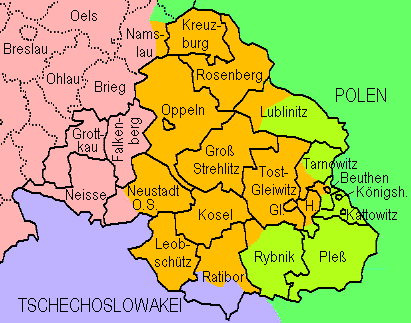
English: Upper Silesia plebiscite 1921: Lined borders = the German border of 1918 and districts of upper Silesia; dotted = Districts of lower Silesia; lilac = Czechoslovakia inclusive territories received from Germany without plebiscite; green = Poland; yellowish green = transferred to Poland after the plebiscite; orange = remaining in Germany after the plebiscite
Deutsch: Volksabstimmung in Oberschlesien 1921: Durchgezogene Grenzen = Reichsgrenze von 1918 und oberschlesische Kreise; gepunktete Grenzen = niederschlesische Kreise. Lila = Tschechoslowakei einschl. von Deutschland erhaltenem Gebiet; grün = Polen; gelbgrün = aufgrund der Abstimmung an Polen gekommenes Gebiet; orange = aufgrund der Abstimmung bei Deutschland gebliebenes Gebiet. Die Markierung der Teilungsgrenze(n) erfolgte anhand Westermanns Monatshefte-Atlas (ca. 1960, "aktuelle" Karte in der damals üblichen retro-Darstellung). Die Darstellung von Kreisen, die nur teilweise zum Abstimmungegebiet gehörten, erfolgte anhand in Berichten genannter Ortsnamen. |
| Date | |
| Source | Own work, redrawn from http://www.gemeindeverzeichnis.de/gem1900/gem1900.htm?gem1900_2.htm , where it is no more available |
| Author | Ulamm |
Licensing[edit]
I, the copyright holder of this work, hereby publish it under the following license:
This file is licensed under the Creative Commons Attribution 3.0 Unported license.
- You are free:
- to share – to copy, distribute and transmit the work
- to remix – to adapt the work
- Under the following conditions:
- attribution – You must give appropriate credit, provide a link to the license, and indicate if changes were made. You may do so in any reasonable manner, but not in any way that suggests the licensor endorses you or your use.
File history
Click on a date/time to view the file as it appeared at that time.
| Date/Time | Thumbnail | Dimensions | User | Comment | |
|---|---|---|---|---|---|
| current | 14:18, 7 August 2009 | | 411 × 323 (13 KB) | Ulamm (talk | contribs) | Division of Kreis Lublinitz |
| 22:16, 12 September 2008 |  | 411 × 323 (13 KB) | Ulamm (talk | contribs) | {{Information |Description= |Source= |Date= |Author= |Permission= |other_versions= }} | |
| 20:39, 12 September 2008 |  | 411 × 330 (13 KB) | Ulamm (talk | contribs) | {{Information |Description={{en|1=Upper Silesia plebiscite 1921: Lined borders = the German border of 1918 and districts of upper Silesia; dotted = Districts of lower Silesia; lilac = Czechoslovakia inclusive territories received from Germany without pleb |
You cannot overwrite this file.
File usage on Commons
The following page uses this file:
File usage on other wikis
The following other wikis use this file:
- Usage on ar.wikipedia.org
- Usage on cs.wikipedia.org
- Usage on de.wikipedia.org
- Usage on el.wikipedia.org
- Usage on en.wikipedia.org
- Usage on fi.wikipedia.org
- Usage on fr.wikipedia.org
- Usage on hu.wikipedia.org
- Usage on id.wikipedia.org
- Usage on incubator.wikimedia.org
- Usage on it.wikipedia.org
- Usage on nl.wikipedia.org
- Usage on pl.wikipedia.org
- Usage on ru.wikipedia.org
- Usage on th.wikipedia.org
- Usage on tr.wikipedia.org
- Usage on zh.wikipedia.org