File:Operation Haddock 1940 map1.png
Jump to navigation
Jump to search
No higher resolution available.
Operation_Haddock_1940_map1.png (624 × 600 pixels, file size: 126 KB, MIME type: image/png)
Captions
Captions
Add a one-line explanation of what this file represents
Summary[edit]
| Description |
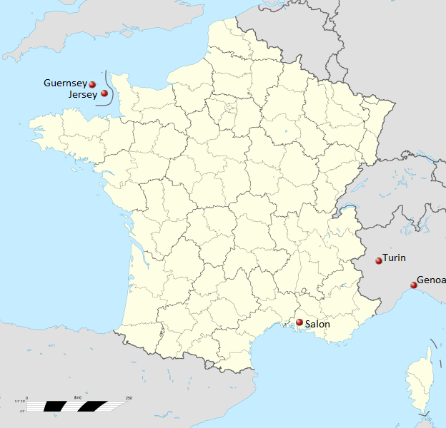
English: Operation Haddock - June 1940: map showing the location of RAF bases in the Channel Islands and at Salon, and the target cities of Turin and Genoa |
| Date | |
| Source | File:France location map-Regions and departements.svg |
| Author | Eric Gaba (Sting - fr:Sting) |
Licensing[edit]
This file is licensed under the Creative Commons Attribution-Share Alike 3.0 Unported license.
- You are free:
- to share – to copy, distribute and transmit the work
- to remix – to adapt the work
- Under the following conditions:
- attribution – You must give appropriate credit, provide a link to the license, and indicate if changes were made. You may do so in any reasonable manner, but not in any way that suggests the licensor endorses you or your use.
- share alike – If you remix, transform, or build upon the material, you must distribute your contributions under the same or compatible license as the original.
File history
Click on a date/time to view the file as it appeared at that time.
| Date/Time | Thumbnail | Dimensions | User | Comment | |
|---|---|---|---|---|---|
| current | 19:27, 11 October 2012 | | 624 × 600 (126 KB) | Alansplodge (talk | contribs) | User created page with UploadWizard |
You cannot overwrite this file.
File usage on Commons
There are no pages that use this file.
File usage on other wikis
The following other wikis use this file:
- Usage on en.wikipedia.org
- Usage on www.wikidata.org