File:Oradour-sur-Glane massacre.jpg
Jump to navigation
Jump to search
Size of this preview: 800 × 538 pixels. Other resolutions: 320 × 215 pixels | 640 × 431 pixels | 1,100 × 740 pixels.
Original file (1,100 × 740 pixels, file size: 384 KB, MIME type: image/jpeg)
Captions
Captions
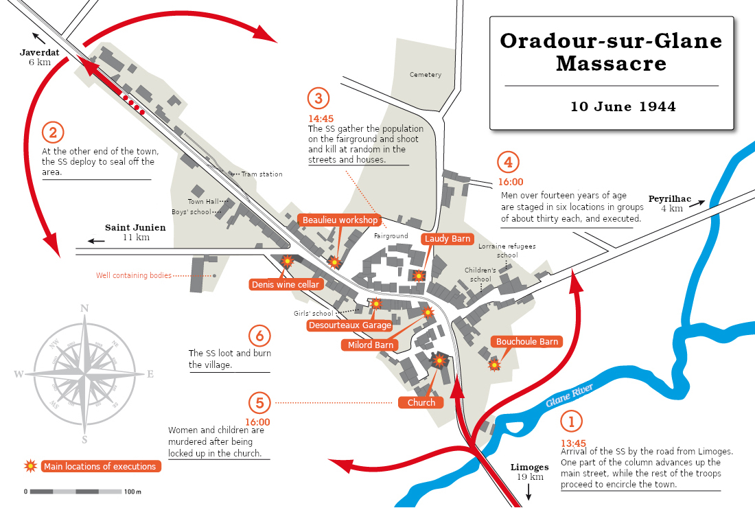
Map of Oradour-sur-Glane massacre on 10 June 1944
Summary
[edit]
Licensing
[edit]
I, the copyright holder of this work, hereby publish it under the following license:
This file is licensed under the Creative Commons Attribution-Share Alike 4.0 International license.
- You are free:
- to share – to copy, distribute and transmit the work
- to remix – to adapt the work
- Under the following conditions:
- attribution – You must give appropriate credit, provide a link to the license, and indicate if changes were made. You may do so in any reasonable manner, but not in any way that suggests the licensor endorses you or your use.
- share alike – If you remix, transform, or build upon the material, you must distribute your contributions under the same or compatible license as the original.
File history
Click on a date/time to view the file as it appeared at that time.
| Date/Time | Thumbnail | Dimensions | User | Comment | |
|---|---|---|---|---|---|
| current | 15:42, 1 July 2021 | | 1,100 × 740 (384 KB) | DutchTreat (talk | contribs) | Changed from "route" -> "road" in box #1 |
| 10:46, 1 July 2021 |  | 1,100 × 740 (382 KB) | DutchTreat (talk | contribs) | Label updates: river name, compass headings "O" -> "W" and wording in caption #1 | |
| 11:44, 30 June 2021 |  | 1,100 × 740 (381 KB) | DutchTreat (talk | contribs) | Uploaded own work with UploadWizard |
You cannot overwrite this file.
File usage on Commons
The following 3 pages use this file:
File usage on other wikis
The following other wikis use this file:
- Usage on en.wikipedia.org
- Usage on fy.wikipedia.org