File:Orders of knighthood Iberia.svg
Jump to navigation
Jump to search

Size of this PNG preview of this SVG file: 772 × 600 pixels. Other resolutions: 309 × 240 pixels | 618 × 480 pixels | 989 × 768 pixels | 1,280 × 995 pixels | 2,560 × 1,989 pixels | 1,749 × 1,359 pixels.
Original file (SVG file, nominally 1,749 × 1,359 pixels, file size: 1.5 MB)
Captions
Captions
Add a one-line explanation of what this file represents
Summary[edit]
| Description |
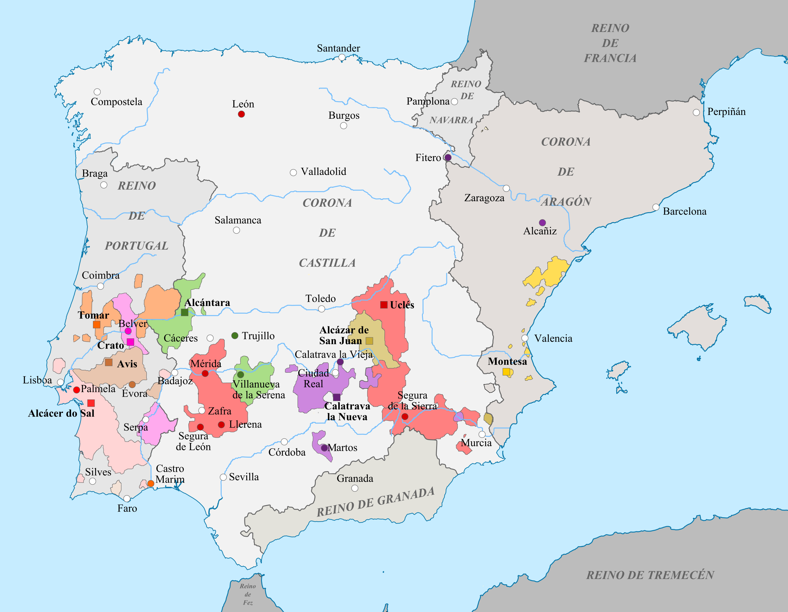
English: Territories of the Orders of Knighthood in the Iberian kingdoms at the end of the 15th century. This map could be incomplete.
Español: Territorios de las órdenes militares de los reinos ibéricos hacia finales del siglo XV. El mapa puede estar incompleto.
Orden de San Juan (Castilla)
Orden de Christo
Orden de Santiago de la Espada
Orden de Avís
Orden de San Juan (Portugal)
|
| Date | |
| Source | Own work |
| Author | Tyk |
Licensing[edit]
I, the copyright holder of this work, hereby publish it under the following licenses:
This file is licensed under the Creative Commons Attribution-Share Alike 3.0 Unported license.
- You are free:
- to share – to copy, distribute and transmit the work
- to remix – to adapt the work
- Under the following conditions:
- attribution – You must give appropriate credit, provide a link to the license, and indicate if changes were made. You may do so in any reasonable manner, but not in any way that suggests the licensor endorses you or your use.
- share alike – If you remix, transform, or build upon the material, you must distribute your contributions under the same or compatible license as the original.

|
Permission is granted to copy, distribute and/or modify this document under the terms of the GNU Free Documentation License, Version 1.2 or any later version published by the Free Software Foundation; with no Invariant Sections, no Front-Cover Texts, and no Back-Cover Texts. A copy of the license is included in the section entitled GNU Free Documentation License. |
You may select the license of your choice.
File history
Click on a date/time to view the file as it appeared at that time.
| Date/Time | Thumbnail | Dimensions | User | Comment | |
|---|---|---|---|---|---|
| current | 13:36, 27 April 2019 | | 1,749 × 1,359 (1.5 MB) | Tyk (talk | contribs) | Improving drawing lines |
| 08:30, 13 May 2011 |  | 1,749 × 1,359 (1.42 MB) | Tyk (talk | contribs) | {{Information |Description ={{en|1=Territories of the Orders of Knighthood in the Iberian kingdoms at the end of the 15th century. This map could be incomplete.}} {{es|1=Territorios de las órdenes militares de los reinos ibéricos hacia finales del si |
You cannot overwrite this file.
File usage on Commons
There are no pages that use this file.
File usage on other wikis
The following other wikis use this file:
- Usage on ar.wikipedia.org
- Usage on arz.wikipedia.org
- Usage on cs.wikipedia.org
- Usage on en.wikipedia.org
- Usage on es.wikipedia.org
- Usage on es.wikibooks.org
- Usage on fr.wikipedia.org
- Usage on pt.wikipedia.org
- Usage on ru.wikipedia.org