File:Osiedla dzielnicy Białołęka (Warszawa).png
Jump to navigation
Jump to search

Size of this preview: 800 × 566 pixels. Other resolutions: 320 × 226 pixels | 640 × 453 pixels | 1,024 × 724 pixels | 1,280 × 905 pixels | 2,560 × 1,810 pixels | 4,961 × 3,508 pixels.
Original file (4,961 × 3,508 pixels, file size: 1.71 MB, MIME type: image/png)
Captions
Captions
Add a one-line explanation of what this file represents
Summary[edit]
.png&action=edit§ion=1)
| Description |
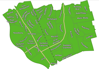
Polski: Osiedla znajdujące się w dzielnicy Białołęka m. st. Warszawy. Zawarte zostały zarówno osiedla zawarte w Państwowym Rejestrze Nazw Geograficznych, jak i nazwy pozostałe (Kalenica, Lejanów, Lewandów, Łapigrosz, Mańki-Wojdy). Lokalizację nazw oparto na PRNG oraz na Mapie Szczegółowej Polski 1:25 000 (1929-1939), granice osiedli określono na podstawie lokalizacji nazw oraz historycznych i aktualnych zasięgów typów zagospodarowania (np. zabudowy), naturalnych i antropogenicznych barier - ulic, linii kolejowych, cieków wodnych. Na mapie poza granicami osiedli zaznaczono główne ulice (Modlińska, Płochocińska, Trasa Mostu Północnego) oraz linię kolejową nr 9 dla orientacji. W razie potrzeby mogę wysłać pliki .shp z granicami poszczególnych osiedli.
English: Subdistricts of Białołęka district of Warsaw. Both the subdistricts included in the National Register of Geographical Names and other (Kalenica, Lejanów, Lewandów, Łapigrosz, Mańki-Wojdy) were included. Location of the names was based on PRNG (PRoGN) and the Detailed Map of Poland 1:25,000 (1929-1939). Boundaries of the subdistricts were determined on the basis of the location of the names on maps and the historical and current ranges of different types of development, natural and anthropogenic barriers - streets, railway lines, watercourses. The main streets are also marked on the map (Modlińska, Płochocińska, Trasa Mostu Północnego), as well as railway line no. 9 for orientation. |
| Date | |
| Source | Own work |
| Author | Jakub Kaczorowski (Kubek15) |
| Other versions | File:Osiedla Białołęki.svg - wersja z 2013 roku z niedokładnymi granicami i lokalizacjami osiedli / 2013 imperfect version |
Licensing[edit]
.png&action=edit§ion=2)
I, the copyright holder of this work, hereby publish it under the following license:
This file is licensed under the Creative Commons Attribution-Share Alike 4.0 International license.
- You are free:
- to share – to copy, distribute and transmit the work
- to remix – to adapt the work
- Under the following conditions:
- attribution – You must give appropriate credit, provide a link to the license, and indicate if changes were made. You may do so in any reasonable manner, but not in any way that suggests the licensor endorses you or your use.
- share alike – If you remix, transform, or build upon the material, you must distribute your contributions under the same or compatible license as the original.
File history
Click on a date/time to view the file as it appeared at that time.
| Date/Time | Thumbnail | Dimensions | User | Comment | |
|---|---|---|---|---|---|
| current | 22:14, 16 March 2021 | | 4,961 × 3,508 (1.71 MB) | Kubek15 (talk | contribs) | Większa czytelność nazw |
| 21:36, 16 March 2021 |  | 4,400 × 3,246 (1.45 MB) | Kubek15 (talk | contribs) | {{Information |Description={{pl|1=Osiedla znajdujące się w dzielnicy Białołęka m. st. Warszawy. Zawarte zostały zarówno osiedla zawarte w Państwowym Rejestrze Nazw Geograficznych, jak i nazwy pozostałe (Kalenica, Lejanów, Lewandów, Łapigrosz, Mańki-Wojdy). Lokalizację nazw oparto na PRNG oraz na Mapie Szczegółowej Polski 1:25 000 (1929-1939), granice osiedli określono na podstawie lokalizacji nazw oraz historycznych i aktualnych zasięgów typów zagospodarow... |
You cannot overwrite this file.
File usage on Commons
The following 2 pages use this file:
File usage on other wikis
The following other wikis use this file:
- Usage on pl.wikipedia.org
.png&oldid=769944976)