File:Ottomans 1875.png
Jump to navigation
Jump to search
Size of this preview: 540 × 599 pixels. Other resolutions: 216 × 240 pixels | 432 × 480 pixels | 692 × 768 pixels | 923 × 1,024 pixels | 1,845 × 2,048 pixels | 5,384 × 5,976 pixels.
Original file (5,384 × 5,976 pixels, file size: 6.47 MB, MIME type: image/png)
Captions
Captions
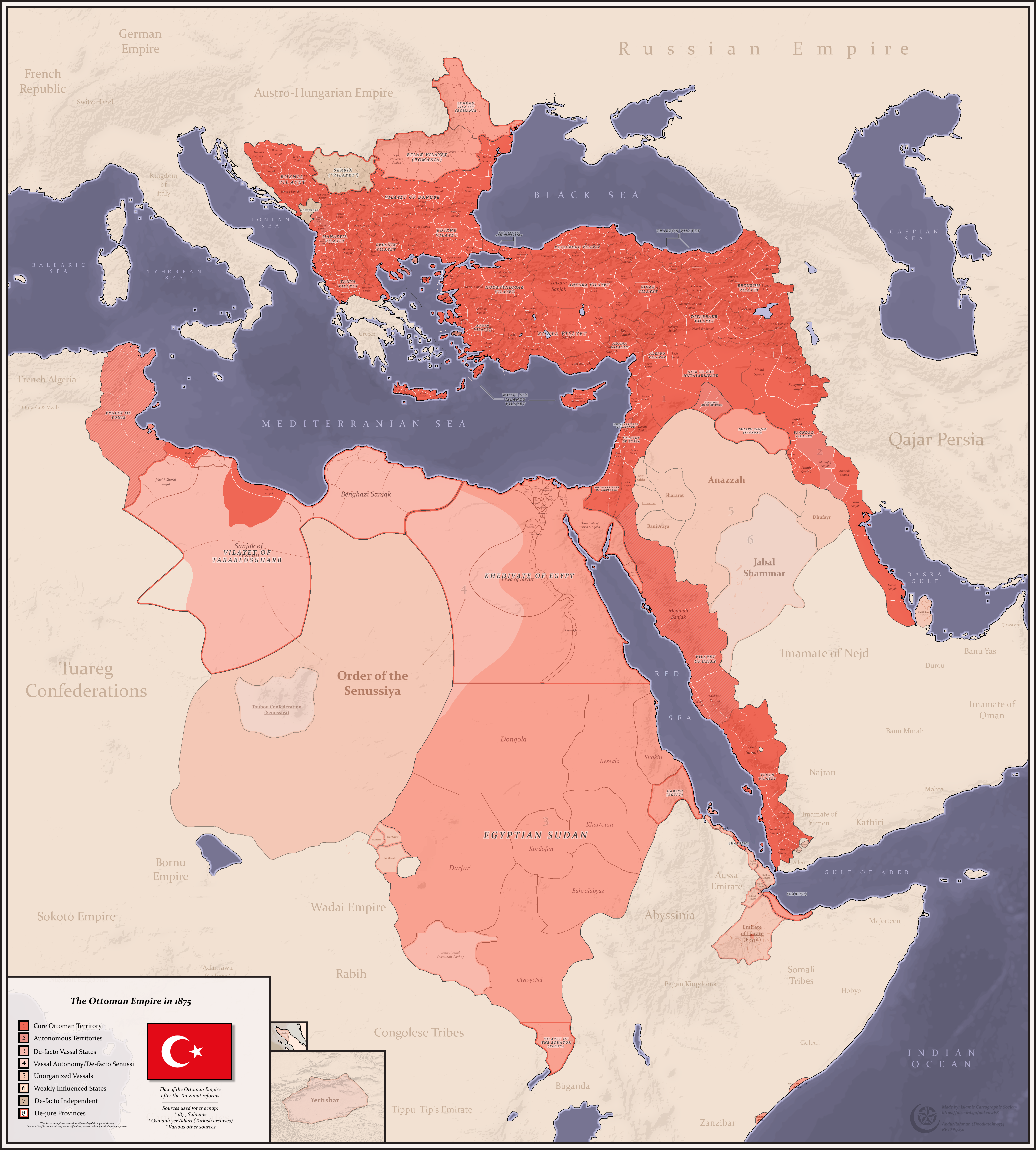
Detailed map of the Ottoman Empire in the gregorian year 1875

|
This map image could be re-created using vector graphics as an SVG file. This has several advantages; see Commons:Media for cleanup for more information. If an SVG form of this image is available, please upload it and afterwards replace this template with
{{vector version available|new image name}}.
It is recommended to name the SVG file “Ottomans 1875.svg”—then the template Vector version available (or Vva) does not need the new image name parameter. |
Summary
[edit]
| Description |
English: A Detailed map of the Ottoman Empire, it's divisions and vassals in the gregorian year 1875
Sources: - Salname of 1875 - Osmanli yer Adlari (from turkish archives) - Other sources |
| Date | |
| Source | Own work |
| Author | AbdurRahman AbdulMoneim |
Licensing
[edit]
I, the copyright holder of this work, hereby publish it under the following license:
This file is licensed under the Creative Commons Attribution-Share Alike 4.0 International license.
- You are free:
- to share – to copy, distribute and transmit the work
- to remix – to adapt the work
- Under the following conditions:
- attribution – You must give appropriate credit, provide a link to the license, and indicate if changes were made. You may do so in any reasonable manner, but not in any way that suggests the licensor endorses you or your use.
- share alike – If you remix, transform, or build upon the material, you must distribute your contributions under the same or compatible license as the original.
File history
Click on a date/time to view the file as it appeared at that time.
| Date/Time | Thumbnail | Dimensions | User | Comment | |
|---|---|---|---|---|---|
| current | 08:43, 28 January 2022 | | 5,384 × 5,976 (6.47 MB) | Userd898 (talk | contribs) | better representation of tunisia |
| 08:28, 28 January 2022 |  | 5,384 × 5,976 (6.46 MB) | Userd898 (talk | contribs) | improved the map key | |
| 07:34, 28 January 2022 |  | 5,384 × 5,976 (6.44 MB) | Userd898 (talk | contribs) | danube sanjaks fixed, corfu fixed | |
| 12:08, 27 January 2022 |  | 5,384 × 5,976 (6.44 MB) | Userd898 (talk | contribs) | fixed bulgaria | |
| 12:34, 25 January 2022 |  | 5,384 × 5,976 (6.43 MB) | Userd898 (talk | contribs) | fixed a lot of things | |
| 11:07, 25 January 2022 |  | 5,384 × 5,976 (5.99 MB) | Userd898 (talk | contribs) | lake chad | |
| 10:13, 25 January 2022 |  | 5,384 × 5,976 (5.99 MB) | Userd898 (talk | contribs) | jiza and qatrana added to salat sanjak | |
| 10:01, 25 January 2022 |  | 5,384 × 5,976 (5.99 MB) | Userd898 (talk | contribs) | fixed hejaz | |
| 22:20, 23 January 2022 |  | 5,384 × 5,976 (5.99 MB) | Userd898 (talk | contribs) | some fixes | |
| 21:21, 23 January 2022 |  | 5,384 × 5,976 (5.99 MB) | Userd898 (talk | contribs) | Uploaded own work with UploadWizard |
You cannot overwrite this file.
File usage on Commons
The following page uses this file:
File usage on other wikis
The following other wikis use this file:
- Usage on arz.wikipedia.org
- Usage on en.wikipedia.org
- Usage on es.wikipedia.org
- Usage on ext.wikipedia.org
- Usage on he.wikipedia.org
- Usage on mk.wikipedia.org
- Usage on pt.wikipedia.org
- Usage on ru.wikipedia.org
- Usage on szl.wikipedia.org
- Usage on tr.wikipedia.org
- Usage on vi.wikipedia.org