File:PIA13708westernrimgeo.jpg

Original file (4,023 × 7,854 pixels, file size: 4.23 MB, MIME type: image/jpeg)
Captions
Captions

|
This file was moved to Wikimedia Commons from en.wikipedia using a bot script. All source information is still present. It requires review. Additionally, there may be errors in any or all of the information fields; information on this file should not be considered reliable and the file should not be used until it has been reviewed and any needed corrections have been made. Once the review has been completed, this template should be removed. For details about this file, see below. Check now! |
Summary[edit]
| Description |
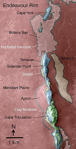
English: This map indicates some of the geological information gained from orbital observations of Endeavour Crater, which has been the long-term destination for NASA's Mars Exploration Rover Opportunity since mid-2008.
Endeavour Crater is about 22 kilometers (14 miles) in diameter. As indicated by the scale bar of one kilometer (0.6 mile), this map covers only a small portion of the crater's western rim. A discontinuous ridge runs north-south, exposing basalt (coded blue) and clay minerals (coded green) believed to be from a time in Martian history before the deposition of sulfates on the portions of the Meridiani Plains region that Opportunity has seen during the rover's first seven years on Mars. The rover team plans to begin Opportunity's exploration of the Endeavour rim near "Cape York," which is about 6.5 kilometers (4 miles) from the rover's location in mid-December 2010. Cape York is nearly surrounded by exposures of hydrated bedrock. From there, the planned exploration route goes south along the rim fragment "Solander Point," to "Cape Tribulation," where clay minerals have been detected. This geological map is based on observations by the Compact Reconnaissance Imaging Spectrometer for Mars (CRISM) on NASA's Mars Reconnaissance Orbiter. |
| Date | |
| Source | https://photojournal.jpl.nasa.gov/catalog/PIA13708 |
| Author | NASA/JPL-Caltech/JHUAPL |
Licensing[edit]
| This file is in the public domain in the United States because it was solely created by NASA. NASA copyright policy states that "NASA material is not protected by copyright unless noted". (See Template:PD-USGov, NASA copyright policy page or JPL Image Use Policy.) | ||
 |
Warnings:
|
Original upload log[edit]
| Date/Time | Dimensions | User | Comment |
|---|---|---|---|
| 2016-10-12 17:10 | 4023×7854× (4431187 bytes) | Fotaun | {{PD-NASA}} http://photojournal.jpl.nasa.gov/jpeg/PIA13708.jpg http://www.jpl.nasa.gov/spaceimages/details.php?id=PIA13708 his map indicates some of the geological information gained from orbital observations of Endeavour Crater, which has been the l... |
File history
Click on a date/time to view the file as it appeared at that time.
| Date/Time | Thumbnail | Dimensions | User | Comment | |
|---|---|---|---|---|---|
| current | 05:25, 19 August 2018 | | 4,023 × 7,854 (4.23 MB) | JCPagc2015 (talk | contribs) | Transferred from en.wikipedia via #commonshelper |
You cannot overwrite this file.
File usage on Commons
There are no pages that use this file.
File usage on other wikis
The following other wikis use this file:
- Usage on en.wikipedia.org
- Usage on es.wikipedia.org