File:Países de Lengua Ibérica.svg

Original file (SVG file, nominally 3,121 × 1,586 pixels, file size: 2.6 MB)
Captions
Captions
Summary[edit]
| Description |
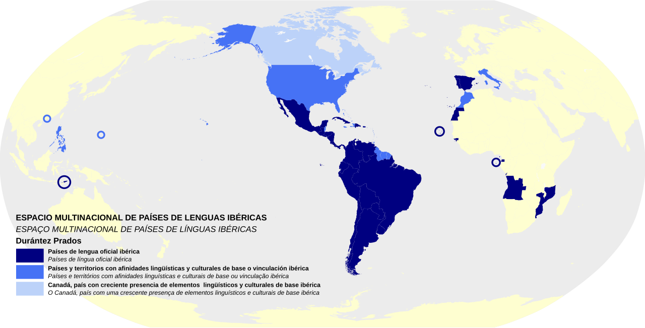
Español: ESPACIO MULTINACIONAL DE PAÍSES DE LENGUAS IBÉRICAS, según Durántez Prados
En azul oscuro, países de lengua oficial ibérica. En azul, países y territorios con afinidades lingüísticas y culturales de base o vinculación ibérica. En azul claro, Canadá, país con creciente presencia de elementos lingüísticosy culturales de base ibérica. Fuente: -TESIS DOCTORAL, UNIVERSIDAD COMPLUTENSE DE MADRID, Paralelismos y convergencias entre la comunidad iberoamericana de naciones y la comunidad de países de lengua portuguesa : ¿existe un espacio multinacional de países de lenguas ibéricas? De Frigdiano Álvaro Durántez Prados. http://eprints.ucm.es/24644/1/T35176.pdf -Cartografía base de Wikimedia Commons, de libre copia y modificación. |
| Date | |
| Source | Own work |
| Author | Nagihuin |
Licensing[edit]
| This file is made available under the Creative Commons CC0 1.0 Universal Public Domain Dedication. | |
| The person who associated a work with this deed has dedicated the work to the public domain by waiving all of their rights to the work worldwide under copyright law, including all related and neighboring rights, to the extent allowed by law. You can copy, modify, distribute and perform the work, even for commercial purposes, all without asking permission.
|
File history
Click on a date/time to view the file as it appeared at that time.
| Date/Time | Thumbnail | Dimensions | User | Comment | |
|---|---|---|---|---|---|
| current | 12:34, 17 November 2018 | | 3,121 × 1,586 (2.6 MB) | Nagihuin (talk | contribs) | Fondo. |
| 16:22, 20 August 2016 |  | 3,121 × 1,586 (2.6 MB) | Nagihuin (talk | contribs) | Incluido Belize e islas Marianas ya que también figuran en el mapa original del Profesor Durántez Prados. Incluida traducción al portugués en la leyenda. | |
| 07:28, 30 March 2016 |  | 3,121 × 1,586 (2.6 MB) | Nagihuin (talk | contribs) | Redibujado bajo el concepto de Espacio Multinacional de Países de Lenguas Ibéricas del profesor Durántez Prados y explicado en su tesis. | |
| 01:05, 17 January 2016 |  | 3,121 × 1,586 (2.6 MB) | Nagihuin (talk | contribs) | Más información. | |
| 15:48, 21 November 2015 |  | 940 × 415 (1.5 MB) | Nagihuin (talk | contribs) | reverted | |
| 15:35, 21 November 2015 |  | 940 × 415 (1.5 MB) | Nagihuin (talk | contribs) | Reverted | |
| 22:06, 5 November 2015 |  | 863 × 443 (6.67 MB) | Nagihuin (talk | contribs) | Mejor calidad, basado en https://commons.wikimedia.org/wiki/File:Blank_Map_World_Secondary_Political_Divisions.svg | |
| 14:48, 17 August 2015 |  | 940 × 415 (1.5 MB) | Nagihuin (talk | contribs) | User created page with UploadWizard |
You cannot overwrite this file.
File usage on Commons
The following page uses this file:
File usage on other wikis
The following other wikis use this file:
- Usage on ast.wikipedia.org
- Usage on es.wikipedia.org
- Usage on pt.wikipedia.org
- Usage on www.wikidata.org