File:Paris Metro line 2 map.svg
Jump to navigation
Jump to search

Size of this PNG preview of this SVG file: 800 × 521 pixels. Other resolutions: 320 × 208 pixels | 640 × 417 pixels | 1,024 × 667 pixels | 1,280 × 834 pixels | 2,560 × 1,667 pixels | 1,371 × 893 pixels.
Original file (SVG file, nominally 1,371 × 893 pixels, file size: 49 KB)
Captions
Captions
Add a one-line explanation of what this file represents
Summary[edit]
| Title |
Paris Metro line 2 map.svg |
|||||||||
| Description |
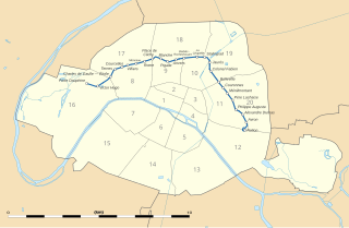
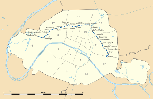
English: Map of the Paris Métro Line 2 with districts, derivated from File:Numbered map of Paris with arrondissements.svg.
Français : Carte de la ligne 2 du métro de Paris with arrondissements, basée sur File:Numbered map of Paris with arrondissements.svg. |
|||||||||
| SVG development | This map was created with Adobe Illustrator. |
|||||||||
| Date | ||||||||||
| Source |
Own work
|
|||||||||
| Creator |
User:Sting / OpenStreetMap / 144p |
|||||||||
| Permission (Reusing this file) |
|
|||||||||
| Geotemporal data | ||||||||||
| Date depicted | ||||||||||
| Map location | Paris 48°51′24″N 2°21′03″E / 48.8567°N 2.3508°E | |||||||||
| Spatial reference system | WGS84 datum | |||||||||
| Scale | 1:124,000 (precision: 31 m) | |||||||||
| Heading |
 |
|||||||||
| Bounding box |
|
|||||||||
| Georeferencing | If inappropriate please set warp_status = skip to hide. | |||||||||
| Other versions |
|
|||||||||

.svg)
Licensing[edit]
Eric Gaba, Wikimedia Commons user Sting, the copyright holder of this work, hereby publishes it under the following license:
This file is licensed under the Creative Commons Attribution-Share Alike 3.0 Unported license.
Attribution: Eric Gaba, Wikimedia Commons user Sting
- You are free:
- to share – to copy, distribute and transmit the work
- to remix – to adapt the work
- Under the following conditions:
- attribution – You must give appropriate credit, provide a link to the license, and indicate if changes were made. You may do so in any reasonable manner, but not in any way that suggests the licensor endorses you or your use.
- share alike – If you remix, transform, or build upon the material, you must distribute your contributions under the same or compatible license as the original.
| This work contains information from OpenStreetMap, which is made available under the Open Database License (ODbL).
The ODbL does not require any particular license for maps produced from ODbL data. Prior to 1 August 2020, map tiles produced by the OpenStreetMap Foundation were licensed under the CC-BY-SA-2.0 license. Maps produced by other people may be subject to other licences. |
File history
Click on a date/time to view the file as it appeared at that time.
| Date/Time | Thumbnail | Dimensions | User | Comment | |
|---|---|---|---|---|---|
| current | 21:41, 30 November 2021 | | 1,371 × 893 (49 KB) | Puck04 (talk | contribs) | fixed SVG code (was "W3C-invalid") + cleanup using text editor |
| 08:56, 14 January 2018 |  | 1,371 × 893 (218 KB) | 144p (talk | contribs) | Reverted to version as of 08:36, 14 January 2018 (UTC) | |
| 08:55, 14 January 2018 |  | 1,371 × 893 (221 KB) | 144p (talk | contribs) | Try bolder line | |
| 08:36, 14 January 2018 |  | 1,371 × 893 (218 KB) | 144p (talk | contribs) | {{Information |Description ={{en|1=Map of the Paris Métro Line 2.}} {{fr|1=Carte de la ligne 2 du métro de Paris.}} |Source ={{Own}} |Author =User:Sting / OpenStre... |
You cannot overwrite this file.
File usage on Commons
The following 9 pages use this file:
- User:Chumwa/OgreBot/Potential transport maps/2018 January 11-20
- User:Chumwa/OgreBot/Public transport information/2018 January 11-20
- User:Chumwa/OgreBot/Public transport information/2021 November 21-30
- User:Chumwa/OgreBot/Transport Maps/2018 January 11-20
- User:Chumwa/OgreBot/Transport Maps/2021 November 21-30
- User:Chumwa/OgreBot/Travel and communication maps/2018 January 11-20
- User:Chumwa/OgreBot/Travel and communication maps/2021 November 21-30
- User:Paris 16/Recent uploads/2021 November 28-30
- File:Paris Metro line 2 map (with land cover).svg