File:Patalpani Waterfall.jpg
Original file (4,028 × 2,412 pixels, file size: 2.98 MB, MIME type: image/jpeg)
Captions
Summary[edit]
This image needs to have its border removed. Where borders are desired they should be added with wikimarkup or code.
NOTE: Engravings, etchings, photogravures, or any image where information would be lost, or the frame is integral part of the original postcard, document etc., DO NOT NEED their borders cropped; a cropped image of this type generally will violate the original artistic intent of the image, which includes the paper surrounding it. Especially images with {{Border is intentional}} should be not overwritten. If it is desirable to have a cropped version for specific uses, this should be uploaded as a separate file, and linked back to the original. This can be requested by using {{Extract image}} instead. If the file is a photo of an artwork in perspective and with context (a physical frame, a place where the work is located etc.), use {{Extract image}} for request for a detailed image or a flat copy. Any text from the border should be included in the image description. If the border contains author and license information, this may also be embedded in the file itself and the tag, {{Metadata from image}}, should be added. If cropping a JPEG, it is generally preferable to use a lossless cropping tool. You can use CropTool on this file, which supports lossless cropping (more info). Other available tools include Cropbot and jpegtran. For more help, see Commons:Media for cleanup.català ∙ čeština ∙ Deutsch ∙ English ∙ español ∙ français ∙ italiano ∙ magyar ∙ 日本語 ∙ മലയാളം ∙ Plattdüütsch ∙ polski ∙ português ∙ sicilianu ∙ македонски ∙ русский ∙ slovenščina ∙ Türkçe ∙ українська ∙ 中文 ∙ 中文(简体) ∙ +/− |
DescriptionPatalpani Waterfall.jpg |
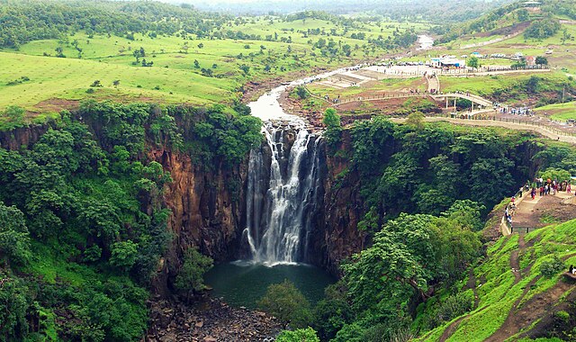
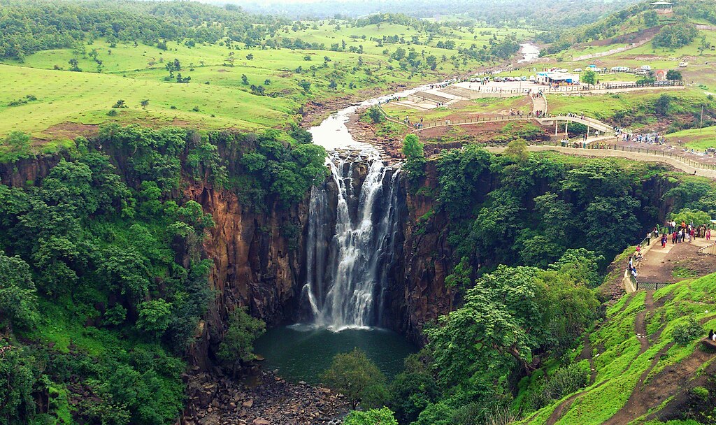
English: PatalPani Waterfall, a magnificent fall situated around 35 KM from Indore, Madhya Pradesh |
Date | |
Source | Own work |
Author | Vivek Shrivastava |
Camera location | 22° 30′ 14.87″ N, 75° 48′ 03.18″ E | View this and other nearby images on: OpenStreetMap | 22.504130; 75.800884 |
---|
Licensing[edit]
- You are free:
- to share – to copy, distribute and transmit the work
- to remix – to adapt the work
- Under the following conditions:
- attribution – You must give appropriate credit, provide a link to the license, and indicate if changes were made. You may do so in any reasonable manner, but not in any way that suggests the licensor endorses you or your use.
- share alike – If you remix, transform, or build upon the material, you must distribute your contributions under the same or compatible license as the original.
File history
Click on a date/time to view the file as it appeared at that time.
Date/Time | Thumbnail | Dimensions | User | Comment | |
---|---|---|---|---|---|
current | 07:15, 15 September 2013 | 4,028 × 2,412 (2.98 MB) | Lucky vivs (talk | contribs) | User created page with UploadWizard |
You cannot overwrite this file.
File usage on Commons
There are no pages that use this file.
File usage on other wikis
The following other wikis use this file:
- Usage on bcl.wikipedia.org
- Usage on bn.wikipedia.org
- Usage on en.wikipedia.org
- Usage on gu.wikipedia.org
- Usage on hi.wikipedia.org
- Usage on ta.wikipedia.org
- Usage on ur.wikipedia.org
Metadata
This file contains additional information such as Exif metadata which may have been added by the digital camera, scanner, or software program used to create or digitize it. If the file has been modified from its original state, some details such as the timestamp may not fully reflect those of the original file. The timestamp is only as accurate as the clock in the camera, and it may be completely wrong.
Camera manufacturer | Sony Ericsson |
---|---|
Camera model | LT26ii |
Author | Picasa |
Exposure time | 1/320 sec (0.003125) |
F-number | f/2.4 |
ISO speed rating | 50 |
Date and time of data generation | 11:46, 21 July 2013 |
Lens focal length | 4.48 mm |
Latitude | 22° 30′ 14.87″ N |
Longitude | 75° 48′ 3.18″ E |
Altitude | 463 meters above sea level |
Horizontal resolution | 72 dpi |
Vertical resolution | 72 dpi |
Software used | 6.2.B.0.200_58_f100 |
File change date and time | 11:45, 15 September 2013 |
Y and C positioning | Centered |
Exif version | 2.2 |
Date and time of digitizing | 11:46, 21 July 2013 |
Meaning of each component |
|
APEX shutter speed | 8.32 |
APEX exposure bias | 0 |
Metering mode | Center weighted average |
Light source | Unknown |
Flash | Flash did not fire, compulsory flash suppression |
Supported Flashpix version | 1 |
Color space | sRGB |
Custom image processing | Normal process |
Exposure mode | Auto exposure |
White balance | Auto white balance |
Digital zoom ratio | 1 |
Scene capture type | Landscape |
Subject distance range | Unknown |
Unique image ID | 5d997a9ae8514c8c0fc4990093cb134f |
GPS time (atomic clock) | 06:15 |
Receiver status | Measurement in progress |
Geodetic survey data used | WGS-84 |
GPS date | 21 July 2013 |
GPS tag version | 2.2.0.0 |
IIM version | 4 |