File:Persepolis complex map deutsch.png
Jump to navigation
Jump to search

Size of this preview: 800 × 570 pixels. Other resolutions: 320 × 228 pixels | 640 × 456 pixels | 1,024 × 730 pixels | 1,078 × 768 pixels.
Original file (1,078 × 768 pixels, file size: 449 KB, MIME type: image/png)
Captions
Captions
Add a one-line explanation of what this file represents

|
This architecture image could be re-created using vector graphics as an SVG file. This has several advantages; see Commons:Media for cleanup for more information. If an SVG form of this image is available, please upload it and afterwards replace this template with
{{vector version available|new image name}}.
It is recommended to name the SVG file “Persepolis complex map deutsch.svg”—then the template Vector version available (or Vva) does not need the new image name parameter. |
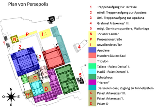
| Description | Map of Persepolis royal palaces complex. Made by Pentocelo as synthesis of original shemes and datas issued from several works by Ertzfeld, Dutz, Lendering, and Stierlin |
| Date | (UTC) |
| Source | |
| Author |
|
| This is a retouched picture, which means that it has been digitally altered from its original version. Modifications: changed to German language. The original can be viewed here: Persepolis complex map french.jpg:
|
This file is licensed under the Creative Commons Attribution-Share Alike 3.0 Unported license.
- You are free:
- to share – to copy, distribute and transmit the work
- to remix – to adapt the work
- Under the following conditions:
- attribution – You must give appropriate credit, provide a link to the license, and indicate if changes were made. You may do so in any reasonable manner, but not in any way that suggests the licensor endorses you or your use.
- share alike – If you remix, transform, or build upon the material, you must distribute your contributions under the same or compatible license as the original.
Original upload log[edit]
This image is a derivative work of the following images:
- Image:Persepolis_complex_map_french.jpg licensed with PD-self
- 2007-01-13T06:42:35Z Pentocelo 1024x768 (144574 Bytes) Map of Persepolis royal palaces complex. Made by Pentocelo as synthesis of original shemes and datas issued from several works by Ertzfeld, Dutz, Lendering, and Stierlin [[Category:Persépolis]]
Uploaded with derivativeFX
File history
Click on a date/time to view the file as it appeared at that time.
| Date/Time | Thumbnail | Dimensions | User | Comment | |
|---|---|---|---|---|---|
| current | 14:08, 2 November 2008 | | 1,078 × 768 (449 KB) | Horstovich (talk | contribs) | {{Information |Description=Map of Persepolis royal palaces complex. Made by Pentocelo as synthesis of original shemes and datas issued from several works by Ertzfeld, Dutz, Lendering, and Stierlin |Source=*Image:Persepolis_complex_map_french.jpg |Da |
You cannot overwrite this file.
File usage on Commons
There are no pages that use this file.
File usage on other wikis
The following other wikis use this file:
- Usage on de.wikipedia.org
- Usage on de.wikivoyage.org
- Usage on ja.wikipedia.org