File:Perth Town Walls Plan.png
Jump to navigation
Jump to search

Size of this preview: 571 × 600 pixels. Other resolutions: 228 × 240 pixels | 457 × 480 pixels | 731 × 768 pixels | 975 × 1,024 pixels | 2,108 × 2,215 pixels.
Original file (2,108 × 2,215 pixels, file size: 1.19 MB, MIME type: image/png)
Captions
Captions
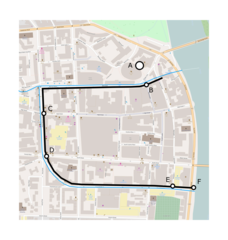
A plan of the former town walls around Perth, Scotland
Summary[edit]
| Description |
English: An indicative plan showing the medieval walls around Perth, Scotland. The walls followed present day Murray Street, South Methven Street, Canal Crescent and Canal Street. No part of the wall is still standing. The blue line marks the mill lade/ditches. The positions of gates (ports) and towers are marked including:
(A) the site of Perth Castle; (B) Red Brig Port; (C) Turret Brig Port; (D) South Street Port; (E) Spey Tower; (F) Monk's Tower. |
| Date | |
| Source | Own work |
| Author | What Are The Civilian Applications? |
| Other versions |

Licensing[edit]
I, the copyright holder of this work, hereby publish it under the following license:
This file is licensed under the Creative Commons Attribution-Share Alike 4.0 International license.
- You are free:
- to share – to copy, distribute and transmit the work
- to remix – to adapt the work
- Under the following conditions:
- attribution – You must give appropriate credit, provide a link to the license, and indicate if changes were made. You may do so in any reasonable manner, but not in any way that suggests the licensor endorses you or your use.
- share alike – If you remix, transform, or build upon the material, you must distribute your contributions under the same or compatible license as the original.
File history
Click on a date/time to view the file as it appeared at that time.
| Date/Time | Thumbnail | Dimensions | User | Comment | |
|---|---|---|---|---|---|
| current | 11:06, 12 February 2019 | | 2,108 × 2,215 (1.19 MB) | What Are The Civilian Applications? (talk | contribs) | User created page with UploadWizard |
You cannot overwrite this file.
File usage on Commons
The following page uses this file:
File usage on other wikis
The following other wikis use this file:
- Usage on en.wikipedia.org