File:Peters projection, date line in Bering strait.svg
Jump to navigation
Jump to search

Size of this PNG preview of this SVG file: 800 × 545 pixels. Other resolutions: 320 × 218 pixels | 640 × 436 pixels | 1,024 × 697 pixels | 1,280 × 871 pixels | 2,560 × 1,743 pixels | 1,613 × 1,098 pixels.
Original file (SVG file, nominally 1,613 × 1,098 pixels, file size: 808 KB)
Captions
Captions
Add a one-line explanation of what this file represents
Summary[edit]
| Description |
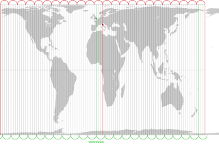
English: The Peters projection with corrected date line in the Bering strait, 168°45' West of Greenwich, proposed by Arno Peters. On his world map the easternmost part of Russia is not displayed left of Alaska, as it is usually done. Instead, it is on the right with the rest of Russia. The antipode of Peters' corrected date line is the meridian, 11° 15' East of Greenwich, traversing the city center of Florence in Italy.
The drawn out 96 meridians mark quarters of the hour. Green: Longitude of Greenwich and the old date line. Red: Longitude of Florence and Peters date line.Deutsch: Die Peters-Projektion mit korrigierter Datumsgrenze in der Beringstraße, 168°45' westlich von Greenwich. Diese wurde von Arno Peters vorgeschlagen, damit die Ostspitze Russlands auf der Weltkarte nicht wie sonst üblich abgeschnitten und links von Alaska dargestellt wird.
Die Antipode zu Peters' korrigierter Datumsgrenze ist der Meridian 11° 15' östlich von Greenwich, der durch das Stadtzentrum von Florenz in Italien verläuft. Die ausgezogenen 96 Meridiane markieren Viertelstunden. Grün: Länge von Greenwich und alte Datumsgrenze. Rot. Länge von Florenz und korrigierte Datumsgrenze in der Beringstraße. |
| Date | |
| Source | Own work by uploader. On this Peters map you can see the corrected date line |
| Author | Watchduck |
| Other versions | Derivative works of this file: Peters projection, blank.svg |
Licensing[edit]
| I, the copyright holder of this work, release this work into the public domain. This applies worldwide. In some countries this may not be legally possible; if so: I grant anyone the right to use this work for any purpose, without any conditions, unless such conditions are required by law. |
File history
Click on a date/time to view the file as it appeared at that time.
| Date/Time | Thumbnail | Dimensions | User | Comment | |
|---|---|---|---|---|---|
| current | 22:27, 13 March 2009 | | 1,613 × 1,098 (808 KB) | Watchduck (talk | contribs) | |
| 17:11, 13 March 2009 |  | 1,613 × 1,098 (1.85 MB) | Watchduck (talk | contribs) | ||
| 15:54, 13 March 2009 |  | 1,613 × 1,190 (1.85 MB) | Watchduck (talk | contribs) | {{Information |Description={{en|1=The Peters projection with corrected date line in the Bering strait, 168°45' West of Greenwich, proposed by Arno Peters not to |
You cannot overwrite this file.
File usage on Commons
The following page uses this file:
File usage on other wikis
The following other wikis use this file:
- Usage on ca.wikipedia.org
- Usage on en.wikipedia.org
- Usage on eo.wikipedia.org
- Usage on es.wikipedia.org
- Usage on fi.wikipedia.org
- Usage on fr.wikipedia.org
- Usage on he.wikipedia.org
- Usage on id.wikipedia.org
- Usage on it.wikipedia.org
- Usage on la.wikipedia.org
- Usage on nds-nl.wikipedia.org
- Usage on oc.wikipedia.org
- Usage on pt.wikipedia.org
- Usage on ru.wikipedia.org
- Usage on sq.wikipedia.org
- Usage on tr.wikipedia.org
- Usage on zh.wikipedia.org