File:PikiWiki Israel 3322 Mitzpeh Hilla wing bird.JPG
Jump to navigation
Jump to search

Size of this preview: 800 × 541 pixels. Other resolutions: 320 × 216 pixels | 640 × 433 pixels | 822 × 556 pixels.
Original file (822 × 556 pixels, file size: 123 KB, MIME type: image/jpeg)
Captions
Captions
Add a one-line explanation of what this file represents
| Description |
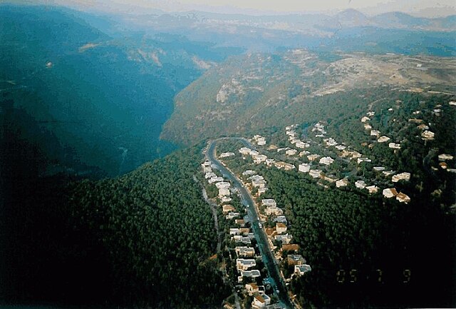
English: Mitzpe Hila located in the Western Galilee on the western sloping of the Ziv hills, altitude of 510 m above sea level, 5 km west to Ma\'alot-Tarshiha. The access road passes through the Christian village Mailya mrege to Nahriya-Ma\'alot road. , Note: 2357 עברית: מצפה הילה נמצא בגליל המערבי, ממוקם על מדרונו המערבי של הר-זיו בגובה של 510 מ' מעל פני הים, 2 ק"מ מערבית לכפר הנוצרי מעיליא וכ-5 ק"מ מערבית למעלות-תרשיחא. דרך הגישה עוברת דרך מעיליא ומתחברת לכביש נהריה-מעלות.
התמונה צולמה לכיוון מזרח כשמשמאל, נחל כזיב, OriginalName: מצפה הילה ממעוף הציפור , Location: מצפה הילה Mitzpe Hilla |
| Date | |
| Source | Mitzpeh Hilla Archive via the PikiWiki - Israel free image collection project |
| Author | עמי כתבן Ami Katvan |
| Permission (Reusing this file) |
This file is licensed under the Creative Commons Attribution 2.5 Generic license. Attribution: ארכיון מצפה הילה Mitzpeh Hilla Archive
|

|
This file has been submitted through the Israeli Pikiwiki project and uploaded here automatically.
The project is cooperation between the Israel Internet Association and Wikimedia Israel in an effort to promote the concept of free content on the Web, by creating an image collection of digital-format, good quality photographs, documenting events relating to the history of Israel, or depicting places of distinction in Israel and the Middle East. The Pikiwiki Project is managed from 2021 by the "Heritage Stones" group.
Please consider notifying the project before renaming or deleting this file. Further information about the project can be found on the commons-l mailing list.
|
File history
Click on a date/time to view the file as it appeared at that time.
| Date/Time | Thumbnail | Dimensions | User | Comment | |
|---|---|---|---|---|---|
| current | 15:43, 2 November 2023 | | 822 × 556 (123 KB) | Enaecard (talk | contribs) | -upscaled, normal resolution |
| 00:07, 1 July 2009 |  | 1,643 × 1,112 (217 KB) | Pikiwikisrael (talk | contribs) | {{Information |Description={{en|Mitzpe Hila located in the Western Galilee on the western sloping of the Ziv hills, altitude of 510 m above sea level, 5 km west to Ma\'alot-Tarshiha. The access road passes through the Christian village Mailya mrege to Nah |
You cannot overwrite this file.
File usage on Commons
There are no pages that use this file.
File usage on other wikis
The following other wikis use this file:
- Usage on cs.wikipedia.org
- Usage on en.wikipedia.org
- Usage on es.wikipedia.org
- Usage on he.wikipedia.org
- Usage on nn.wikipedia.org
- Usage on pl.wikipedia.org