File:Plan Nienshanz i Neva 1698.jpg

Original file (1,566 × 1,600 pixels, file size: 1.13 MB, MIME type: image/jpeg)
Captions
Captions
Summary[edit]
| DescriptionPlan Nienshanz i Neva 1698.jpg |
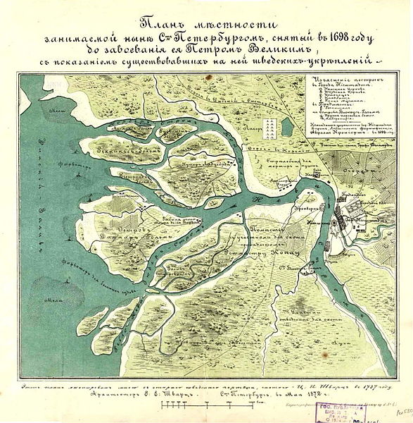
Русский: Карта Санкт-Петербурга. План местности, занимаемой ныне Санкт-Петербургом, снятый в 1698 г.
English: Map of Saint Petersburg (Russia)
Français : Carte de Saint-Pétersbourg.
Español: Mapa de San Petersburgo.
Deutsch: Karte der Sankt Petersburg. |
| Date | |
| Source | http://www.nlr.ru/fonds/maps/spb.htm |
| Author | комендант крепости Ниеншанц, шведский барон Авраам Крониорт |
Licensing[edit]
| Public domainPublic domainfalsefalse |
|
This work is in the public domain in its country of origin and other countries and areas where the copyright term is the author's life plus 100 years or fewer. | |
| This file has been identified as being free of known restrictions under copyright law, including all related and neighboring rights. | |
https://creativecommons.org/publicdomain/mark/1.0/PDMCreative Commons Public Domain Mark 1.0falsefalse
| Annotations InfoField | This image is annotated: View the annotations at Commons |
Ниеншанц,Festung Nyenschanz
File history
Click on a date/time to view the file as it appeared at that time.
| Date/Time | Thumbnail | Dimensions | User | Comment | |
|---|---|---|---|---|---|
| current | 09:05, 19 September 2010 |  | 1,566 × 1,600 (1.13 MB) | Pavlov (talk | contribs) | large version from Russian National Library |
| 11:36, 10 June 2010 |  | 393 × 400 (49 KB) | Peterburg23 (talk | contribs) | == Summary == {{Information |Description= {{Ru|Карта Санкт-Петербурга. План местности, занимаемой ныне Санкт-Петербургом, снятый в 1698 г. }} {{En |
You cannot overwrite this file.
File usage on Commons
There are no pages that use this file.
File usage on other wikis
The following other wikis use this file:
- Usage on ba.wikipedia.org
- Usage on da.wikipedia.org
- Usage on de.wikipedia.org
- Usage on es.wikipedia.org
- Usage on et.wikipedia.org
- Usage on fr.wikipedia.org
- Usage on he.wikipedia.org
- Usage on hy.wikipedia.org
- Usage on lv.wikipedia.org
- Usage on no.wikipedia.org
- Usage on ru.wikipedia.org
- Usage on sl.wikipedia.org
- Usage on sv.wikipedia.org
Metadata
This file contains additional information such as Exif metadata which may have been added by the digital camera, scanner, or software program used to create or digitize it. If the file has been modified from its original state, some details such as the timestamp may not fully reflect those of the original file. The timestamp is only as accurate as the clock in the camera, and it may be completely wrong.
| Orientation | Normal |
|---|---|
| Horizontal resolution | 96 dpi |
| Vertical resolution | 96 dpi |
| Software used | ACD Systems Digital Imaging |
| File change date and time | 12:56, 19 September 2010 |
| Y and C positioning | Centered |
| Exif version | 2.2 |
| DateTime subseconds | 296 |