File:Plan de la cathedrale Angers 1892 Archives nationales France 2.jpg
Jump to navigation
Jump to search

Size of this preview: 445 × 599 pixels. Other resolutions: 178 × 240 pixels | 357 × 480 pixels | 571 × 768 pixels | 761 × 1,024 pixels | 1,522 × 2,048 pixels | 3,076 × 4,139 pixels.
Original file (3,076 × 4,139 pixels, file size: 3.25 MB, MIME type: image/jpeg)
Captions
Captions
Add a one-line explanation of what this file represents
Summary[edit]
| Gustave Raulin: Q65008356
|
|||||||||||||||||||||
|---|---|---|---|---|---|---|---|---|---|---|---|---|---|---|---|---|---|---|---|---|---|
| Artist |
|
 | |||||||||||||||||||
| Title |
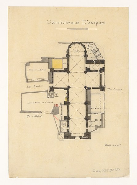
French: Cathédrale d'Angers |
||||||||||||||||||||
| Part of |
Sub-series F/19 of the Archives nationales |
||||||||||||||||||||
| Object type |
architectural drawing / drawing |
||||||||||||||||||||
| Description |
Cathédrale d'Angers. Plan issu des dossiers de travaux de restauration des cathédrales (1802-1912), conservés aux Archives nationales (inventaire et autres documents numérisés consultables en ligne). |
||||||||||||||||||||
| Date |
February 1892 |
||||||||||||||||||||
| Medium |
tracing paper and ink |
||||||||||||||||||||
| Dimensions |
height: 32 cm (12.5 in) |
||||||||||||||||||||
| Collection |
|
||||||||||||||||||||
| Accession number |
CP/F/19/7607, Plan 3 (Archives nationales) |
||||||||||||||||||||
| Object location |
|
||||||||||||||||||||
| Place of creation | Angers | ||||||||||||||||||||
| References |
http://www.siv.archives-nationales.culture.gouv.fr/siv/UD/FRAN_IR_054873/c-61hrmxv07-q9uxyot12qov |
||||||||||||||||||||
| Source/Photographer |
|
||||||||||||||||||||
| Permission (Reusing this file) |
|
||||||||||||||||||||


| Object location | | View this and other nearby images on: OpenStreetMap |
|---|
File history
Click on a date/time to view the file as it appeared at that time.
| Date/Time | Thumbnail | Dimensions | User | Comment | |
|---|---|---|---|---|---|
| current | 14:37, 26 June 2018 | | 3,076 × 4,139 (3.25 MB) | Archives nationales DJI (talk | contribs) | Téléversé avec ComeOn! 3.5.1 |
You cannot overwrite this file.
File usage on Commons
The following 2 pages use this file:
File usage on other wikis
The following other wikis use this file:
- Usage on www.wikidata.org