File:Plan de la cité fortifiée de Vouvant.png
Jump to navigation
Jump to search
Size of this preview: 800 × 596 pixels. Other resolutions: 320 × 238 pixels | 640 × 477 pixels | 1,024 × 763 pixels | 1,280 × 954 pixels | 2,560 × 1,908 pixels | 3,508 × 2,614 pixels.
Original file (3,508 × 2,614 pixels, file size: 825 KB, MIME type: image/png)
Captions
Captions
Add a one-line explanation of what this file represents
Summary[edit]
| Description |
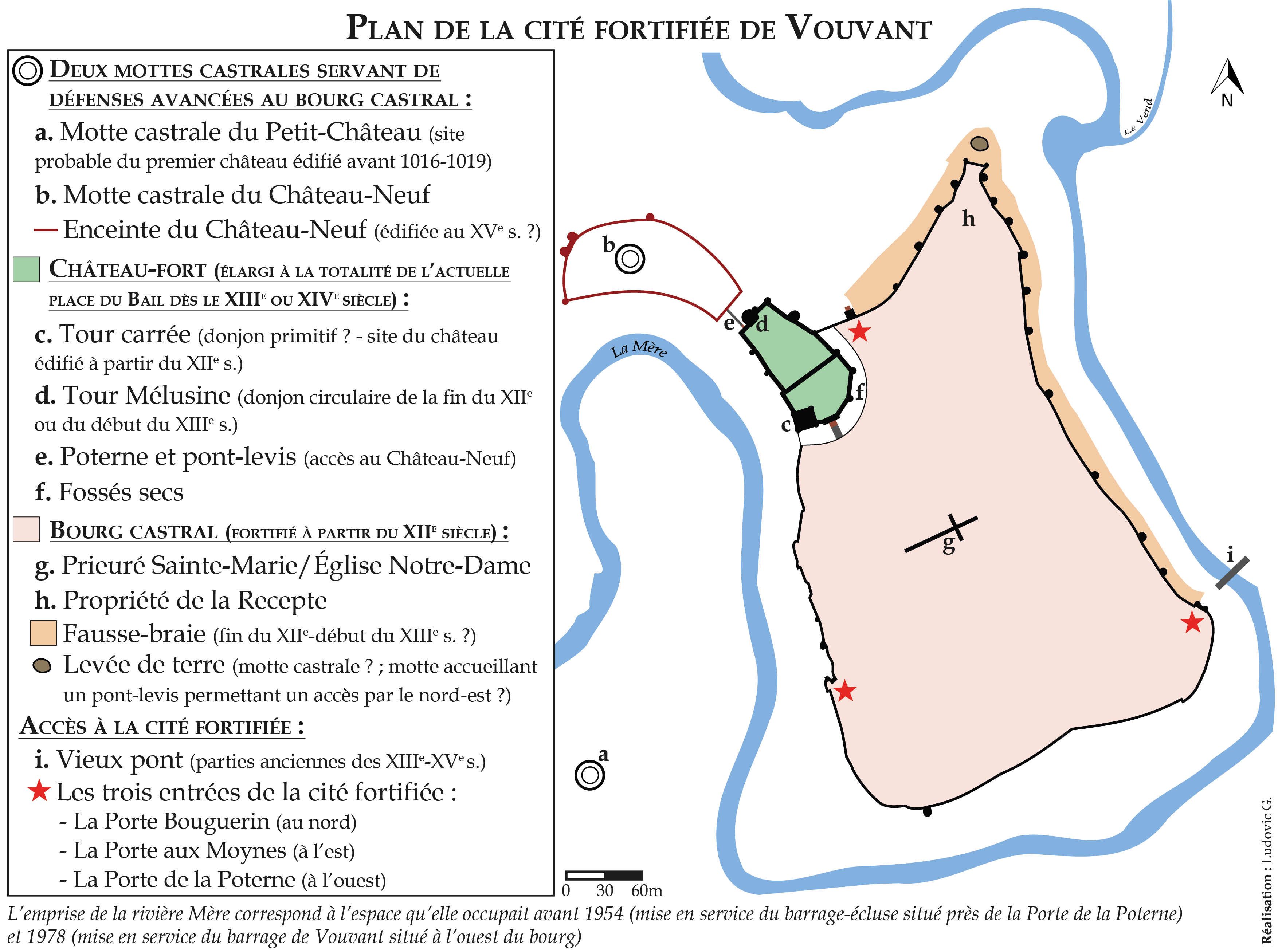
Français : Plan probable de la cité fortifiée de Vouvant, réalisé avec l'appui de recherches historiques. |
| Date | |
| Source | Own work |
| Author | Ludovic G. |
Licensing[edit]
I, the copyright holder of this work, hereby publish it under the following license:
This file is licensed under the Creative Commons Attribution-Share Alike 4.0 International license.
- You are free:
- to share – to copy, distribute and transmit the work
- to remix – to adapt the work
- Under the following conditions:
- attribution – You must give appropriate credit, provide a link to the license, and indicate if changes were made. You may do so in any reasonable manner, but not in any way that suggests the licensor endorses you or your use.
- share alike – If you remix, transform, or build upon the material, you must distribute your contributions under the same or compatible license as the original.
File history
Click on a date/time to view the file as it appeared at that time.
| Date/Time | Thumbnail | Dimensions | User | Comment | |
|---|---|---|---|---|---|
| current | 17:13, 23 February 2020 | | 3,508 × 2,614 (825 KB) | Ludovic G. (talk | contribs) | Rectifications mineures. |
| 20:10, 16 April 2019 |  | 3,508 × 2,614 (820 KB) | Ludovic G. (talk | contribs) | Quelques rectifications : tracé de la fausse-braie et ajout d'informations concernant le tracé de la rivière Mère. | |
| 17:10, 4 January 2019 |  | 3,508 × 2,480 (772 KB) | Ludovic G. (talk | contribs) | Ajout d'informations (fausse-braie, levée de terre au nord-est) et légères rectifications. | |
| 11:39, 6 July 2018 |  | 3,508 × 2,480 (734 KB) | Ludovic G. (talk | contribs) | Rectifications diverses. | |
| 15:43, 24 April 2018 |  | 3,507 × 2,481 (731 KB) | Ludovic G. (talk | contribs) | Meilleure compréhension du plan, améliorations diverses. | |
| 14:43, 22 April 2018 |  | 3,508 × 2,480 (675 KB) | Ludovic G. (talk | contribs) | Format paysage : lecture facilitée. Ajout de quelques précisions. | |
| 13:12, 13 September 2017 |  | 2,444 × 3,058 (530 KB) | Ludovic G. (talk | contribs) | Légères améliorations graphiques. | |
| 20:20, 12 September 2017 |  | 2,444 × 3,058 (530 KB) | Ludovic G. (talk | contribs) | Rectifications graphiques. | |
| 15:14, 12 September 2017 |  | 2,851 × 3,568 (494 KB) | Ludovic G. (talk | contribs) | Rectifications et amélioration de la précision du plan. | |
| 19:50, 18 August 2017 |  | 2,409 × 3,079 (388 KB) | Lomita (talk | contribs) | Suppression tag |
You cannot overwrite this file.
File usage on Commons
There are no pages that use this file.
File usage on other wikis
The following other wikis use this file:
- Usage on fr.wikipedia.org