File:PlanoMontevideo Los62Barrios INE.png
Jump to navigation
Jump to search

Size of this preview: 800 × 580 pixels. Other resolutions: 320 × 232 pixels | 640 × 464 pixels | 1,024 × 742 pixels | 1,153 × 836 pixels.
Original file (1,153 × 836 pixels, file size: 353 KB, MIME type: image/png)
Captions
Captions
Add a one-line explanation of what this file represents
Summary[edit]
| Description |
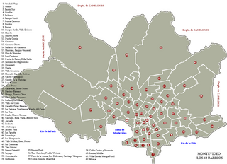
Español: Plano del Departamento de Montevideo. Numeración y Nombre de los Barrios según Cartografía Instituto Nacional Estadísticas. Este mapa tiene errores garrafales tremendos. Urgente los editores y revisores de wikipedia retirarlo. Personalmente estuve hablando con la directora de Cartografía del Instituto Nacional de Estadística del Uruguay, y pude corroborar personalmente que es absolutamente errado. |
| Date | |
| Source | Own work |
| Author | Héctor Tierno |
Licensing[edit]
I, the copyright holder of this work, hereby publish it under the following license:
This file is licensed under the Creative Commons Attribution-Share Alike 3.0 Unported license.
- You are free:
- to share – to copy, distribute and transmit the work
- to remix – to adapt the work
- Under the following conditions:
- attribution – You must give appropriate credit, provide a link to the license, and indicate if changes were made. You may do so in any reasonable manner, but not in any way that suggests the licensor endorses you or your use.
- share alike – If you remix, transform, or build upon the material, you must distribute your contributions under the same or compatible license as the original.
File history
Click on a date/time to view the file as it appeared at that time.
| Date/Time | Thumbnail | Dimensions | User | Comment | |
|---|---|---|---|---|---|
| current | 09:58, 5 November 2011 | | 1,153 × 836 (353 KB) | Héctor Tierno (talk | contribs) |
You cannot overwrite this file.
File usage on Commons
There are no pages that use this file.
File usage on other wikis
The following other wikis use this file:
- Usage on es.wikipedia.org
- Usage on it.wikipedia.org
- Usage on pt.wikipedia.org