File:Plano de la bahia de Assab (1887).jpg

From Wikimedia Commons, the free media repository
Jump to navigation Jump to search

Original file(3,716 × 4,880 pixels, file size: 11.55 MB, MIME type: image/jpeg)
Captions

Captions

Add a one-line explanation of what this file represents

Summary[edit]

Description
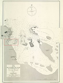
Español: Plano de la bahía de Assab. H. 859 :segun los trabajos italianos é ingleses mas modernos, Escala 1:71.200
English: The Bay of Assab in 1:71,200 scale, based on Italian and English maps
Date
Source Biblioteca Digital Hispánica, Biblioteca Nacional de España, Dirección de Hidrografía (Madrid)
Author E. Fungairiño, A. Pérez e Ibáñez
Other versions
area ceded 1887

Licensing[edit]

Public domain

This work is in the public domain in its country of origin and other countries and areas where the copyright term is the author's life plus 100 years or fewer.


This work is in the public domain in the United States because it was published (or registered with the U.S. Copyright Office) before January 1, 1929.

File history

Click on a date/time to view the file as it appeared at that time.

Date/TimeThumbnailDimensionsUserComment
current12:37, 5 March 2020Thumbnail for version as of 12:37, 5 March 20203,716 × 4,880 (11.55 MB)Roxanna (talk | contribs){{Information |description ={{es|1=Plano de la bahía de Assab. H. 859 :segun los trabajos italianos é ingleses mas modernos, Escala 1:71.200 (El área que Italia prometió ceder a España está marcada en rojo)}} {{en|1=The Bay of Assab in 1:71,200 scale; the area that Italy promised to cede to Spain is marked in red.}} |date =1887 |source =[http://bdh.bne.es/bnesearch/detalle/bdh0000057967 Biblioteca Digital Hispánica], Biblioteca Nacional de España, Dirección de Hidrografía (M...

The following page uses this file: