File:Plesivec 477m Ceske stredohori Vlastislav LT CZ view towards E 172.jpg
From Wikimedia Commons, the free media repository
Jump to navigation
Jump to search

Size of this preview: 800 × 600 pixels. Other resolutions: 320 × 240 pixels | 640 × 480 pixels | 1,024 × 768 pixels | 1,280 × 960 pixels | 1,984 × 1,488 pixels.
Original file (1,984 × 1,488 pixels, file size: 699 KB, MIME type: image/jpeg)
File information
Structured data
Captions
Captions
Add a one-line explanation of what this file represents
| DescriptionPlesivec 477m Ceske stredohori Vlastislav LT CZ view towards E 172.jpg |
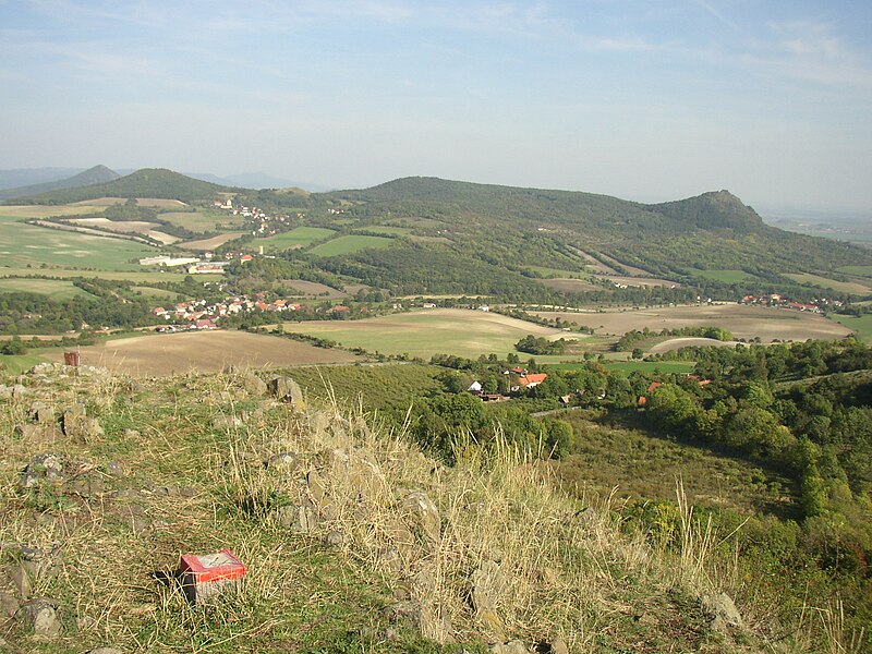
Čeština: Výhled z vrcholu Plešivec (477 m) v Českém středohoří východním směrem. V popředí vpravo osada Chrastná, v údolí potoka Modly vpravo ves Teplá a vlevo obec Vlastislav s patrnou věží hradu a zámkem Skalka. Nad ní dále ve svahu ves Sutom. Vrchy na obzoru: Zccela vlevo v zákrytu Boreč (446 m), před ním Sutomský vrch (505 m), uprostřed výrazná Jezerka (487 m), vpravo Košťál (481 m) se zříceninou hradu Košťálov.
English: View from summit of Plešivec (477 m) in České středohoří Mts. towards east. In the foreground hamlet of Chrastná with wide valley of the Modla stream beyond. In the valley on the left village of Vlastislav with castle tower and chateau visible. On the right side there lies village of Teplá. Hills on the horizon left to right: Boreč (446 m), Sutomský vrch (505 m), at centre Jezerka (487 m) and Košťál (aka Košťálov, 481 m) with another castle ruin. |
| Date | |
| Source | Own work |
| Author | User:Miaow Miaow |
| Permission (Reusing this file) |
PD-self |
| Camera location | 50° 29′ 28″ N, 13° 56′ 19″ E | View this and other nearby images on: OpenStreetMap |
|---|
| Public domainPublic domainfalsefalse |
| I, the copyright holder of this work, release this work into the public domain. This applies worldwide. In some countries this may not be legally possible; if so: I grant anyone the right to use this work for any purpose, without any conditions, unless such conditions are required by law. |
File history
Click on a date/time to view the file as it appeared at that time.
| Date/Time | Thumbnail | Dimensions | User | Comment | |
|---|---|---|---|---|---|
| current | 20:43, 20 February 2012 |  | 1,984 × 1,488 (699 KB) | Miaow Miaow (talk | contribs) | {{Information |Description= {{cs|Výhled z vrcholu Plešivec (477 m) v Českém středohoří východním směrem. V popředí vpravo osada Chrastná, v údolí potoka [[:cs:M |
You cannot overwrite this file.
File usage on Commons
The following 3 pages use this file:
File usage on other wikis
The following other wikis use this file:
- Usage on ceb.wikipedia.org
- Usage on ce.wikipedia.org
- Usage on cs.wikipedia.org
- Usage on es.wikipedia.org
- Usage on eu.wikipedia.org
- Usage on fr.wikipedia.org
- Usage on hu.wikipedia.org
- Usage on lld.wikipedia.org
- Usage on lmo.wikipedia.org
- Usage on pl.wikipedia.org
- Usage on sr.wikipedia.org
- Usage on sv.wikipedia.org
- Usage on tt.wikipedia.org
- Usage on vi.wikipedia.org
- Usage on www.wikidata.org
Metadata
This file contains additional information such as Exif metadata which may have been added by the digital camera, scanner, or software program used to create or digitize it. If the file has been modified from its original state, some details such as the timestamp may not fully reflect those of the original file. The timestamp is only as accurate as the clock in the camera, and it may be completely wrong.
| Image title | OLYMPUS DIGITAL CAMERA |
|---|---|
| Camera manufacturer | OLYMPUS OPTICAL CO.,LTD |
| Camera model | C300Z,D550Z |
| Exposure time | 1/1,000 sec (0.001) |
| F-number | f/2.9 |
| ISO speed rating | 60 |
| Date and time of data generation | 14:27, 4 October 2011 |
| Lens focal length | 6 mm |
| Orientation | Normal |
| Horizontal resolution | 72 dpi |
| Vertical resolution | 72 dpi |
| Software used | v574p-76 |
| File change date and time | 14:27, 4 October 2011 |
| Y and C positioning | Co-sited |
| Exposure Program | Normal program |
| Exif version | 2.1 |
| Date and time of digitizing | 14:27, 4 October 2011 |
| Meaning of each component |
|
| Image compression mode | 1 |
| APEX exposure bias | 0 |
| Maximum land aperture | 3.1 APEX (f/2.93) |
| Metering mode | Pattern |
| Light source | Unknown |
| Flash | Flash did not fire |
| Supported Flashpix version | 1 |
| Color space | sRGB |
| File source | Digital still camera |
| Scene type | A directly photographed image |