File:Podunavlje 1994.png
Jump to navigation
Jump to search

Size of this preview: 411 × 599 pixels. Other resolutions: 164 × 240 pixels | 329 × 480 pixels | 881 × 1,285 pixels.
Original file (881 × 1,285 pixels, file size: 92 KB, MIME type: image/png)
Captions
Captions
Add a one-line explanation of what this file represents
Summary[edit]
| Description |
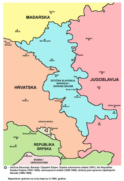
English: Map of the Eastern Slavonia, Baranja and Western Syrmia - Croatian language version. |
| Source | Own work |
| Author | PANONIAN |
Licensing[edit]
I, the copyright holder of this work, hereby publish it under the following license:
| This file is made available under the Creative Commons CC0 1.0 Universal Public Domain Dedication. | |
| The person who associated a work with this deed has dedicated the work to the public domain by waiving all of their rights to the work worldwide under copyright law, including all related and neighboring rights, to the extent allowed by law. You can copy, modify, distribute and perform the work, even for commercial purposes, all without asking permission.
|
References[edit]
- Sve srpske mape - od šestog veka do Pariza, Specijalno izdanje BLICA, Decembar 1995
- Dr Tomislav Bogavac, Nestajanje Srba, Niš, 1994.
- Miodrag Milošević, Geografija za 8. razred osnovne škole, Beograd, 1994.
- Dragan Rodić, Geografija za I ili III razred srednje škole, Beograd, 1995.
- Istorijski atlas, Geokarta, Beograd, 1999.
- Richard Overy, The Times History of the 20th Century, Times Books, London, 2004.
- The Times History of Europe, Times Books, London, 2002.
- Slavko Vejinović, Srbi u dijaspori u prošlosti i sadašnjosti, Novi Sad, 1999.
- Tim Džuda, Srbi - istorija, mit i razaranje Jugoslavije, Beograd, 2003.
- Džon R. Lempi, Jugoslavija kao istorija, Beograd, 2004.
- Nada Miletić Stanić, Pravoslavne crkve u Baranji, Novi Sad, 1999.
- http://web.ku.edu/~eceurope/hist557/lect20_files/yugoslavprovinces.jpg archive copy at the Wayback Machine
- http://terkepek.adatbank.transindex.ro/kepek/netre/292.gif
- http://www.pointernet.pds.hu/touristinfo/croatia/image/g.jpg archive copy at the Wayback Machine
- http://clip2net.com/clip/m6499/1217833413-krajina_army_territorial_division-jpg-34kb.jpg
- http://profile.ak.fbcdn.net/hprofile-ak-snc4/50514_294052851171_2302284_n.jpg archive copy at the Wayback Machine
- http://www.vecernji.hr/slika-500x329/vijesti/otkrivamo-britanci-trazili-da-baranju-dio-istocne-slavonije-predamo-srbiji-slika-85519[dead link]
- http://www.srpskapolitika.com/krajina/mapa211.jpg archive copy at the Wayback Machine
- http://www.srpska-mreza.com/MAPS/Ethnic-groups/map-UN-1994.jpg
- http://www.srpskapolitika.com/krajina/etnicka_karta.jpg archive copy at the Wayback Machine
- http://www.srpskapolitika.com/krajina/mapa311.jpg archive copy at the Wayback Machine
- http://farm1.static.flickr.com/45/110412384_09ffb827cb.jpg
File history
Click on a date/time to view the file as it appeared at that time.
| Date/Time | Thumbnail | Dimensions | User | Comment | |
|---|---|---|---|---|---|
| current | 11:19, 8 June 2012 | | 881 × 1,285 (92 KB) | PANONIAN (talk | contribs) | {{Information |Description ={{en|1=Map of the Eastern Slavonia, Baranja and Western Syrmia - Croatian language version.}} |Source ={{own}} |Author =PANONIAN |Date = |Permission = |other_versions = }} |
You cannot overwrite this file.
File usage on Commons
There are no pages that use this file.
File usage on other wikis
The following other wikis use this file:
- Usage on bs.wikipedia.org
- Usage on sh.wikipedia.org