File:Powiat łódzki wschodni location map.png

Original file (1,304 × 1,304 pixels, file size: 432 KB, MIME type: image/png)
Captions
Captions
Summary[edit]
| Description |
English: Location map |
| Date | |
| Source | Own work |
| Author | Smat |
| Description |
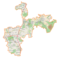
Polski: Mapa powiatu łódzkiego wschodniego, Polska
English: Map of powiat łódzki wschodni, Poland |
|||||||||
| Date | ||||||||||
| Source | You may find a page on the OpenStreetMap wiki page for powiat łódzki wschodni | |||||||||
| Creator |
OpenStreetMap contributors OpenStreetMap contributors |
|||||||||
| Permission (Reusing this file) |
OpenStreetMap data is available under the Open Database License (details). Map tiles are licensed under the Creative Commons Attribution-ShareAlike 2.0 license (CC-BY-SA 2.0).
This file is licensed under the Creative Commons Attribution-Share Alike 2.0 Generic license.
|
|||||||||
| Geotemporal data | ||||||||||
| Bounding box |
|
|||||||||
| Georeferencing | If inappropriate please set warp_status = skip to hide. | |||||||||
Licensing[edit]
| This work contains information from OpenStreetMap, which is made available under the Open Database License (ODbL).
The ODbL does not require any particular license for maps produced from ODbL data. Prior to 1 August 2020, map tiles produced by the OpenStreetMap Foundation were licensed under the CC-BY-SA-2.0 license. Maps produced by other people may be subject to other licences. |
File history
Click on a date/time to view the file as it appeared at that time.
| Date/Time | Thumbnail | Dimensions | User | Comment | |
|---|---|---|---|---|---|
| current | 16:09, 7 November 2017 | | 1,304 × 1,304 (432 KB) | Smat (talk | contribs) | User created page with UploadWizard |
You cannot overwrite this file.
File usage on Commons
There are no pages that use this file.
File usage on other wikis
The following other wikis use this file:
- Usage on eo.wikipedia.org
- Usage on pl.wikipedia.org
- Andrespol
- Rzgów
- Tuszyn
- Wodzinek
- Kurowice (województwo łódzkie)
- Gałkówek
- Bedoń Przykościelny
- Bedoń-Wieś
- Bądzyń
- Będzelin
- Boginia
- Borchówka
- Bronisin Dworski
- Byszewy
- Czyżeminek
- Gałków Duży
- Gałkówek-Parcela
- Gałków Mały
- Giemzów
- Gospodarz (województwo łódzkie)
- Huta Wiskicka
- Jutroszew
- Kraszew (powiat łódzki wschodni)
- Kruszów
- Kurowice Kościelne
- Kalino
- Kalinko
- Leśne Odpadki
- Modlica (województwo łódzkie)
- Nowe Skoszewy
- Nowy Bedoń
- Nowy Redzeń
- Moskwa (województwo łódzkie)
- Pałczew
- Plichtów
- Przanowice
- Przypusta
- Rydzynki
- Różyca (wieś)
- Regny (wieś w województwie łódzkim)
- Prawda (województwo łódzkie)
- Szczukwin
- Stary Redzeń
- Stara Gadka
- Stare Skoszewy
- Starowa Góra
- Tuszynek Majoracki
- Wardzyn
- Wiączyń Dolny
View more global usage of this file.