File:Powiat lubelski location map.png

Original file (1,171 × 1,464 pixels, file size: 529 KB, MIME type: image/png)
Captions
Captions
Summary[edit]
| Description |
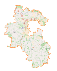
English: Location map |
| Date | |
| Source | Own work |
| Author | Smat |
| Description |
Polski: Mapa powiatu lubelskiego, Polska
English: Map of powiat lubelski, Poland |
|||||||||
| Date | ||||||||||
| Source | You may find a page on the OpenStreetMap wiki page for powiat lubelski | |||||||||
| Creator |
OpenStreetMap contributors OpenStreetMap contributors |
|||||||||
| Permission (Reusing this file) |
OpenStreetMap data is available under the Open Database License (details). Map tiles are licensed under the Creative Commons Attribution-ShareAlike 2.0 license (CC-BY-SA 2.0).
This file is licensed under the Creative Commons Attribution-Share Alike 2.0 Generic license.
|
|||||||||
| Geotemporal data | ||||||||||
| Bounding box |
|
|||||||||
| Georeferencing | If inappropriate please set warp_status = skip to hide. | |||||||||
Licensing[edit]
| This work contains information from OpenStreetMap, which is made available under the Open Database License (ODbL).
The ODbL does not require any particular license for maps produced from ODbL data. Prior to 1 August 2020, map tiles produced by the OpenStreetMap Foundation were licensed under the CC-BY-SA-2.0 license. Maps produced by other people may be subject to other licences. |
File history
Click on a date/time to view the file as it appeared at that time.
| Date/Time | Thumbnail | Dimensions | User | Comment | |
|---|---|---|---|---|---|
| current | 14:23, 17 September 2017 | | 1,171 × 1,464 (529 KB) | Smat (talk | contribs) | User created page with UploadWizard |
You cannot overwrite this file.
File usage on Commons
There are no pages that use this file.
File usage on other wikis
The following other wikis use this file:
- Usage on eo.wikipedia.org
- Usage on pl.wikipedia.org
- Pawłów (powiat lubelski)
- Strzyżewice (województwo lubelskie)
- Bychawa
- Niemce
- Bełżyce
- Powiat lubelski
- Rezerwat przyrody Chmiel
- Rezerwat przyrody Las Królewski
- Rezerwat przyrody Podzamcze
- Kozłowiecki Park Krajobrazowy
- Garbów (powiat lubelski)
- Rezerwat przyrody Olszanka (woj. lubelskie)
- Czerniejówka
- Wojciechów (powiat lubelski)
- Zamek w Bełżycach
- Abramowice Prywatne
- Baszki (województwo lubelskie)
- Boduszyn
- Borzechów
- Borzechów-Kolonia
- Bychawka Druga
- Bychawka Druga-Kolonia
- Bychawka Pierwsza
- Bychawka Trzecia
- Bychawka Trzecia-Kolonia
- Bystrzyca Nowa
- Bystrzyca Stara
- Chmielnik-Kolonia
- Chmiel Pierwszy
- Cuple
- Czerniejów-Kolonia
- Czółna (województwo lubelskie)
- Ćmiłów
- Dobrowola (województwo lubelskie)
- Dragany
- Dys
- Dębszczyzna
- Głuszczyzna
- Gałęzów-Kolonia Druga
- Gałęzów-Kolonia Pierwsza
- Gierniak
- Giełczew-Doły
- Gutanów
- Halinówka
- Iżyce
- Jabłonna Pierwsza
- Jakubowice Konińskie
- Jakubowice Konińskie-Kolonia
- Jakubowice Murowane
View more global usage of this file.