File:Powiat lubiński location map.png

Original file (1,136 × 1,298 pixels, file size: 485 KB, MIME type: image/png)
Captions
Captions
Summary[edit]
| Description |
English: Location map |
| Date | |
| Source | Own work |
| Author | Smat |
| Description |
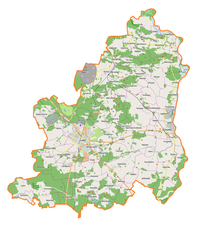
Polski: Mapa powiatu lubińskiego, Polska
English: Map of powiat lubiński, Poland |
|||||||||
| Date | ||||||||||
| Source | You may find a page on the OpenStreetMap wiki page for powiat lubiński | |||||||||
| Creator |
OpenStreetMap contributors OpenStreetMap contributors |
|||||||||
| Permission (Reusing this file) |
OpenStreetMap data is available under the Open Database License (details). Map tiles are licensed under the Creative Commons Attribution-ShareAlike 2.0 license (CC-BY-SA 2.0).
This file is licensed under the Creative Commons Attribution-Share Alike 2.0 Generic license.
|
|||||||||
| Geotemporal data | ||||||||||
| Bounding box |
|
|||||||||
| Georeferencing | If inappropriate please set warp_status = skip to hide. | |||||||||
Licensing[edit]
| This work contains information from OpenStreetMap, which is made available under the Open Database License (ODbL).
The ODbL does not require any particular license for maps produced from ODbL data. Prior to 1 August 2020, map tiles produced by the OpenStreetMap Foundation were licensed under the CC-BY-SA-2.0 license. Maps produced by other people may be subject to other licences. |
File history
Click on a date/time to view the file as it appeared at that time.
| Date/Time | Thumbnail | Dimensions | User | Comment | |
|---|---|---|---|---|---|
| current | 15:58, 17 January 2017 | | 1,136 × 1,298 (485 KB) | Smat (talk | contribs) | User created page with UploadWizard |
You cannot overwrite this file.
File usage on Commons
There are no pages that use this file.
File usage on other wikis
The following other wikis use this file:
- Usage on eo.wikipedia.org
- Usage on pl.wikipedia.org
- Lubin
- KGHM Polska Miedź
- Ścinawa
- Osiek (powiat lubiński)
- Parszowice
- Wądroże
- Brodowice
- Brodów
- Buczynka (województwo dolnośląskie)
- Bukowna
- Chełmek Wołowski
- Chobienia (powiat lubiński)
- Chróstnik
- Ciechłowice
- Dłużyce
- Dziesław (województwo dolnośląskie)
- Gorzelin
- Gwizdanów
- Jurcz
- Juszowice
- Kłopotów (województwo dolnośląskie)
- Krzeczyn Mały
- Krzeczyn Wielki
- Karczowiska
- Lisiec (województwo dolnośląskie)
- Miłoradzice
- Miroszowice
- Mleczno
- Naroczyce
- Nieszczyce
- Orsk (Polska)
- Przychowa
- Radomiłów
- Raszowa Mała
- Raszówka
- Redlice
- Ręszów
- Składowice
- Szklary Górne
- Stara Rudna
- Toszowice
- Buszkowice (województwo dolnośląskie)
- Bytków (województwo dolnośląskie)
- Czerniec (województwo dolnośląskie)
- Dąbrowa Dolna (województwo dolnośląskie)
- Dąbrowa Górna (województwo dolnośląskie)
- Dębiec (województwo dolnośląskie)
- Dziewin (województwo dolnośląskie)
- Gawrony (województwo dolnośląskie)
View more global usage of this file.