File:Pumice (Mt. St. Helens, Washington State, USA) 2.jpg

Original file (2,477 × 1,818 pixels, file size: 2.67 MB, MIME type: image/jpeg)
Captions
Captions
Summary[edit]
_2.jpg&action=edit§ion=1)
| Description |
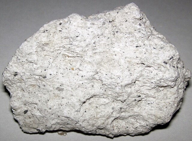
English: Pumice from the Holocene of Washington State, USA. (~6.1 centimeters across at its widest)
The 1980 Mt. St. Helens eruption was the largest in recent American history. The volcano was intermittently active until 1986. Minor activity occurred from 1989 to 1991 and from 2004 to 2006. Mt. St. Helens is the most active volcano in the Cascade Range, a series of subduction zone stratovolcanoes in a ~north-south line from northern California to Oregon to Washington State to southwestern British Columbia. St. Helens is a 40,000 to 50,000 year old, andesitic-dacitic-basaltic volcano that typically has explosive ash eruptions (as do all subduction zone stratovolcanoes). The 1980 eruption was a northward-directed lateral blast that followed an enormous landslide of the northern face of the volcano. The landslide was triggered by a moderate earthquake at 8:32 AM, Sunday, 18 May 1980. Snow and ice on the mountain melted during the eruption, mixed with ash and other debris, and rushed down nearby river valleys as lahars (volcanic mud flows). The ash, lapilli, and pumice erupted from Mt. St. Helens in May 1980 was dacite, an intermediate extrusive igneous rock. Most of the air-fall dacite ash fell in Washington State, Oregon, and Idaho, but a minor amount accumulated as far east as Minnesota and Oklahoma. Light dustings of ash were also observed in Ohio. Seen here is pumice, a felsic to intermediate to alkaline, frothy-textured, extrusive igneous rock. Pumice ranges from white to light gray to light tan in color. It is lightweight and often floats in water. Location of volcano: Mt. St. Helens, northwestern Skamania County, Cascade Range, southwestern Washington State, USA (46˚ 12’ 04” North, 122˚ 11” 18” West) Sample collection site: unknown/unrecorded |
| Date | |
| Source | https://www.flickr.com/photos/47445767@N05/40278694953/ |
| Author | James St. John |
Licensing[edit]
_2.jpg&action=edit§ion=2)
- You are free:
- to share – to copy, distribute and transmit the work
- to remix – to adapt the work
- Under the following conditions:
- attribution – You must give appropriate credit, provide a link to the license, and indicate if changes were made. You may do so in any reasonable manner, but not in any way that suggests the licensor endorses you or your use.
| This image was originally posted to Flickr by James St. John at https://flickr.com/photos/47445767@N05/40278694953. It was reviewed on 22 October 2020 by FlickreviewR 2 and was confirmed to be licensed under the terms of the cc-by-2.0. |
File history
Click on a date/time to view the file as it appeared at that time.
| Date/Time | Thumbnail | Dimensions | User | Comment | |
|---|---|---|---|---|---|
| current | 19:04, 22 October 2020 | | 2,477 × 1,818 (2.67 MB) | Ser Amantio di Nicolao (talk | contribs) | Uploaded a work by James St. John from https://www.flickr.com/photos/47445767@N05/40278694953/ with UploadWizard |
You cannot overwrite this file.
File usage on Commons
There are no pages that use this file.
_2.jpg&oldid=619811805)