File:QuangNamThoiLe.png
Jump to navigation
Jump to search
No higher resolution available.
QuangNamThoiLe.png (347 × 550 pixels, file size: 113 KB, MIME type: image/png)
Captions
Captions
Add a one-line explanation of what this file represents
Summary[edit]
| Description |
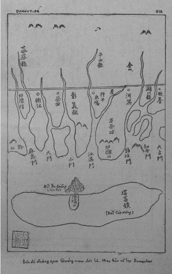
Tiếng Việt: Bản đồ đường qua xứ Quảng Nam đời Lê, theo Thiên Nam lộ đồ vẽ lại năm 1741(bản sao chép của Dumoutier). Bãi cát vàng trên bản đồ tức là Hoàng Sa. |
||||
| Date | |||||
| Source | http://dantri.com.vn/su-kien/co-so-phap-ly-khang-dinh-chu-quyen-doi-voi-quan-dao-hoang-sa-va-truong-sa-cua-viet-nam-489216.htm | ||||
| Author | Dumoutier | ||||
| Permission (Reusing this file) |
|
||||
Licensing[edit]
|
This work is in the public domain in its country of origin and other countries and areas where the copyright term is the author's life plus 100 years or fewer. | |
| This file has been identified as being free of known restrictions under copyright law, including all related and neighboring rights. | |
File history
Click on a date/time to view the file as it appeared at that time.
| Date/Time | Thumbnail | Dimensions | User | Comment | |
|---|---|---|---|---|---|
| current | 22:58, 29 July 2015 | | 347 × 550 (113 KB) | Cmdrjameson (talk | contribs) | Compressed with pngout. Reduced by 62kB (35% decrease). |
| 15:23, 19 January 2014 |  | 347 × 550 (175 KB) | Doãn Hiệu (talk | contribs) | {{Information |Description ={{vi|1=Bản đồ đường qua xứ Quảng Nam đời Lê, theo Thiên Nam lộ đồ vẽ lại năm 1741(bản sao chép của Dumoutier). Bãi cát vàng trên bản đồ tức là Hoàng Sa.}} |Source =htt... |
You cannot overwrite this file.
File usage on Commons
There are no pages that use this file.
File usage on other wikis
The following other wikis use this file:
- Usage on vi.wikipedia.org
- Usage on zh.wikipedia.org