File:Quehanna Wild Area base map.png
Jump to navigation
Jump to search
Size of this preview: 726 × 599 pixels. Other resolutions: 291 × 240 pixels | 582 × 480 pixels | 931 × 768 pixels | 1,065 × 879 pixels.
Original file (1,065 × 879 pixels, file size: 73 KB, MIME type: image/png)
Captions
Captions
Add a one-line explanation of what this file represents
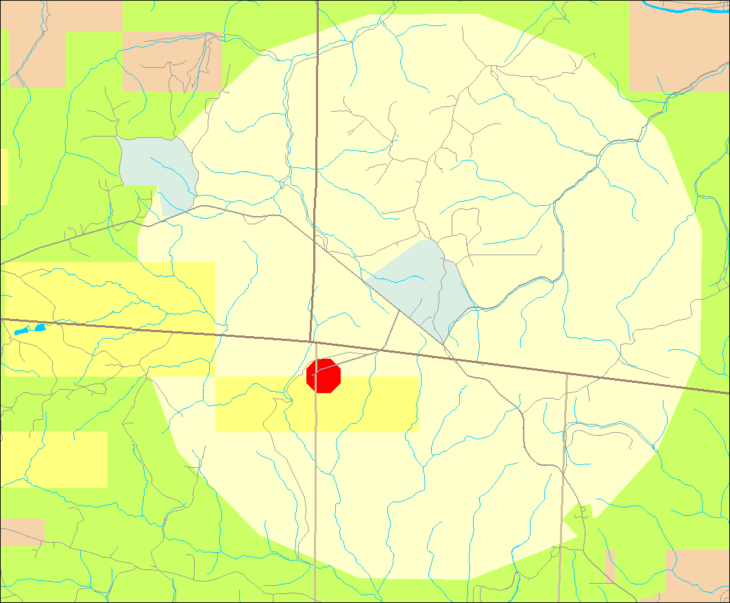
| Description | Map of Quehanna Wild Area in Cameron, Clearfield, and Elk Counties, Pennsylvania, USA |
| Date | |
| Source | water and roads taken from US Census website [1] and modified by User:Ruhrfisch, property boundaries based on these PA DCNR maps of Elk and Moshannon State Forests |
| Author | US Census, Ruhrfisch |
| Permission (Reusing this file) |
US Census / US Government work is public domain, my modifications licensed under the GNU Free Documentation License |
| Other versions |
 |
Note: Color scheme - ivory is Quehanna Wild Area, green is Moshannon State Forest and Elk State Forest, yellow is Pennsylvania State Game Land, light green is State Forest Natural Areas, red is the restricted zone around the former nuclear reactor, and brown is private land.
Licensing[edit]
I, Ruhrfisch, the copyright holder of this work, hereby publishes it under the following licenses:

|
Permission is granted to copy, distribute and/or modify this document under the terms of the GNU Free Documentation License, Version 1.2 or any later version published by the Free Software Foundation; with no Invariant Sections, no Front-Cover Texts, and no Back-Cover Texts. A copy of the license is included in the section entitled GNU Free Documentation License. |
| This file is licensed under the Creative Commons Attribution-Share Alike 3.0 Unported license. | ||
| Attribution: I, Ruhrfisch | ||
| ||
| This licensing tag was added to this file as part of the GFDL licensing update. |
You may select the license of your choice.
and
This image or file is a work of a United States Census Bureau employee, taken or made as part of that person's official duties. As a work of the U.S. federal government, the image is in the public domain.
|
 |
File history
Click on a date/time to view the file as it appeared at that time.
| Date/Time | Thumbnail | Dimensions | User | Comment | |
|---|---|---|---|---|---|
| current | 16:53, 3 March 2010 | | 1,065 × 879 (73 KB) | Ruhrfisch (talk | contribs) | {{Information| |Description= Map of Quehanna Wild Area in Cameron, Clearfield, and Elk Counties, Pennsylvania, USA |Source= water and roads taken from US Census website [http://factfinder.census.gov/] and modified by User:Ruhrfisch, property boundari |
You cannot overwrite this file.
File usage on Commons
The following page uses this file: