File:Racija1942 02.png
Jump to navigation
Jump to search

Size of this preview: 447 × 599 pixels. Other resolutions: 179 × 240 pixels | 358 × 480 pixels | 942 × 1,263 pixels.
Original file (942 × 1,263 pixels, file size: 84 KB, MIME type: image/png)
Captions
Captions
Add a one-line explanation of what this file represents
Summary[edit]
| Description |
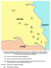
English: Map of places affected by the raid in January 1942 in southern Bačka, in which Hungarian occupational forces killed 3,809 civilians mostly of Serb, Jewish and Roma ethnicity (according to historian Zvonimir Golubović) - Serbian language version
Српски / srpski: Мапа места захваћених рацијом у јануару 1942. године у јужној Бачкој, у којој су мађарске окупационе снаге убиле 3.809 цивила углавном српске, јеврејске и ромске народности (према историчару Звонимиру Голубовићу) - верзија на српском језику |
| Date | 30 June 2009 (original upload date) |
| Source | No machine-readable source provided. Own work assumed (based on copyright claims). |
| Author | No machine-readable author provided. PANONIAN assumed (based on copyright claims). |
References[edit]
Reference for this map is following book:
- Zvonimir Golubović, Racija u Južnoj Bačkoj 1942. godine, Novi Sad, 1992.
Референца за ову мапу је следећа књига:
- Звонимир Голубовић, Рација у Јужној Бачкој 1942. године, Нови Сад, 1992.
Other references:
- Aleksandar Veljić, Racija - zaboravljen genocid, Beograd, 2007.
- Jovan Pejin, Velikomađarski kapric, Zrenjanin, 2007.
- Dimitrije Boarov, Politička istorija Vojvodine, Novi Sad, 2001.
- Peter Rokai - Zoltan Đere - Tibor Pal - Aleksandar Kasaš, Istorija Mađara, Beograd, 2002.
- Laza Čurčić, Sećanje na titelske mučenike o Božiću 1942, Titelski letopis, Titel, 2001.
Licensing[edit]
self made map by user:PANONIAN
| I, the copyright holder of this work, release this work into the public domain. This applies worldwide. In some countries this may not be legally possible; if so: I grant anyone the right to use this work for any purpose, without any conditions, unless such conditions are required by law. |
File history
Click on a date/time to view the file as it appeared at that time.
| Date/Time | Thumbnail | Dimensions | User | Comment | |
|---|---|---|---|---|---|
| current | 18:57, 9 October 2013 | | 942 × 1,263 (84 KB) | PANONIAN (talk | contribs) | aesthetics |
| 20:49, 8 December 2010 |  | 945 × 1,266 (85 KB) | PANONIAN (talk | contribs) | aesthetics | |
| 13:43, 30 June 2009 |  | 945 × 1,266 (85 KB) | PANONIAN (talk | contribs) | ==Description== * '''English''': Map of places affected by the raid in January 1942 in southern Bačka, in which Hungarian occupational forces killed 3,809 civilians mostly of Serb, Jewish and Roma ethnicity (according to historian Zvonimir Golubović) - |
You cannot overwrite this file.
File usage on Commons
There are no pages that use this file.
File usage on other wikis
The following other wikis use this file:
- Usage on sh.wikipedia.org
- Usage on sr.wikipedia.org