File:Radarreflektor (25112395332).jpeg
Jump to navigation
Jump to search

Size of this preview: 800 × 534 pixels. Other resolutions: 320 × 214 pixels | 640 × 427 pixels | 1,024 × 683 pixels | 1,280 × 854 pixels | 2,560 × 1,708 pixels | 3,776 × 2,520 pixels.
Original file (3,776 × 2,520 pixels, file size: 4.24 MB, MIME type: image/jpeg)
Captions
Captions
Add a one-line explanation of what this file represents
Summary[edit]
.jpeg&action=edit§ion=1)
| Description |
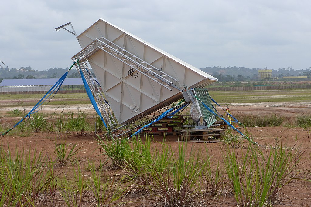
Deutsch: Der Reflektor mit seinen drei senkrecht aufeinander stehenden Flächen sammelt die gesamte einfallende Energie und sendet sie wieder direkt in die Richtung zurück aus der sie kam - analog zu einem Katzenauge im sichtbaren Bereich. Die gesamte Energie scheint dabei direkt aus der inneren Ecke des Reflektors zu kommen. Diese hintere Ecke wurde sehr genau mit GPS vermessen. So wurde auf wenige Zentimeter genau bestimmt, ob die Radardaten geometrisch exakt sind. Eventuelle Probleme in der Hardware können sich beispielsweise in einer scheinbaren Positionsänderung widerspiegeln. Zum anderen wird die Stärke und die Phasenbeziehungen der einfallenden horizontal bzw. vertikal polarisierten Wellen ausgewertet, auch hier wieder mit dem Ziel sicherzustellen, dass die F-SAR Hardware im Flugzeug korrekt funktioniert.
Wissenschaftler des Deutschen Zentrums für Luft- und Raumfahrt (DLR) fliegen vom 01. bis zum 29. Februar im zentralafrikanischen Gabun zahlreiche Messflüge, um den Zustand des Regenwaldes zu bestimmen. Dabei setzen sie hochmoderne Radartechnologie ein. Die gewonnenen Daten helfen dabei, Klimamodelle zu verbessern und die Erderwärmung besser zu verstehen. Die Kampagne wird in Kooperation mit der europäischen (ESA), der französischen (ONERA), der gabunischen (AGEOS) und dem amerikanischen Raumfahrtzentrum (NASA) durchgeführt. |
| Date | Taken on 12 February 2016, 12:44:44 |
| Source | Radarreflektor |
| Author | DLR_de |
| Flickr set | Regenwald unterm Radar |
| Flickr tags | radartechnik; ageos; zentralafrika; libreville; klima; afrisar; dlr; climate; regenwald; turboprob; fsar; hochfrequenz; outdoor; biomasse; nasa; esa; gabun; luftfahrt; do228; rainforest; klimaforschung; onera; aerospace; deutscheszentrumfürluftundraumfahrt |
Licensing[edit]
.jpeg&action=edit§ion=2)
This file is licensed under the Creative Commons Attribution 2.0 Generic license.
- You are free:
- to share – to copy, distribute and transmit the work
- to remix – to adapt the work
- Under the following conditions:
- attribution – You must give appropriate credit, provide a link to the license, and indicate if changes were made. You may do so in any reasonable manner, but not in any way that suggests the licensor endorses you or your use.
| This image was originally posted to Flickr by DLR_de at https://flickr.com/photos/48213136@N06/25112395332. It was reviewed on 29 November 2022 by FlickreviewR 2 and was confirmed to be licensed under the terms of the cc-by-2.0. |
| This media has been released under a free license by the Deutsches Zentrum für Luft- und Raumfahrt (DLR). Their website states: "Where expressly stated, DLR images and videos are covered by a Creative Commons Attribution 3.0 Germany (CC BY 3.0) licence. This licence grants permission to reproduce or distribute the work, to make the work and/or its contents publically available, to alter or edit the work and/or its contents and to make commercial use of the work, provided that you explicitly mention DLR as its source in a clearly legible format. Examples: 'Photo: DLR, CC-BY 3.0', 'Images: DLR, CC-BY 3.0', 'Video: DLR, CC-BY 3.0'." To the uploader: You must provide a link (URL) to the original file and the authorship information if available. |
This file is licensed under the Creative Commons Attribution 3.0 Germany license.
Attribution: DLR, CC-BY 3.0
- You are free:
- to share – to copy, distribute and transmit the work
- to remix – to adapt the work
- Under the following conditions:
- attribution – You must give appropriate credit, provide a link to the license, and indicate if changes were made. You may do so in any reasonable manner, but not in any way that suggests the licensor endorses you or your use.

File history
Click on a date/time to view the file as it appeared at that time.
| Date/Time | Thumbnail | Dimensions | User | Comment | |
|---|---|---|---|---|---|
| current | 23:38, 29 November 2022 | | 3,776 × 2,520 (4.24 MB) | OptimusPrimeBot (talk | contribs) | #Spacemedia - Upload of https://live.staticflickr.com/1617/25112395332_19992ddd97_o.jpg via Commons:Spacemedia |
You cannot overwrite this file.
File usage on Commons
The following page uses this file:
.jpeg&oldid=807973518)